Saharan Air Layer dust reaches the Lesser Antilles, Puerto Rico and the Gulf of Mexico
![GOES-16 Split Window Difference (10.3 µm – 12.3 µm) and Dust RGB images, with surface reports plotted in white [click to play animation | MP4]](https://cimss.ssec.wisc.edu/satellite-blog/images/2020/06/200621_goes16_splitWindowDifference_dustRGB_Saharan_Air_Layer_dust_anim.gif)
GOES-16 Split Window Difference (10.3 µm – 12.3 µm) and Dust RGB images, with surface reports plotted in white [click to play animation | MP4]
GOES-16 True Color RGB images created using Geo2Grid (below) showed the characteristic tan hues of the dust plume during daylight hours (1000-2200 UTC).
![GOES-16 True Color RGB images [click to play animation | MP4]](https://cimss.ssec.wisc.edu/satellite-blog/images/2020/06/200621_goes16_trueColorRGB_Saharan_Air_Layer_dust_anim.gif)
GOES-16 True Color RGB images [click to play animation | MP4]
===== 22 June Update =====
![GOES-16 Split Window Difference (10.3 µm – 12.3 µm) and Aerosol Optical Depth images, with surface reports plotted in white [click to play animation | MP4]](https://cimss.ssec.wisc.edu/satellite-blog/images/2020/06/200622_goes16_splitWindowDifference_aerosolOpticalDepth_Saharan_Air_Layer_dust_anim.gif)
GOES-16 Split Window Difference (10.3 µm – 12.3 µm) and Aerosol Optical Depth images, with surface reports plotted in white [click to play animation | MP4]
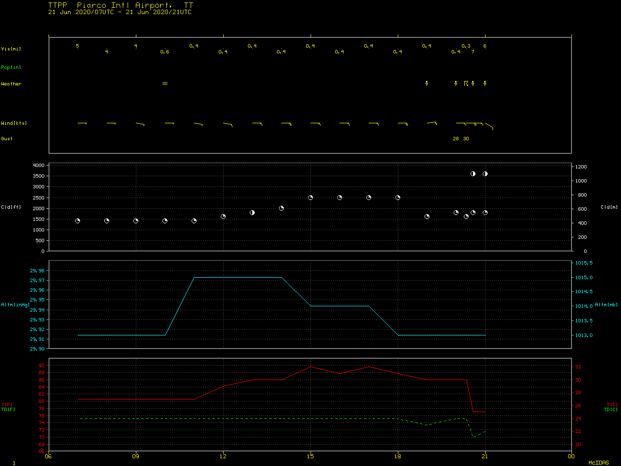
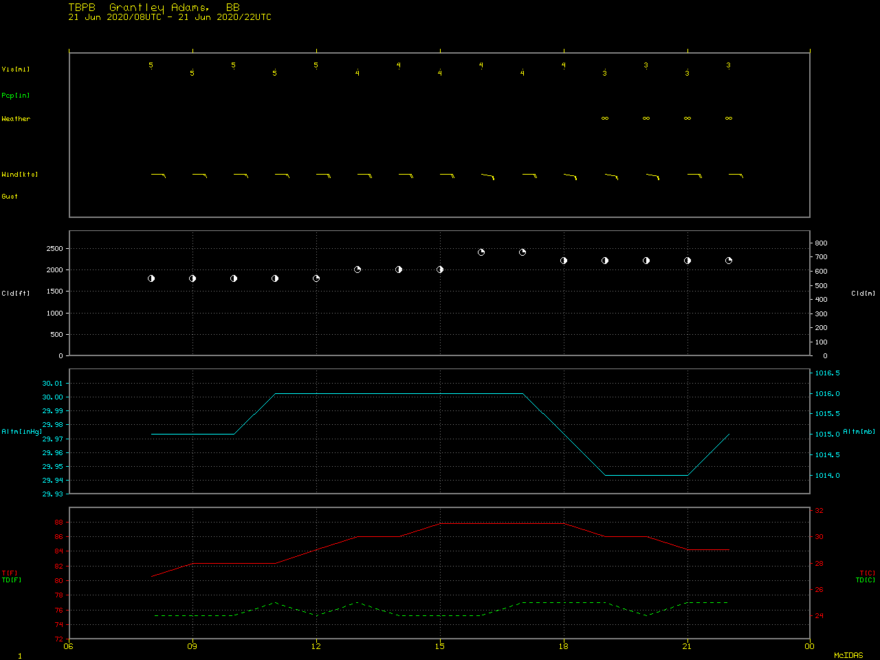
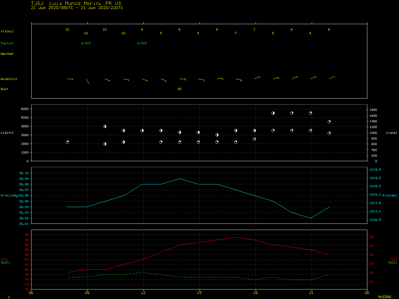
A closer look at GOES-16 Split Window Difference and AOD images centered over Puerto Rico (below) revealed that the surface visibility was reduced to 3 miles at two sites in eastern Puerto Rico — and an AOD value of 2.0 was noted just south of San Juan TJSJ at 2201 UTC. The visibility was further reduced to 2-3 miles at nearby islands.
![GOES-16 Split Window Difference (10.3 µm – 12.3 µm) and Aerosol Optical Depth images, with surface reports plotted in white [click to play animation | MP4]](https://cimss.ssec.wisc.edu/satellite-blog/images/2020/06/200622_goes16_splitWindowDifference_aerosolOpticalDepth_Saharan_Air_Layer_dust_Puerto_Rico_anim.gif)
GOES-16 Split Window Difference (10.3 µm – 12.3 µm) and Aerosol Optical Depth images, with surface reports plotted in white [click to play animation | MP4]
The visibility in San Juan, PR, was 3 miles for a while today due to Sahara Desert dust. Looking at the Local Climatological Data (LCD) files from the San Juan airport, there are no cases of sub–4 mile visibility since the early 1950s due to Haze in the summer months.
— Brian Brettschneider (@Climatologist49) June 23, 2020
GOES-16 True Color RGB images (below) depicted the thick plume of dust.
![GOES-16 True Color RGB images [click to play animation | MP4]](https://cimss.ssec.wisc.edu/satellite-blog/images/2020/06/200622_goes16_trueColorRGB_Saharan_Air_Layer_dust_anim.gif)
GOES-16 True Color RGB images [click to play animation | MP4]
![GOES-16 Split Window Difference "Saharan Air Layer product", 13-22 June [click to play animation | MP4]](https://cimss.ssec.wisc.edu/satellite-blog/images/2020/06/200613_200622_goes16_Saharan_Air_Layer_anim.gif)
GOES-16 Split Window Difference “Saharan Air Layer product”, 13-22 June [click to play animation | MP4]
===== 24 June Update =====
![GOES-16 True Color RGB (daytime) and Dust RGB (nighttime) images, 08-24 June [click to play MP4 animation]](https://cimss.ssec.wisc.edu/satellite-blog/images/2020/06/GOES-16_ABI_RadF_true_color_night_dust_2020176_160020Z.png)
GOES-16 True Color RGB (daytime) and Dust RGB (nighttime) images, 08-24 June (credit: Tim Schmit, ASPB/CIMSS) [click to play MP4 animation]
A 12-day animation of GOES-16 Split Window Difference “Saharan Air Layer product” covering the period 13-24 June (below) also displayed the primary SAL plume reaching the Gulf of Mexico on 24 June, in addition to the secondary SAL plume emerging on 22-23 June.
![GOES-16 Split Window Difference "Saharan Air Layer product", 13-24 June [click to play animation | MP4]](https://cimss.ssec.wisc.edu/satellite-blog/images/2020/06/20200619.21.NWAtlantic.SALgoes16split.png)
GOES-16 Split Window Difference “Saharan Air Layer product”, 13-24 June [click to play animation | MP4]