Testing of GOES-16 and GOES-17 Mode 6 scan strategy
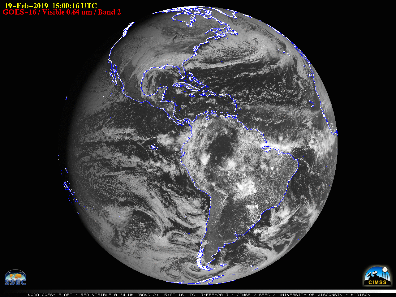
GOES-16 “Red” Visible (0.64 µm) images [click to play animation]
![GOES-16 Mid-level Water Vapor (6.9 µm) images [click to play animation]](https://cimss.ssec.wisc.edu/satellite-blog/wp-content/uploads/sites/5/2019/02/190219_goes16_waterVapor_Full_Disk_anim.gif)
GOES-16 Mid-level Water Vapor (6.9 µm) images [click to play animation]
![GOES-16 "Red" Visible (0.64 µm) and Mid-level Water Vapor (6.9 µm) images [click to play animation]](https://cimss.ssec.wisc.edu/satellite-blog/wp-content/uploads/sites/5/2019/02/190219_goes16_visible_waterVapor_Atlantic_low_anim.gif)
GOES-16 “Red” Visible (0.64 µm) and Mid-level Water Vapor (6.9 µm) images [click to play animation]
![GOES-16 Air Mass RGB images [click to play animation | MP4]](https://cimss.ssec.wisc.edu/satellite-blog/wp-content/uploads/sites/5/2019/02/190219_goes16_airmassRGB_anim.gif)
GOES-16 Air Mass RGB images [click to play animation | MP4]
![GOES-17 "Red" Visible (0.64 µm) images [click to play animation]](https://cimss.ssec.wisc.edu/satellite-blog/wp-content/uploads/sites/5/2019/02/190219_goes17_visible_Full_Disk_anim.gif)
GOES-17 “Red” Visible (0.64 µm) images [click to play animation]
![GOES-17 Mid-level Water Vapor (6.9 µm) images [click to play animation]](https://cimss.ssec.wisc.edu/satellite-blog/wp-content/uploads/sites/5/2019/02/190219_goes17_waterVapor_Full_Disk_anim.gif)
GOES-17 Mid-level Water Vapor (6.9 µm) images [click to play animation]
![GOES-17 Low-level (7.3 µm) and Mid-level (6.9 µm) Water Vapor images [click to play animation]](https://cimss.ssec.wisc.edu/satellite-blog/wp-content/uploads/sites/5/2019/02/190219_goes17_waterVapor_Aleutians_anim.gif)
GOES-17 Low-level (7.3 µm, left) and Mid-level (6.9 µm, right) Water Vapor images [click to play animation]
![GOES-17 Air Mass RGB images [click to play animation | MP4]](https://cimss.ssec.wisc.edu/satellite-blog/wp-content/uploads/sites/5/2019/02/190219_goes17_airmassRGB_Alaska_anim.gif)
GOES-17 Air Mass RGB images [click to play animation | MP4]