Comparisons of GOES-15, GOES-16 and GOES-17
![Visible images from GOES-15 (0.63 µm, left), GOES-17 (0.64 µm, center) and GOES-16 (0.64 µm, right) [click to play animation | MP4]](https://cimss.ssec.wisc.edu/satellite-blog/wp-content/uploads/sites/5/2018/07/180717_goes15_goes17_goes16_visible_PacNW_anim.gif)
Visible images from GOES-15 (0.63 µm, left), GOES-17 (0.64 µm, center) and GOES-16 (0.64 µm, right) [click to play animation | MP4]
* GOES-17 imagery shown here are preliminary and non-operational *
A 3-panel comparison of Visible images from GOES-15 (GOES-West), GOES-17 and GOES-16 (GOES-East) shown above highlights the dissipation of fog in the Strait of Juan de Fuca during the morning hours on 17 July 2018. The three sets of images are displayed in the native projection of each satellite (with no re-mapping) — GOES-17 was at its post-launch checkout location of 89.5ºW longitude. Images from GOES-16/17 were at 5-minute intervals, while images from GOES-15 were every 5-15 minutes depending on the operational scan schedule of that GOES-West satellite.
A similar 3-satellite comparison shown below focuses on the development of showers and thunderstorms across western Montana, between Missoula KMSO and Butte KBTM. The improved spatial resolution (0.5 km at satellite sub-point for GOES-16/17, vs 1.0 km for GOES-15) and more frequent images allowed small-scale features of the storms to be more easily identified and followed.
![Visible images from GOES-15 (0.63 µm, left), GOES-17 (0.64 µm, center) and GOES-16 (0.64 µm, right) [click to play animation | MP4]](https://cimss.ssec.wisc.edu/satellite-blog/wp-content/uploads/sites/5/2018/07/180717_goes15_goes17_goes16_visible_Montana_convection_anim.gif)
Visible images from GOES-15 (0.63 µm, left), GOES-17 (0.64 µm, center) and GOES-16 (0.64 µm, right) [click to play animation | MP4]
![Visible images from GOES-15 (0.63 µm, left), GOES-17 (0.64 µm, center) and GOES-16 (0.64 µm, right) [click to play animation | MP4]](https://cimss.ssec.wisc.edu/satellite-blog/wp-content/uploads/sites/5/2018/07/180717_goes15_goes17_goes16_visible_CO_severe_anim.gif)
Visible images from GOES-15 (0.63 µm, left), GOES-17 (0.64 µm, center) and GOES-16 (0.64 µm, right) — SPC storm reports of wind are plotted in red [click to play animation | MP4]
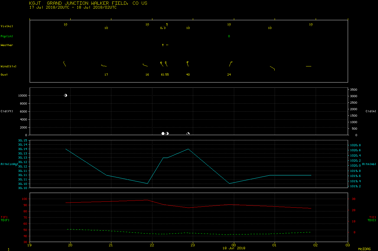
Yesterday’s peak wind gust of 70 MPH at the @GJAirport set a new record wind speed for the month of July, breaking the old record of 68 MPH set on July 14, 2002! #cowx #climate
— NWS Grand Junction (@NWSGJT) July 18, 2018