Isolated cirrus cloud feature over Louisiana
![GOES-16 Visible (0.64 µm) images, with surface station identifiers plotted in yellow [click to play MP4 animation]](https://cimss.ssec.wisc.edu/satellite-blog/wp-content/uploads/sites/5/2017/11/960x1280_AGOES16_B2_G16_VIS_TX_CIRRUS_10NOV2017_2017314_170219_0001PANEL.GIF)
GOES-16 Visible (0.64 µm) images, with surface station identifiers plotted in yellow [click to play MP4 animation]
An isolated cloud feature moving east-southeastward across Louisiana on 10 November 2017 caught the attention of several people on Twitter — GOES-16 “Red” Visible (0.64 µm) images (above) showed the motion of this cloud during the 1317-2052 UTC period.
In a 3-panel comparison of GOES-16 “Red” Visible (0.64 µm), Near-Infrared “Cirrus” (1.37 µm) and “Clean” Infrared Window (10.3 µm) images (below), the strong signature (bright white) on the 1.37 µm imagery indicated that this feature was a cirrus cloud. The uncharacteristically-warm Infrared brightness temperatures exhibited by this feature were due to the fact that the thin cirrus allowed warmer thermal radiation from the surface to pass through the cloud and reach the satellite detectors.
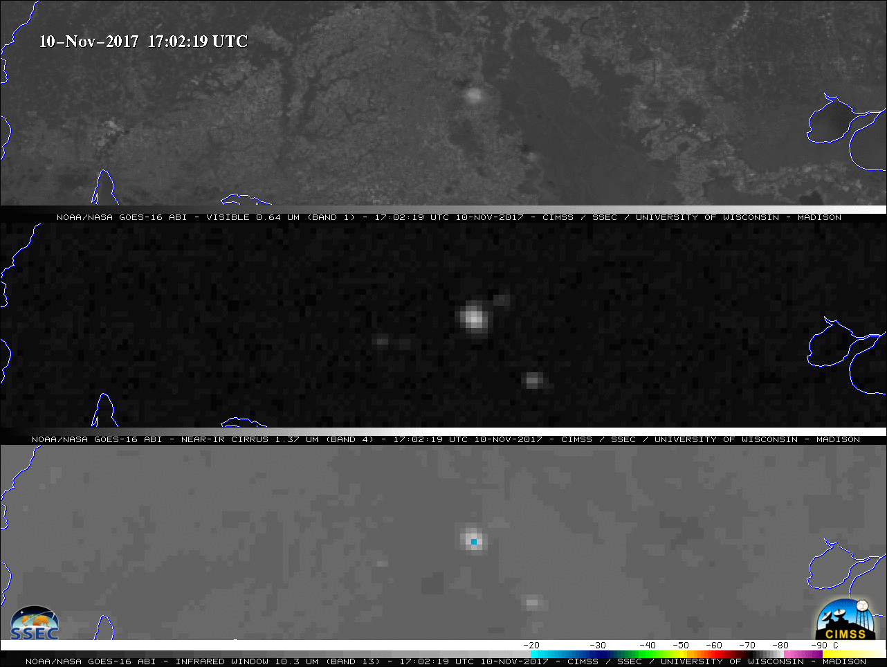
GOES-16 Visible (0.64 µm, top), Near-Infrared “Cirrus” (1.37 µm, middle) and “Clean” Infrared Window (10.3 µm, bottom) images [click to play MP4 animation]
![Rawinsonde data for Lake Charles and Slidell, Louisiana at 12 UTC on 10 November [click to enlarge]](https://cimss.ssec.wisc.edu/satellite-blog/wp-content/uploads/sites/5/2017/11/171110_12UTC_LCH_LIX_RAOBS.GIF)
Rawinsonde data for Lake Charles and Slidell, Louisiana at 12 UTC on 10 November [click to enlarge]
![Terra MODIS Visible (0.65 µm), Cirrus (1.375 µm) and Infrared Window (11.0 µm) images [click to enlarge]](https://cimss.ssec.wisc.edu/satellite-blog/wp-content/uploads/sites/5/2017/11/171110_1644utc_terra_modis_visible_cirrus_infrared_LA_cirrus_anim.gif)
Terra MODIS Visible (0.65 µm), Cirrus (1.375 µm) and Infrared Window (11.0 µm) images [click to enlarge]
![Terra MODIS Visible (0.65 µm) image and Land Surface Temperature product [click to enlarge]](https://cimss.ssec.wisc.edu/satellite-blog/wp-content/uploads/sites/5/2017/11/171110_1644utc_terra_modis_Visible_LandSurfaceTemperature_LA_cirrus_anim.gif)
Terra MODIS Visible (0.65 µm) image and Land Surface Temperature product [click to enlarge]