Hurricane Olaf
Advanced Dvorak Technique (ADT) intensity estimate plot for Hurricane Olaf
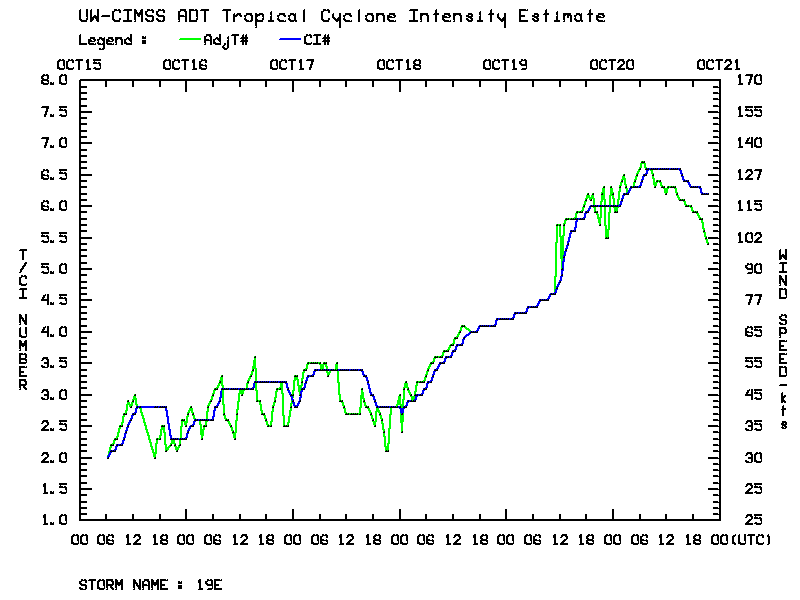
A plot of the Advanced Dvorak Technique (ADT) intensity estimate for Hurricane Olaf (above) showed that the storm went through a period of rapid intensification during the 19-20 October 2015 period, reaching Category 4 strength. The National Hurricane Center noted that Olaf became the 6th major hurricane in the eastern North Pacific during the 2015 season, and that this was is the farthest south (9.9º N latitude) that a major hurricane had formed in that ocean basin since reliable records began in 1971 (discussion archive: NHC | CPHC).
4-km resolution GOES-15 (GOES-West) 10.7 µm Infrared channel images during the period of rapid intensification (below) revealed that cloud-top IR brightness temperatures were quite cold (in the -80º to -90º C range, violet colors) early in the day on 19 October, but then warmed a bit into the -70º to -80º C range (black to white shades) on 20 October as the eye became more well-defined.
![GOES-15 Infrared (10.7 µm) images [click to play animation]](https://cimss.ssec.wisc.edu/satellite-blog/wp-content/uploads/sites/5/2015/10/151019-20_goes15_ir_Hurricane_Olaf_anim.gif)
GOES-15 Infrared (10.7 µm) images [click to play animation]
![Suomi NPP VIIRS Infrared (11.45 µm) image [click to enlarge]](https://cimss.ssec.wisc.edu/satellite-blog/wp-content/uploads/sites/5/2015/10/151020_1023utc_suomi_npp_viirs_ir_Hurricane_Olaf.png)
Suomi NPP VIIRS Infrared (11.45 µm) image [click to enlarge]