Plane crash in Sao Paulo, Brazil
The worst airline disaster in Brazil’s history occurred on the evening of 17 July 2007 as a TAM Airlines Airbus A320 was attempting to land at the Congonhas airport in Sao Paulo, Brazil. Early media reports (CNN) indicated that the plane was landing during a “driving rainstorm”, which led us to take a look at GOES-10 satellite imagery to examine the meteorological conditions leading up to the crash. However, GOES-10 10.7µm InfraRed (IR) imagery (above; Java animation) suggests that only light (to possibly moderate) rain might have been falling from the comparatively warm cloud top brightness temperatures (-30 to -40º C, dark blue to green enhancement) seen in the vicinity of Sao Paulo (station identifier SBSP) — the closest area of significantly cold cloud top temperatures (-60 to -70º C, red to black enhancement) indicative of heavy to severe convective rainfall was still far to the west of SBSP over interior southern Brazil at that time.
Indeed, a time series of surface observations or “meteorogram” from SBSP (below) showed only light rain which was reducing surface visibility to 4-7 miles during the hours leading up to the crash at 21:50 UTC (18:50 local time). The rainfall was likely a factor in contributing to this particular tragedy, but it is important to note that the relatively short runway that was used (which had just been resurfaced in June 2007) had not yet been grooved to facilitate water run-off and prevent hydroplaning — other media reports (BBC) also stated that two additional smaller planes had skidded off that same runway only a day before the 17 July accident.
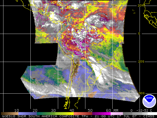
The extensive cloud cover across much of southern Brazil prevented GOES-10 sounder retrievals necessary for the generation of Total Precipitable Water (TPW) Derived Product Imagery (below), which may have offered an additional clue as to the precipitation potential of any convective activity in the Sao Paulo region that day.


