Hurricane-Force low over the Aleutian Islands
![Water Vapor images from GOES-17 (6.9 µm, left) and GOES-15 (6.5 µm, right) [click to play animation | MP4]](https://cimss.ssec.wisc.edu/satellite-blog/wp-content/uploads/sites/5/2018/12/181228_181229_goes17_goes15_waterVapor_Aleutian_Islands_HF_low_anim.gif)
Water Vapor images from GOES-17 (6.9 µm, left) and GOES-15 (6.5 µm, right) [click to play animation | MP4]
* GOES-17 images shown here are preliminary and non-operational *
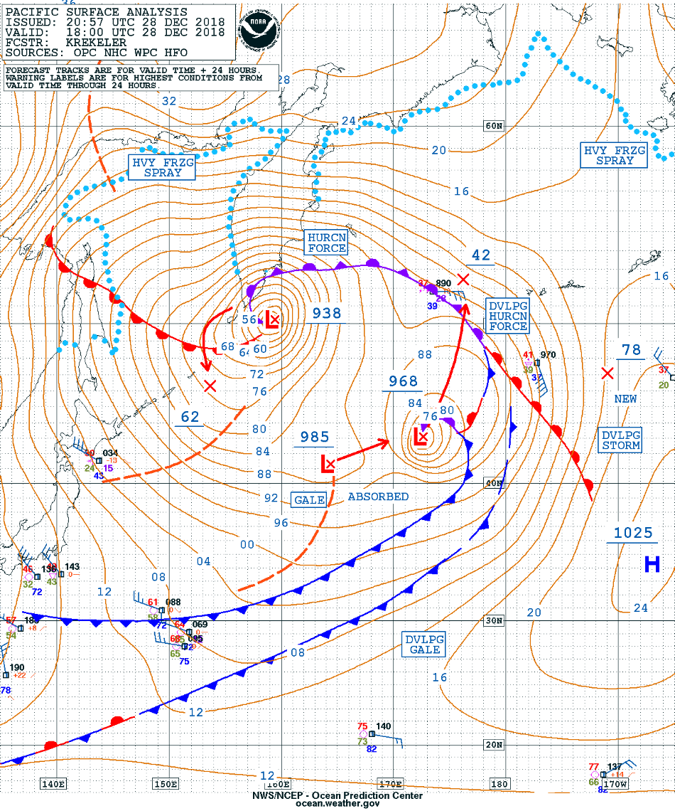
A mid-latitude cyclone moved northward over the far western Aleutian Islands late in the day on 28 December 2018, intensifying to a Hurricane Force low pressure system by 06 UTC on 29 December (surface analyses). A comparison of GOES-17 and GOES-15 (GOES-West) Water Vapor images (above) highlighted the improved spatial resolution of the GOES-17 data (2 km at satellite sub-point, vs 4 km for GOES-15). The view from GOES-15 was more oblique, since it was positioned at 128º W longitude (compared to 137.2º W longitude for GOES-17). GOES-17 is scheduled to become the operational GOES-West satellite in January 2019.
A toggle between GOES-17 Low-level (7.3 µm), Mid-level (6.9 µm) and Upper-level (6.2 µm) Water Vapor images at 1100 UTC is shown below. Although the satellite viewing angle was large, good detail could still be seen.
![GOES-17 Low-level (7.3 µm), Mid-level (6.9 µm) and Upper-level (6.2 µm) Water Vapor images at 1100 UTC [click to enlarge]](https://cimss.ssec.wisc.edu/satellite-blog/wp-content/uploads/sites/5/2018/12/18129_1100utc_goes17_waterVapor_Aleutian_Islands_anim.gif)
GOES-17 Low-level (7.3 µm), Mid-level (6.9 µm) and Upper-level (6.2 µm) Water Vapor images at 1100 UTC [click to enlarge]
![Suomi NPP VIIRS Visible (0.64 µm), Day/Night Band (0.7 µm) and Infrared Window (11.45 µm) images [click to enlarge]](https://cimss.ssec.wisc.edu/satellite-blog/wp-content/uploads/sites/5/2018/12/181229_suomiNPP_viirs_visible_dayNightBand_infrared_Aleutian_Islands_anim.gif)
Suomi NPP VIIRS Visible (0.64 µm), Day/Night Band (0.7 µm) and Infrared Window (11.45 µm) images [click to enlarge]
![Time series plot of surface weather data from Shemya Eareckson Air Station [click to enlarge]](https://cimss.ssec.wisc.edu/satellite-blog/wp-content/uploads/sites/5/2018/12/181228_181229_PASY_SFCMG.GIF)
Time series plot of Hourly surface weather data from Shemya Eareckson Air Station [click to enlarge]
![Time series plot of Hourly and Special surface weather data from Shemya Eareckson Air Station [click to enlarge]](https://cimss.ssec.wisc.edu/satellite-blog/wp-content/uploads/sites/5/2018/12/181229_PASY_SFCMG.GIF)
Time series plot of Hourly and Special surface weather data from Shemya Eareckson Air Station [click to enlarge]