Fog/stratus in the Strait of Juan de Fuca
Frequent images we obtain from #GOES16 show motion in the atmosphere nicely. Here’s a great loop of fog in the Strait this evening. #wawx pic.twitter.com/f0HI1yS8ab
— NWS Seattle (@NWSSeattle) May 21, 2017
** The GOES-16 data posted on this page are preliminary, non-operational data and are undergoing testing. **
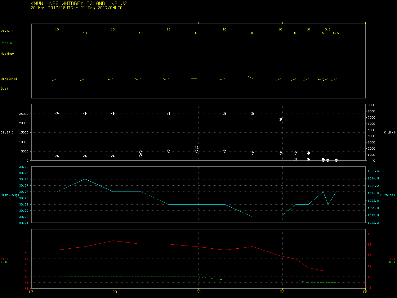
As seen in a Tweet from NWS Seattle/Tacoma (above), a plume of fog/stratus moved rapidly eastward through the Strait of Juan de Fuca on 20 May 2017. A closer view of GOES-16 Visible (0.64 µm) images (below; also available as an MP4 animation) shows the formation of “bow shock waves” as the leading edge of the low-level fog/stratus plume encountered the sharply-angled land surface of Whidbey Island at the far eastern end of the Strait near sunset — surface observations indicated that the visibility at Naval Air Station Whidbey Island was reduced to 0.5 mile just after the time of the final 0327 UTC image in the animation.
![GOES-16 Visible (0.64 µm) images, with hourly plots of surface reports [click to play animation]](https://cimss.ssec.wisc.edu/satellite-blog/wp-content/uploads/sites/5/2017/05/170520_goes16_visible_WA_fog_anim.gif)
GOES-16 Visible (0.64 µm) images, with hourly plots of surface reports [click to play animation]
![Suomi NPP VIIRS Visible (0.64 µm) images, with RTMA surface winds plotted in cyan [click to enlarge]](https://cimss.ssec.wisc.edu/satellite-blog/wp-content/uploads/sites/5/2017/05/170520_2054utc_viirs_visible_rtma_surface_winds_WA_strait_fog_stratus_anim.gif)
Suomi NPP VIIRS Visible (0.64 µm) images, with RTMA surface winds plotted in cyan [click to enlarge]
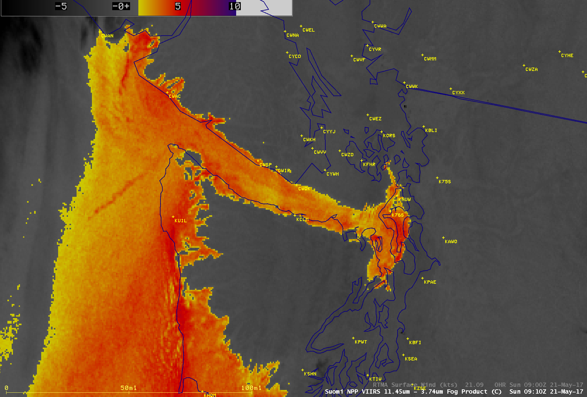
Suomi NPP VIIRS infrared Brightness Temperature Difference (11.45 – 3.74 µm) “Fog/Stratus Product” image, with RTMA surface winds plotted in cyan [click to enlarge]
In the absence of visible imagery at night, evolution of fog is depicted well in #GOES16 fog difference. #wawx From: https://t.co/1tH0TQCKm3 pic.twitter.com/j6lMd4tDMa
— Bill Line (@bill_line) May 22, 2017
On a side note, in the upper right portion of the GOES-16 (as well as the VIIRS) visible images one can also see the hazy signature of glacial sediment flowing from the Fraser River westward into the Strait of Georgia. Longer-term changes in the pattern of this glacial sediment are also apparent in a comparison of Terra MODIS true-color Red/Green/Blue (RGB) images (source) from 20 April, 07 May and 20 May 2017 (below).
![Terra MODIS true-color RGB images [click to enlarge]](https://cimss.ssec.wisc.edu/satellite-blog/wp-content/uploads/sites/5/2017/05/170421_170520_modis_truecolor_Fraser_River_BC_sediment_anim.gif)
Terra MODIS true-color RGB images [click to enlarge]