Tornado in Lake Geneva, Wisconsin
![GOES-14 (left) and GOES-13 (right) 10.7 µm IR images. Lake Geneva Wisconsin is indicated by the small white box [click to play animated GIF]](https://cimss.ssec.wisc.edu/satellite-blog/wp-content/uploads/sites/5/2015/08/GOES14GOES13_LAKEGENEVA_19AUGUST2015_0125-0230anim.gif)
GOES-14 (left) and GOES-13 (right) 10.7 µm IR images. Lake Geneva Wisconsin is indicated by the small white box [click to play animated GIF]
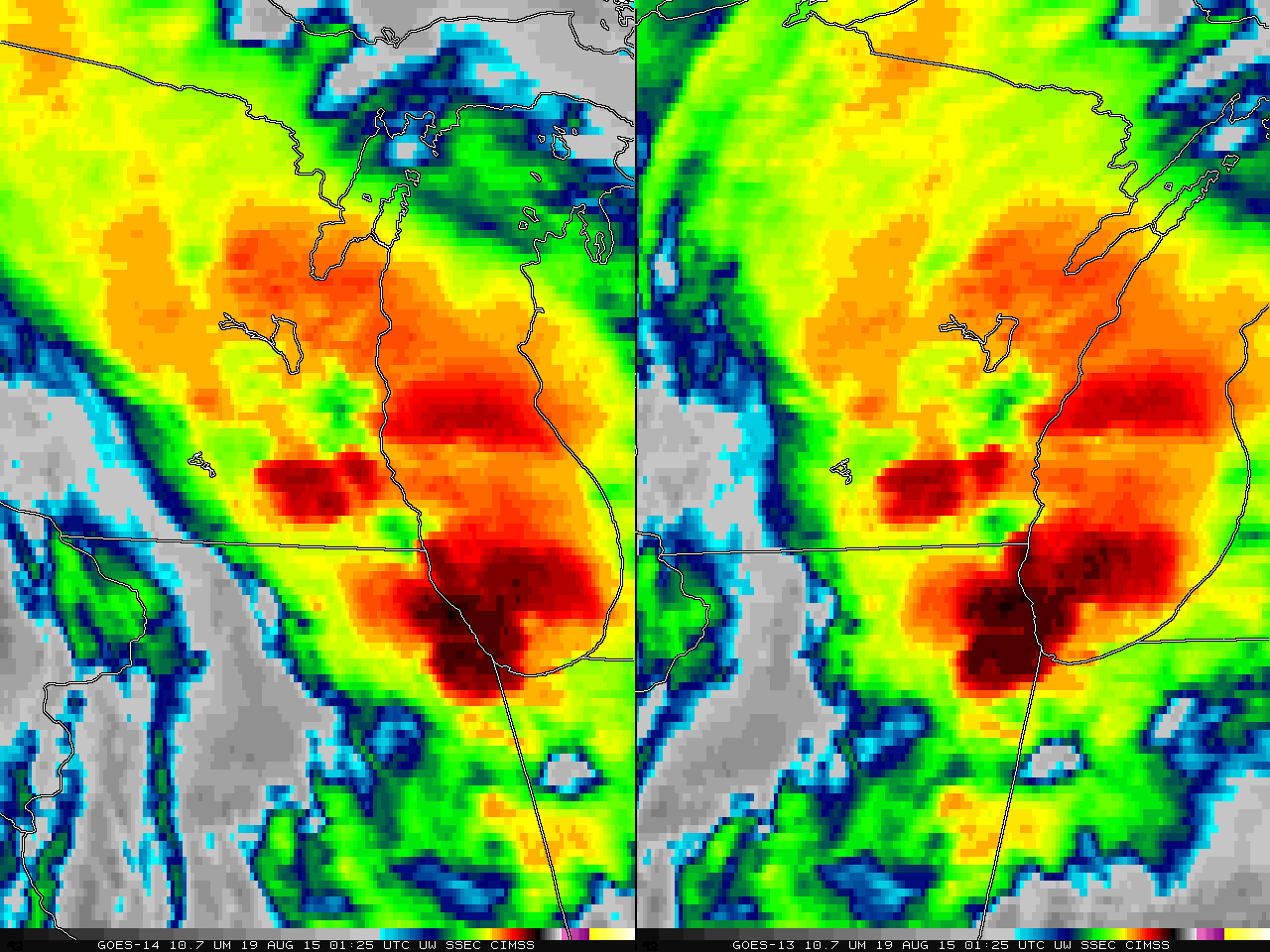
An EF-1 Tornado struck Lake Geneva, WI after sunset on 18 August 2015 (SPC Storm Reports; NWS MKX report). GOES-14 was in SRSO-R mode, providing 1-minute imagery over the region; additionally, GOES-13 was in RSO mode, providing imagery about every 7 minutes. Unfortunately, GOES-14 requires two 15-minute breaks in scanning to perform housekeeping (Link); one of those periods is from 0130-0145 UTC, 13 minutes before the tornado touchdown at 0158 UTC. (GOES-R will not require these 15-minute breaks). The animation above pauses during that housekeeping time; it also slows for the ten minutes surrounding 0158 UTC. (Click here for an animation without the White Box signifying Lake Geneva).
The 0158 UTC imagery from GOES-14 (paired with the 0155 UTC imagery from GOES-13 is shown below. An overshooting top that is associated with the tornado is apparent (northeast of Lake Geneva because of the parallax shift). This overshoot is easily traceable in the 1-minute imagery, above, as it moves northeastward towards Lake Michigan. The feature also appears and can be tracked in GOES-13.
![GOES-14 (left) and GOES-13 (right) 10.7 µm IR images, 0158 UTC 19 August 2015. Lake Geneva Wisconsin is indicated by the small white box [click to enlarge]](https://cimss.ssec.wisc.edu/satellite-blog/wp-content/uploads/sites/5/2015/08/GOES14GOES13_LAKEGENEVA_19AUGUST2015_0158.GIF)
GOES-14 (left) and GOES-13 (right) 10.7 µm IR images. Lake Geneva Wisconsin is indicated by the small white box [click to enlarge]
Automated detection of Overshooting Tops (and thermal couplets) (from this website) showed a cluster of Overshooting Tops moving over southeast Wisconsin at the time of the tornado. The number of Overshoots detected jumped about an hour before the tornado touchdown.
![GOES-13 Automated Detection of Overshooting Tops (blue) and Thermal Couplets (Red) 2330 UTC 18 August 2015 - 0225 19 August 2015 [click to enlarge]](https://cimss.ssec.wisc.edu/satellite-blog/wp-content/uploads/sites/5/2015/08/overtop_east_20150818_2330_20150819_0215UTCanim.gif)
GOES-13 Automated Detection of Overshooting Tops (blue) and Thermal Couplets (Red) 2330 UTC 18 August 2015 – 0225 19 August 2015 [click to enlarge]