Satellite Technology
Satellites are launched on spacecrafts which are significantly larger than their scientific payload, requiring rocket fuel to reach outer space. Once the satellite disengages, solar panels open to power sensors and navigation features indefinitely. Newton's law of gravity and Kepler's laws of motion keeps satellites on course.
The sensors that measure electromagnetic energy are called radiometers. We'll focus on two kinds of scanning radiometers designed to detect electromagnetic radiation in discrete wavelengths: imagers and sounders. "Imagers" result in the striking images seen on television or the Internet. Imagers can either measure visible sunlight reflected back to space from the Earth's surface and clouds or the amount of radiation emitted by features on Earth. The output voltage from a particular radiometer detector is proportional to the energy striking that detector area per unit time. On a satellite image, each pixel is assigned a shade according to the energy measured. "Sounder" is a shorter name for Vertical Atmospheric Sounder (VAS), but don't let this name mislead you, these radiometers measure infrared radiation, not sound waves. Sounders provide vertical profiles of temperature, pressure, water vapor and critical trace gases in Earth's atmosphere. Trace gas profiles such as carbon dioxide or ozone are important for climate studies while temperature, water vapor and pressure information are crucial to forecasting severe weather.
Satellite Orbits
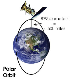
There are two main satellite orbits: Low Earth Orbiting Satellites or LEO and Geostationary Earth Orbiting Satellites or GEO. Most satellite images seen on the local television news are produced by GEO satellites which orbit the earth above the equator at the same speed as the earth rotates in order to transmit a continuous picture of the region below. LEO satellites, often called polar orbiters, fly lower and nearly perpendicular paths to GEO orbits, traveling from pole to pole taking "snapshots" of Earth rotating below.
GEO Satellites | |
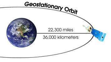
|
To maintain constant height and momentum, a geostationary satellite must be located over the equator. The United States typically operates two geostationary satellites called GOES or Geostationary Operational Environment Satellites. One has a good view of the East Coast; the other is focused on the West Coast. Other countries operate GEO satellite systems and scientists traditionally share data freely. |
| LEO Satellites POES missions are managed by the National Oceanic and Atmospheric Administration (NOAA). The National Aeronautic and Space Administration (NASA) manages a series of low Earth orbiting research satellites called Earth Observing Satellites (EOS). |
 |
The next U.S. polar orbiting satellite program is slated to be a tri-agency program with contributions from NOAA, NASA and the Department of Defense. |