Meteorology » Identifying Clouds on Satellite Images
Learn how to indentify clouds on satellite images by working through the following activities:
 1. The visible satellite image to the right from May 2002 shows clouds over the upper plains area of Canada. Can you identify which clouds are low-level stratus clouds and which ones are high cirrus clouds?
Click on the image to the right to begin the activity.
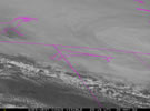
 2. Can
you identify the cloud types in this image of satellite data taken over northeastern
North America on 5/31/02?
2. Can
you identify the cloud types in this image of satellite data taken over northeastern
North America on 5/31/02?
Click on the image to the right to begin the activity.