Meteorology » Global Weather Patterns
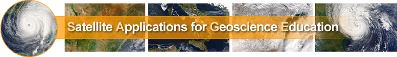
The Intertropical Convergent Zone (ITZC)
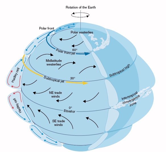
The ITZC is a ubiquitous band of clouds that encircles the tropics near the equator. These convective clouds are visible because water vapor in rising air is condensing into tiny droplets of liquid water in the air currents. The steady supply of rising air comes from winds constantly converging from both the northern and southern hemispheres at the surface. Heat from the Sun also aids this process so the ITCZ is stronger and more noticeable during the day. The ITCZ shifts with the seasons, moving pole-ward in spring and equator-ward in autumn while generally staying within a few degrees of the equator year-round.
|
Click on the image to enlarge
|
Jet Streams
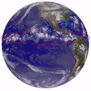
Weather forecasters often discuss the position of the jet stream. You've probably noticed that there is more than one swift "river of air" above us. In fact, there are two main jet streams, the suptropical jet and the polar jet. |
|
 Click on the image to enlarge Click on the image to enlarge
|
Subtropical Jet Stream
Remember the rising air in the ITCZ?
Along with producing cloud and precipitation patterns, this air eventually has to spread northward and southward when it hits the
tropopause, the boundary between the troposphere and the stratosphere. As air flows northward, the Coriolis force turns it to the right and creates a westerly wind in the
upper troposphere between 20 and 30 degrees north latitude. Due to the the conservation of angular momentum, the air picks up speed and forms the subtropical jet, clearly visible on satellite imagery in both hemispheres.
Polar Front Jet Stream
Around 60 degrees north latitude there is a clash of winds separating warm tropical air from cold polar air. This strong temperature gradient results in powerful winds aloft, commonly known as the polar jet. |
Suptropical High
What goes up must come down, and the equatorial air that feeds into the subtropical jet eventually sinks back towards the surface. Since sinking air suppresses clouds and precipitation, large areas of clear skies and light winds can typically be found at around 30 degrees north and south latitude due to air dropping out of the subtropical jets. In fact, there are several semi-permanent high pressure systems over the oceans at these latitudes referred to as subtropical highs. The Bermuda High drifts above the Atlantic ocean. |
Trade Winds
The surface winds curving out around the subtropical highs are called the trade winds which are the prevailing winds in the tropics, blowing predominantly from the northeast in the northern hemisphere and from the southeast in the southern hemisphere. They converge at the ITCZ to start the cycle all over again.
The trade winds are responsible for the initially easterly direction of tropical storms and hurricanes, contrary to the track of most weather systems. When these storms get to the latitude of Florida or Georgia, they reach the mid-latitude westerlies and start to move from the west. As a result, tropical storms commonly approach the southern U.S. from the east at low latitudes before curving around to a westerly direction in middle latitudes. |
|
Click on the image to enlarge
|
Mid-Latitude Westerlies
For most residents of the continental United States the mid-latitude westerlies have the biggest day to day influence on the weather because they are responsible for routinely moving weather systems from west to east across the country. Early weather observers in the 17th and 18th century soon realized that weather systems to their west or north would likely be in their area in the next day or two. Emerging satellite and computer technology in the 20th century enabled daily documentation of this phenomena, along with timely communications for weather forecasting and emergency management.
|