Geology » Volcanoes and Satellite Monitoring
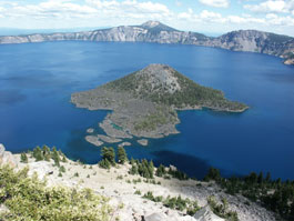
Crater Lake located in southern Oregon; lies within a volcanic caldera created with the collapse of Mount Mazama 7,700 years ago. At over 1,900 feet deep, Crater Lake is the deepest lake in the United States. The small cinder cone located within the lake is named Wizard Island. (Crater Lake National Park)
Volcanic activity is a result of the release of Earth’s interior energy. This release of energy is associated with the build up of stress and heat that can be present at plate boundaries and it can be dangerous when it is released suddenly causing earthquakes, sudden slippage of rock layers, or volcanic eruptions. Besides the more obvious dangers of falling volcanic debris and lava flows for example, volcanic ash clouds can be hazardous to aircraft that may fly through them. As a result it is useful to monitor and track eruption clouds via satellite technology.
In this lesson you will learn:
- Volcanic landforms
- The global distribution of volcanoes
- Volcanic monitoring using satellites
Time requirement
This lesson will take about 45 minutes to complete.