Author Archive

17 April 2007 Flight Status Brief

Tuesday, April 17th, 2007

(From Bob Wells FAAM BAE Operations Manager)

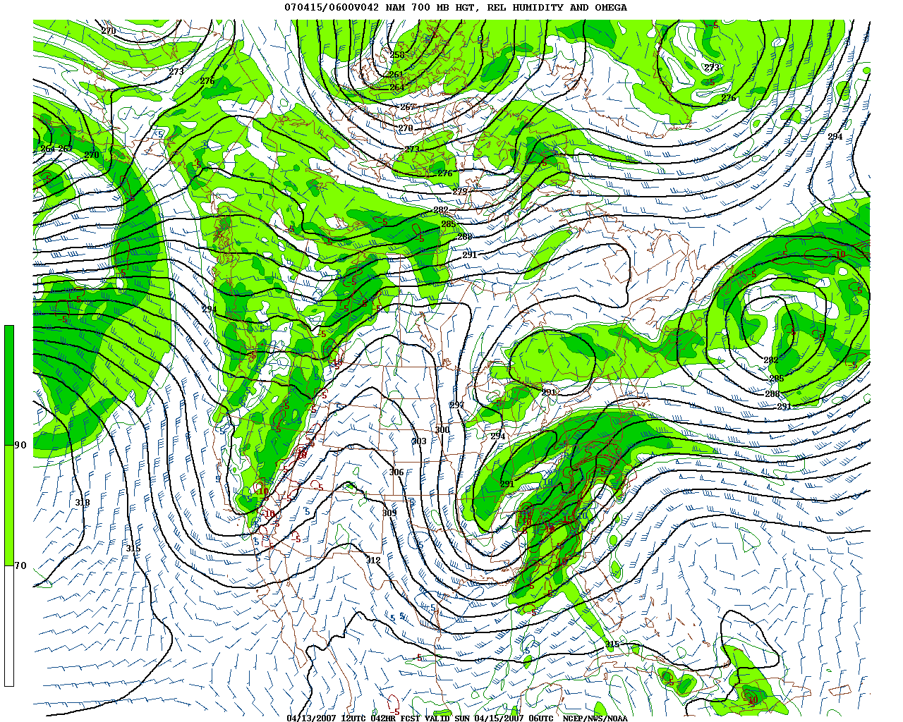
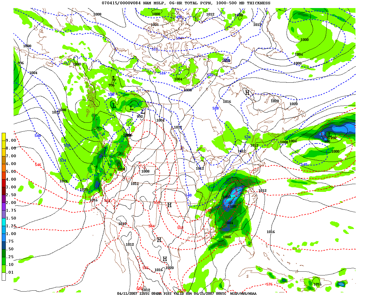
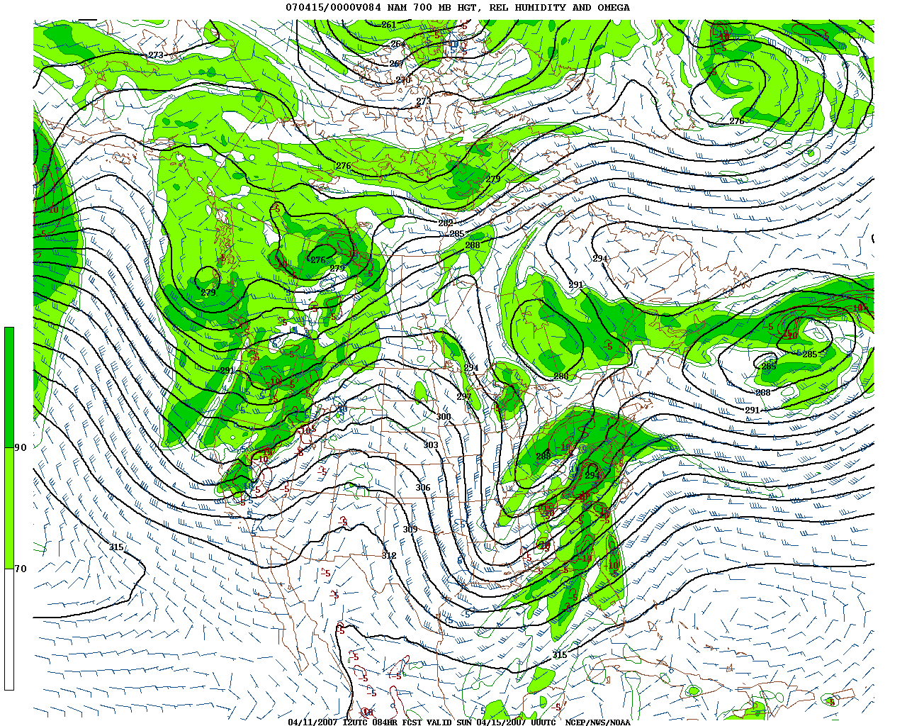
Flight B283 on Monday was very successful. Both the 146 and the WB57 enjoyed clear-sky conditions and positioned under a pass of the AQUA satellite near the ARM ground observatory in Oklahoma.
(The flight track of the WB57 can be found at http://flightaware.com/live/flight/NASA926)

A refuelling stop at Oklahoma City went smoothly.

When performing the pre-flight checks, discovered one of the broadband radiometers full of water. Fortunately he was able to fit a spare sensor for the flight. During the flight the TWC instrument gave an error indication but later, apparently, resumed normal service. The optical discs which record data on the HORACE system gave several problems and are apparently showing the signs of senile dementia.

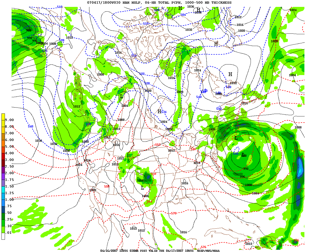
The ground team spent most of the day planning a METOP Pass flight for Tuesday but, late in the day, the flight was cancelled because of the weather forecast (cloud, rain and thunderstorms). Tuesday will therefore be a down day.

(From Allen Larar - WB-57 Scientist)

We appear to have had a
successful flight Monday (20070416), and have canceled the
flight planned for today due to heavy weather likely
over the OK/CART site region.

We had clear sky conditions for our tracks in OK today, and
had both aircraft at or near the CART site during the
Aqua overpass, with nominal instrument operations reported.

Flight Status Update

Monday, April 16th, 2007

Current status (from Allen Larar):

Today (16 Apr). Flight scheduled over CART site, coordinating
with Aqua 1952 GMT overpass. BAE 146 will be flying low-level
runs, ascents/descents, and following a high-altitude s-n line
at time of overpass (CART site ~ center of line). WB-57 takeoff
around 1220 (local) and will be flying at high-altitude same
line with time/space coordination with BAE 146 at overpass
time. Around 30 mins after overpass, a/c will leave the target
area; BAE 146 will RTB while WB-57 will run a line to achieve
clear sky over GOM prior to descent into HOU.

Tues (17 Apr). Flight plan over OK region (a large box with
CART toward eastern side, and Metop sub-satellite toward western
side). Metop overpass is 1636 GMT. This will focus on sampling
a varying clouded environment. We will monitor weather and
IASI scan mode changes and re-consider this flight later.

Wed (18 Apr). Two scenarios under consideration: day flight
catching Metop & Aqua over CART site region, vs night flight
aiming at Metop alone over clear-sky GOM. Decision expected
Tues AM regarding desired option.

Thurs (19 Apr). Night flight over OK to catch both Metop & Aqua
overpasses.

Forecast Discussion - 16 April 1200 - 1600 Local

Monday, April 16th, 2007

Today’s weather over DOE ARM site looks fine. Only fly in ointment is possible cirrus contamination from the southwest. At this point, the mass of clouds remain SE of the area of interest:

http://cimss.ssec.wisc.edu/jaivex/wx-prods/vis.html

but the CRAS forecast indicates the cloudiness will become more extensive with time:

http://cimss.ssec.wisc.edu/model/realtime/cras20_Gulf/cttpn.html

as low develops over the front range of the Rockies over night.

Weather conditions over Oklahoma deteriorate very rapidly overnight with extensive precipitation developing by Noon Local on 17 April 2007:

nam_slp_030l.gif

Flight Status Update….

Monday, April 16th, 2007

Monday’s flight is intended to underfly the 1450 (local) overpass of Aqua in the CART site region (takeoff ~ 1220). Note that we have also added a flight for Tuesday; this is to underfly the 1136 (local) Metop overpass of the CART site region (takeoff ~ 9 AM). (From Allen Larar)

A review of the latest forecast after Sunday’s flight caused the Oklahoma detachment idea to be abandoned (for next week at least). The prospects of unsuitable conditions on Tuesday and Wednesday caused a return to Plan A - an Oklahoma AQUA pass refuel flight on Monday returning to base in Houston in the evening. (From Bob Wells)

Bob Wells FAAM BAE Status report

Sunday, April 15th, 2007

Sunday was much warmer, drier and sunnier than Saturday. Unfortunately it was not really windy enough for the “Houston Plume” flight which was abandoned when little pollution could be detected downwind of the city. (The aircraft had already landed at Ellington Field before any of the ground team realised that all was not well.) However, some useful experience of operating in the area was gained.

Pirouettes on the ground were performed for the Broad Band Radiometers.

The HF radio coverage is poor, especially at low levels, and ATC had advised use of the SATCOM phone, but we were unable to get the phone to work either to or from the aircraft.

The Texan controllers had some problems with the call sign “METMAN”. Mexico is more familiar than meteorology to the Lone Star state and all flights are expected to have a number.

PCASP did not work.

There was a mysterious problem with the communications between the Dry Nephelometer and the laptop which will call into question the reliability of calibration unless it is remedied soon.

The trail of hard caps instead of the hotter, heavier and more clumsy helmets was a great success. Hopefully these can become standard equipment at the earliest opportunity.

A review of the latest forecast after Sunday’s flight caused the Oklahoma detachment idea to be abandoned (for next week at least). The prospects of unsuitable conditions on Tuesday and Wednesday caused a return to Plan A - an Oklahoma AQUA pass refuel flight on Monday returning to base in Houston in the evening.

A Sunday night comms failure at BADC caused delays updating the FAAM web site and uploading data.

Latest Aircraft Status Report

Saturday, April 14th, 2007

14 April 2007

Flight scheduled for tonight is canceled due to undesirable sky conditions expected over the sub-satellite target area. We will have an initial science flight planning meeting Sunday afternoon in preparation for our planned Monday flight; this will be at Southwest Services at 4:30 PM, and is intended to get our thoughts together prior to flight planning with the air crews on Monday AM. Monday’s flight is intended to underfly the 1450 (local) overpass of Aqua in the CART site region (takeoff ~ 1220). Note that we have also added a flight for Tuesday; this is to underfly the 1136 (local) Metop overpass of the CART site region (takeoff ~ 9 AM).

0300 - 0830 UTC 15 April Forecast

Friday, April 13th, 2007

New forecast discussion for first flight opportunity has been posted, BAE is now in Houston.

Forecast Discussion for 0300 - 830 UTC 15 April 2007 N. GOM

Friday, April 13th, 2007

The major weather story is the strong low pressure system in the Southern US and trailing cold front extending through north central GOM.  Strong subsidence will occur in the wake of the cold frontal passage, however the frontal system will be in the area of flight interest during the target time/location domain.  Here is the 42 Hour 700 mb RH and precipitation NAM forecast valid for 6 UTC 15 April (from 12 UTC 13 April run…)

nam_700_042l.gifnam_slp_042l.gif

The situation will have to be monitored tomorrow (Saturday)……

Aircraft Ferry Flight Status

Thursday, April 12th, 2007

BAE and WB-57 are scheduled to arrive today in Houston

Preliminary Forecast for Saturday evening flight

Wednesday, April 11th, 2007

Target area is Northern Gulf of Mexico:

This potential flight opportunity will have to be monitored very carefully for possible extensive cloudiness in N. GOM.

Current 84 hour NAM NWP model run (Valid 00 UTC 15 April 2007) indicate a storm system moving through this area.

84HR NAM valid 00 UTC 15 April 200784HR NAM 700mb RH valid 00 UTC 15 April 2007

The speed of the system may change as potential flight period is approached.  Will update again on Friday 13 April.