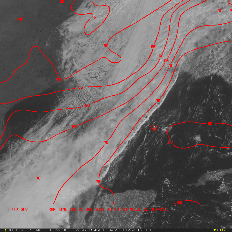
The Wildfire Automated Biomass Burning Algorithm (WFABBA) team produced a 4-day composite of the southern California fires, covering the period 21-24 October 2007. By 26 October, nearly 500,000 acres (~780 square miles) were burned and over 1600 homes were destroyed. The WFABBA product provides frequent, low latency detections and characterizations of fires such as these, as well as the ability to build composites to show the overall development of the fires. Southern California fire activity can be monitored using WFABBA from either GOES-11 or GOES-12.
Archive for October, 2007
4-day composite of the southern California fires
Wednesday, October 24th, 2007California fires: a “smoke signal” in the water vapor imagery?
Tuesday, October 23rd, 2007The large wildfires continued to burn across parts of southern California on 23 October 2007. AWIPS images of the GOES-11 imager visible channel (upper left panel), 6.7 µm water vapor channel (upper right panel), 10.7 µm IR channel (lower left panel), and the GOES-11 Sounder 4.0 µm IR channel (lower right panel) reveal an interesting signature of the smoke pall that had been transported westward out over the Pacific Ocean — on the water vapor channel! Since H2O is a byproduct of combustion, the water vapor content of the aged smoke pall is somewhat elevated compared to the rather dry ambient atmosphere over the eastern Pacific Ocean; this allows a subtle signature of the smoke feature to appear on the GOES imager water vapor channel. There is no signal on either of the IR channel images (bottom 2 panels) since smoke is transparent to thermal radiation at those wavelengths.
A comparison of two 500-meter resolution Terra MODIS red/green/blue (RGB) image composites (above) shows a closer view at the fires in the Los Angeles and San Diego region. The MODIS Channel 01/04/03 RGB image approximates the “true color” images that appear on the SSEC MODIS Direct Broadcast site. The MODIS Channel 07/02/01 RGB image takes advantage of the temperature sensitivity of the “near-IR” Channel 07 (2.1 µm) to make the hottest active fires appear with a pink to red enhancement (the red pixels over water are due to sun glint). The large dark burn scar resulting from the 70,000-acre fire just southwest of San Diego (station identifier KSAN) is just starting to become evident on the 07/02/01 RGB image, even through the thick smoke plume seen on the 04/03/01 RGB image.
The IDEA MODIS aerosol optical depth (AOD) trajectory forecast (above) suggested that some of the thick smoke could get recirculated back over portions of northern California within the 48-hour forecast period; however, the trajectory trend indicated that these aerosols might remain just above the boundary layer, which would limit their impact on surface air quality in the San Francisco region. The National Weather Service also provides a 1-hour average vertical smoke integration product as part of their Air Quality Forecast Guidance.


