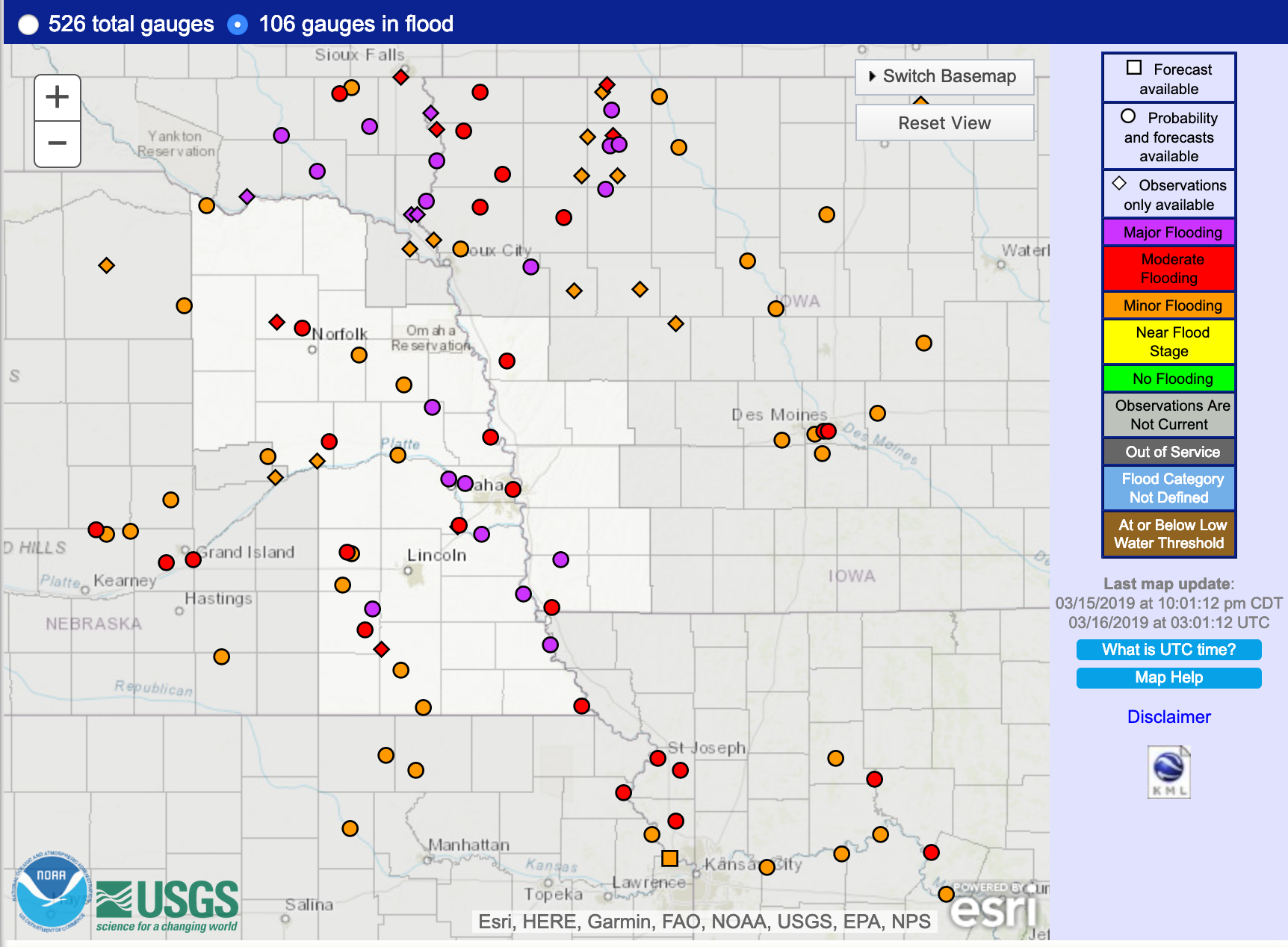
Flooding in South Dakota, Nebraska and Iowa
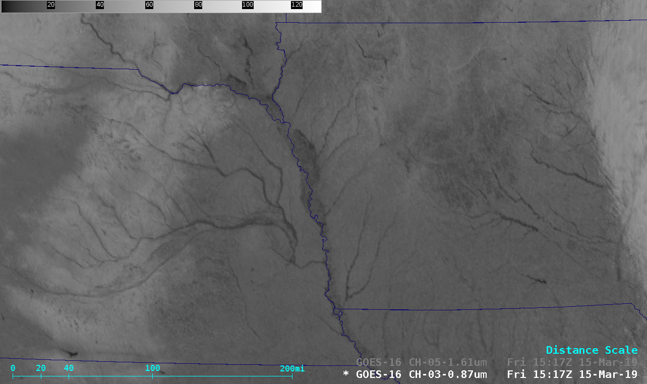
GOES-16 Near-Infrared “Vegetation” (0.86 µm) and “Snow/Ice” (1.61 µm) images [click to play animation | MP4]
In a toggle between Suomi NPP VIIRS Visible (0.64 µm) and “Snow/Ice” (1.61 µm) images at 1821 UTC (below),1.61 µm imagery showed the darker shades of flooding over a north/south portion of Interstate 29 that was closed from State Highway 34 (west of Glenwood, Iowa) to the Iowa/Missouri border (south of Hamburg, Iowa).
![Suomi NPP VIIRS Near-Infrared "Vegetation" (0.86 µm) and "Snow/Ice" (1.61 µm) images [click to enlarge]](https://cimss.ssec.wisc.edu/satellite-blog/wp-content/uploads/sites/5/2019/03/190315_1821utc_suomiNPP_viirs_snowIce_visible_NE_IA_flooding_Interstate29_closure_anim.gif)
Suomi NPP VIIRS Visible (0.64 µm) and “Snow/Ice” (1.61 µm) images; Interstate Highways are plotted in red, while State Highways are plotted in gray [click to enlarge]
![Terra MODIS True Color and False Color RGB images [click to enlarge]](https://cimss.ssec.wisc.edu/satellite-blog/wp-content/uploads/sites/5/2019/03/190315_1720utc_terra_modis_truecolor_falsecolor_NE_flooding_anim.gif)
Terra MODIS True Color and False Color RGB images, centered over eastern Nebraska [click to enlarge]
![Terra MODIS True Color and False Color RGB images, centered near Vermillion, South Dakota [click to enlarge]](https://cimss.ssec.wisc.edu/satellite-blog/wp-content/uploads/sites/5/2019/03/190315_1720utc_terra_modis_truecolor_falsecolor_SD_NE_IA_flooding_anim.gif)
Terra MODIS True Color and False Color RGB images, centered near Vermillion, South Dakota [click to enlarge]
![Terra MODIS True Color and False Color RGB images, centered near Ames, Iowa [click to enlarge]](https://cimss.ssec.wisc.edu/satellite-blog/wp-content/uploads/sites/5/2019/03/190315_1720utc_terra_modis_truecolor_falsecolor_IA_flooding_anim.gif)
Terra MODIS True Color and False Color RGB images, centered near Ames, Iowa [click to enlarge]
===== 16 March Update =====
![Landsat-8 False Color image. centered to the east of Sioux City, Iowa [click to enlarge]](https://cimss.ssec.wisc.edu/satellite-blog/wp-content/uploads/sites/5/2019/03/190316_1706utc_landsat8_falsecolor_Missouri_River_N_anim.gif)
Landsat-8 False Color image centered to the east of Sioux City, Iowa [click to enlarge]
![Landsat-8 False Color image. centered to the south of Omaha, Nebraska [click to enlarge]](https://cimss.ssec.wisc.edu/satellite-blog/wp-content/uploads/sites/5/2019/03/190316_1706utc_landsat8_falsecolor_Missouri_River_S_anim.gif)
Landsat-8 False Color image centered to the south of Omaha, Nebraska [click to enlarge]
![Landsat-8 False Color image. centered at the NWS forecast office in Valley, Nebraska [click to enlarge]](https://cimss.ssec.wisc.edu/satellite-blog/wp-content/uploads/sites/5/2019/03/1903161706utc_landsat8_falsecolor_oax_anim.gif)
Landsat-8 False Color image centered at the NWS forecast office in Valley, Nebraska [click to enlarge]
![Landsat-8 False Color image. centered near Offutt Air Force Base, Nebraska [click to enlarge]](https://cimss.ssec.wisc.edu/satellite-blog/wp-content/uploads/sites/5/2019/03/1903161706utc_landsat8_falsecolor_Offutt_AFB_anim.gif)
Landsat-8 False Color image centered just west of Offutt Air Force Base, Nebraska [click to enlarge]
The #Landsat Dynamic Surface Water Extent (DSWE) science product captured flooding along the Missouri & Platt Rivers in mid-March. These before & after #Landsat8 & DSWE images show the extent of the flooding. DSWE product page: https://t.co/IOfLdcaeNd pic.twitter.com/5dCGwjv3it
— USGS Landsat Program (@USGSLandsat) March 28, 2019