This website works best with a newer web browser such as Chrome, Firefox, Safari or Microsoft Edge. Internet Explorer is not supported by this website.

Tropical Storm Washi (27W) strikes the Philippines

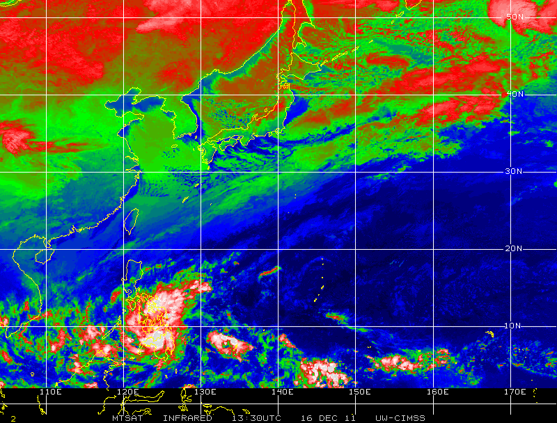
MTSAT-1R 10.8 µm IR images from the CIMSS Tropical Cyclones site (above; click image to play animation) showed a fairly compact cluster of cold convective cloud tops associated with Tropical Storm Washi as it moved westward toward the Philippines during the 15-16 December 2011 period.... Read More

MTSAT-1R 10.8 µm IR images (click image to play animation)

MTSAT-1R 10.8 µm IR images (click image to play animation)

MTSAT-1R 10.8 µm IR images from the CIMSS Tropical Cyclones site (above; click image to play animation) showed a fairly compact cluster of cold convective cloud tops associated with Tropical Storm Washi as it moved westward toward the Philippines during the 15-16 December 2011 period.

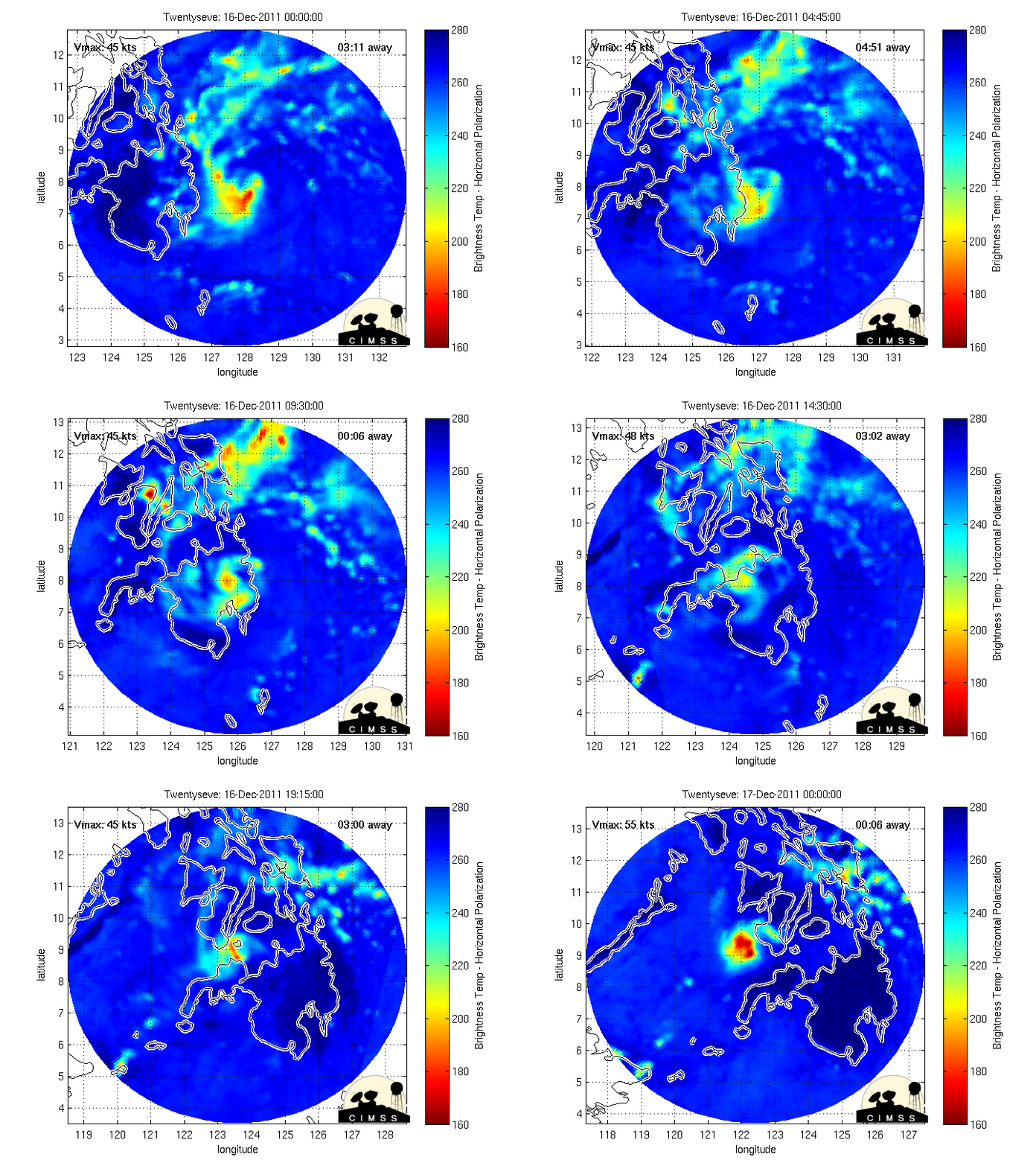
A closer view using MIMIC microwave imagery (below) also showed a relatively small area of enhanced brightness temperatures (representing heavy precipitation) crossing Mindanao Island in the southern Philippines on 16 December.

MIMIC microwave imagery

MIMIC microwave imagery

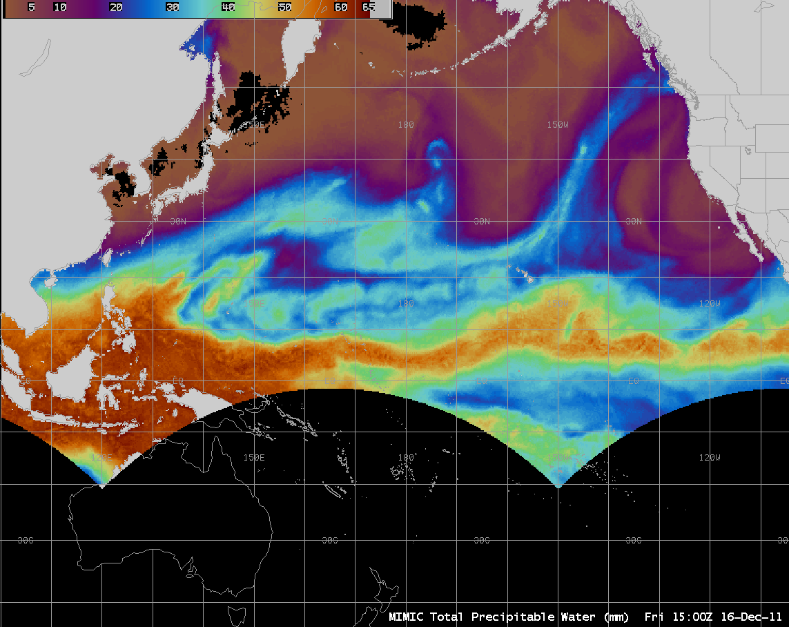
However, AWIPS images of the MIMIC Total Precipitable Water (TPW) product (below; click image to play animation) revealed that Tropical Storm Washi was embedded within a long fetch of very rich tropical moisture, with TPW values in excess of 60 mm or 2.4 inches (darker red color enhancement). This abundance of moisture helped to fuel over 10 hours of heavy rainfall, which resulted in widespread flash flooding and reports of over 900 deaths in the Philippines.

MIMIC Total Precipitable Water product (click image to play animation)

MIMIC Total Precipitable Water product (click image to play animation)

View only this post Read Less

Cloud streets and ice across Hudson Bay, Canada

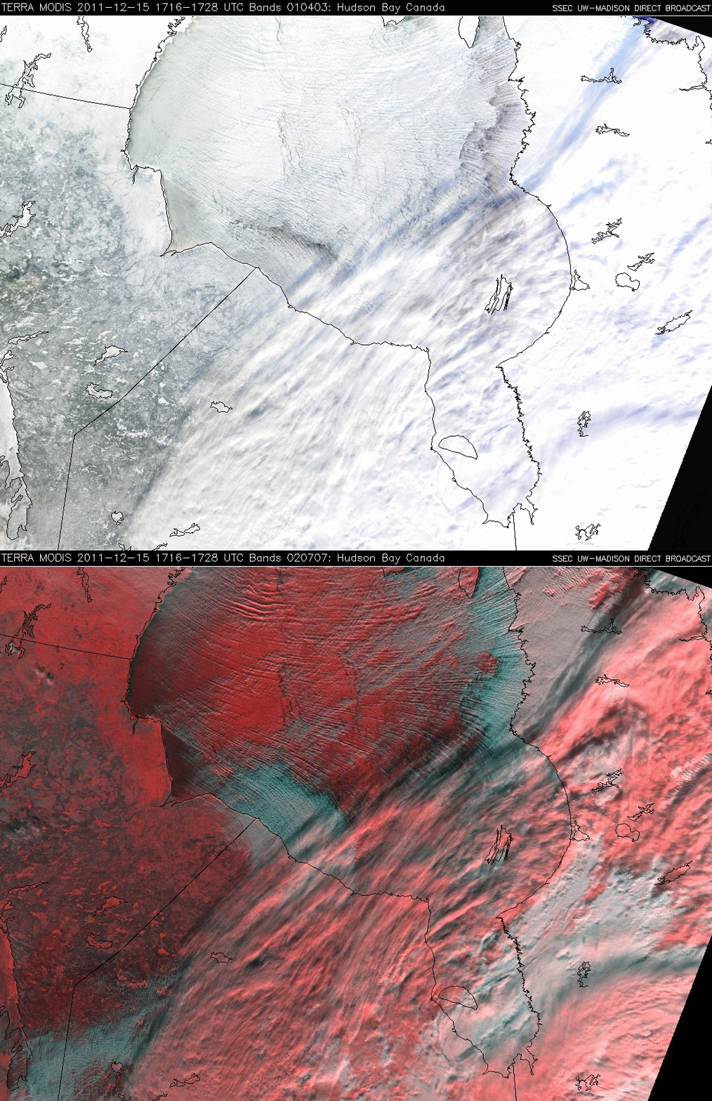
A comparison of a MODIS true color Red/Green/Blue (RGB) image with the corresponding MODIS false color RGB image of Hudson Bay, Canada on 15 December 2011 (above) revealed the following: (1) most of the northern and western portions of Hudson Bay were ice-covered... Read More

MODIS true color RGB image + MODIS false color RGB image

MODIS true color RGB image + MODIS false color RGB image

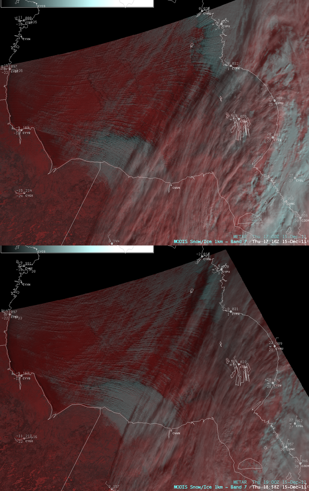
A comparison of a MODIS true color Red/Green/Blue (RGB) image with the corresponding MODIS false color RGB image of Hudson Bay, Canada on 15 December 2011 (above) revealed the following: (1) most of the northern and western portions of Hudson Bay were ice-covered (the ice appeared bright white on the true color image, and darker shades of red on the false color image) and (2) thee false color image made it easier to discriminate between the ice (darker red) and a diverging pattern of supercooled water cloud streets (white to cyan colored features) which were aligned in the direction of strong boundary layer winds in the wake of a cold frontal passage. The horizontal convective rolls that created these cloud streets may have also contained significant amounts of blowing snow.

AWIPS images of MODIS false color RGB images with overlays of METAR surface reports (below) showed that winds were gusting as high as 33 to 38 knots at stations along the western edge of Hudson Bay.

MODIS Red/Green/Blue (RGB) false color images

MODIS Red/Green/Blue (RGB) false color images

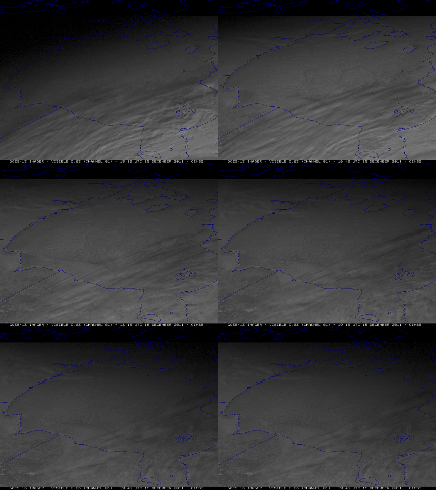
McIDAS images of GOES-13 0.63 µm visible channel data (below) showed that the strong winds were acting to move large portions of the ice, which according to the Canadian Ice Service was still fairly young “gray” (5-15 cm thick) to “gray-white” (15-30 cm thick) ice.

GOES-13 0.63 µm visible channel images

GOES-13 0.63 µm visible channel images

View only this post Read Less

Fog along the Gulf Coast

The National Weather Service forecast office in Mobile, Alabama mentoned their use of the MODIS fog/stratus product during the pre-dawn hours on 14 December 2011:AREA FORECAST DISCUSSION NATIONAL WEATHER SERVICE MOBILE AL 1140 PM CST TUE DEC 13 2011 .AVIATION UPDATE (14/06Z ISSUANCE)…LOW CIG AND VSBY CONDITIONS CONTINUE. GOES IMAGER 11-3.9... Read More

1-km resolution MODIS vs 4-km resolution GOES-13 fog/stratus product images

1-km resolution MODIS vs 4-km resolution GOES-13 fog/stratus product images

The National Weather Service forecast office in Mobile, Alabama mentoned their use of the MODIS fog/stratus product during the pre-dawn hours on 14 December 2011:

AREA FORECAST DISCUSSION
NATIONAL WEATHER SERVICE MOBILE AL
1140 PM CST TUE DEC 13 2011

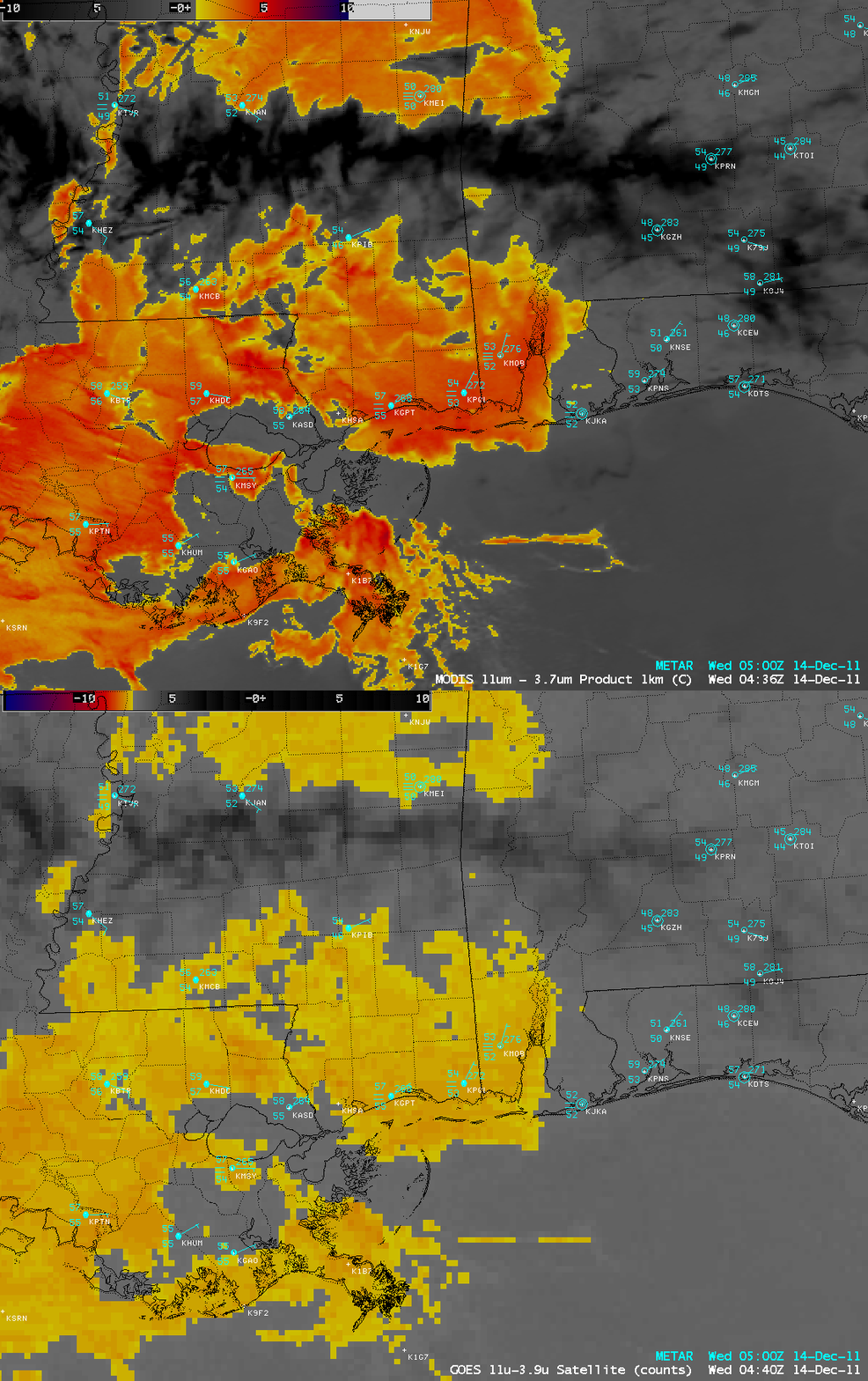
.AVIATION UPDATE (14/06Z ISSUANCE)…LOW CIG AND VSBY CONDITIONS CONTINUE. GOES IMAGER 11-3.9 AND MODIS POLAR ORBITER CONTINUE TO INDICATE A LOW STRATUS DECK WITH LOW VISIBILITY IN A LAYER WHOSE EDGE OVERLAYS A LINE FROM NEAR FOLEY TO BAY MINETTE AND ON UP TO CAMDEN. POINTS WEST OF SAID LINE ARE PRETTY WELL SOCKED IN AND PRETTY CLEAR ELSEWHERE. HAVE THEREFORE KEPT REDUCED PREVAILING GROUP TO A QUARTER MILE AND VV001 FOR BFM AND MOB.

A comparison of AWIPS images of the 1-km resolution MODIS vs the corresponding 4-km resolution GOES-13 fog/stratus product (above) demonstrated the advantage of using higher spatial resolution data to more accurately locate the eastern edge of the fog.

View only this post Read Less
Lake-effect snow cover downwind of Lake Erie

A 250-meter resolution MODIS true color Red/Green/Blue (RGB) image from the SSEC MODIS Today site (above) showed the areal coverage of lake-effect snow cover downwind of Lake Erie on 11 December 2011. Snow depths across this particular region were generally small, in the 1 to 4 inch range. ... Read More

MODIS true color Red/Green/Blue (RGB) image (displayed using Google Earth)

MODIS true color Red/Green/Blue (RGB) image (displayed using Google Earth)

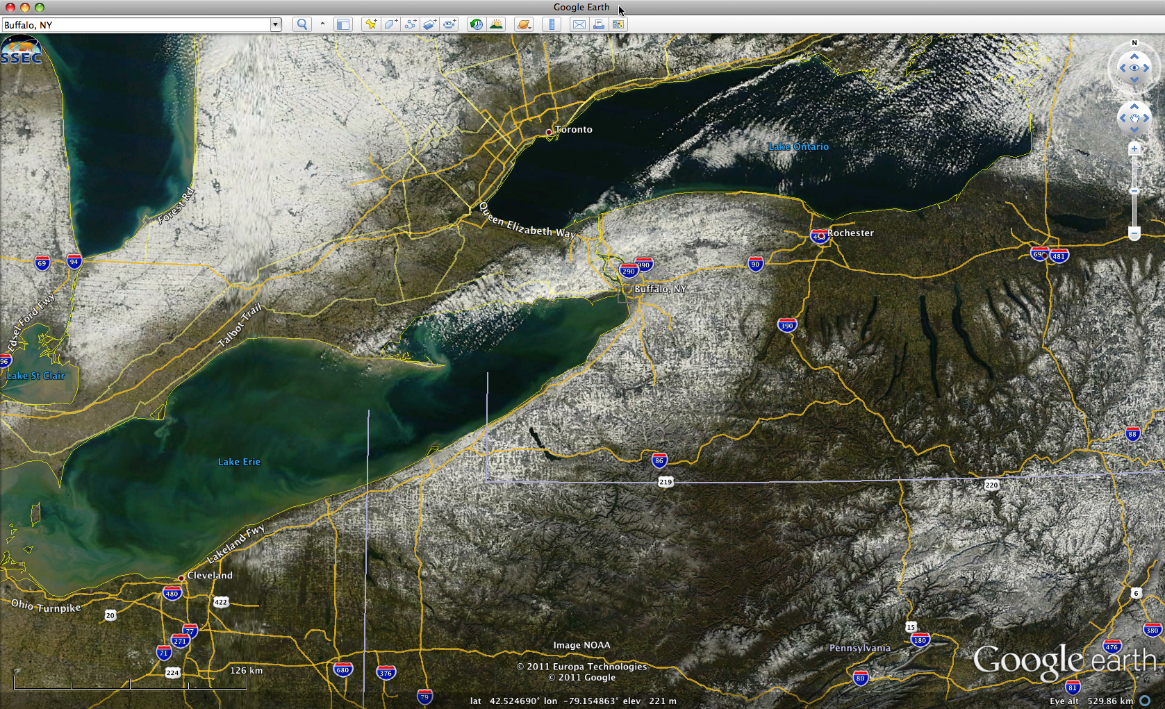
A 250-meter resolution MODIS true color Red/Green/Blue (RGB) image from the SSEC MODIS Today site (above) showed the areal coverage of lake-effect snow cover downwind of Lake Erie on 11 December 2011. Snow depths across this particular region were generally small, in the 1 to 4 inch range.

View only this post Read Less