This website works best with a newer web browser such as Chrome, Firefox, Safari or Microsoft Edge. Internet Explorer is not supported by this website.

GOES-14 SRSOR: severe thunderstorms over the central Plains

The GOES-14 satellite continued to be in Super Rapid Scan Operations for GOES-R (SRSOR) mode on 11 May 2014, capturing the development of thunderstorms along a dryline that stretched from the Texas Panhandle into far southwestern Kansas. As... Read More

GOES-14 0.63 µm visible channel images (click to play animation)

GOES-14 0.63 µm visible channel images (click to play animation)

The GOES-14 satellite continued to be in Super Rapid Scan Operations for GOES-R (SRSOR) mode on 11 May 2014, capturing the development of thunderstorms along a dryline that stretched from the Texas Panhandle into far southwestern Kansas. As a southward-moving cold front intersected this dryline, McIDAS images of 1-minute interval GOES-14 0.63 µm visible channel data (above; click image to play animation; also available as an MP4 movie file) showed that the narrow line of storms later developed into large discrete supercell thunderstorms over Kansas, with widespread reports of tornadoes, large hail, and damaging winds (SPC storm reports).

Farther to the northeast, other large supercell thunderstorms could be seen growing over eastern Nebraska along a warm frontal boundary — these storms exhibited numerous signatures of vigorous overshooting tops. Near the end of the animation, winds gusted to 82 mph at Omaha, Nebraska at 00:51 UTC.

GOES-13 sounder Convective Available Potential Energy (CAPE) derived product imagery (click to play animation)

GOES-13 sounder Convective Available Potential Energy (CAPE) derived product imagery (click to play animation)

AWIPS images of GOES-13 sounder Convective Available Potential Energy or CAPE (above; click image to play animation) and Total Precipitable Water or TPW (below; click image to play animation) with surface frontal analyses revealed the sharp gradient of both instability and moisture across the dryline — just to the east of the dryline, CAPE values exceeded 4000 J per kg (darker purple color enhancement), while TPW values were generally in the 30-40 mm or 1.2-1.6 inch range (shades of yellow). In addition, GOES-13 sounder Lifted Index values were in the -8 to -10º C range across parts of Kansas into southeastern Nebraska prior to convective initiation.

GOES-13 sounder Total Precipitable Water (TPW) derived product imagery (click to play animation)

GOES-13 sounder Total Precipitable Water (TPW) derived product imagery (click to play animation)

A 19:36 UTC Suomi NPP VIIRS 11.45 µm IR channel image (below) showed the early stages of convective development along the dryline in far southwestern Kansas; the coldest cloud-top IR brightness temperature value at that time was -80º C, just west of Dodge City, Kansas KDDC (corresponding GOES-14 visible image).

Suomi NPP VIIRS 11.45 µm IR channel image, with METAR surface reports

Suomi NPP VIIRS 11.45 µm IR channel image, with METAR surface reports

A comparison of POES AVHRRR 12.0 µm IR channel images (below) showed the explosive convective growth over Kansas and Nebraska in the 3-hour period between 19:56 UTC and 22:53 UTC.

POES AVHRR 12.0 µm IR channel images

POES AVHRR 12.0 µm IR channel images

Additional details on this event can be found on the RAMMB GOES-R Proving Ground Blog.

View only this post Read Less
Hail-Producing storm over the Texas Hill Country

A hail-producing storm (cick here for Storm reports from SPC) moved through Edwards, Real and Bandera counties of Texas after sunrise on May 9th. This storm gives a nice opportunity to compare ProbSevere and GOES-14 SRSO-R depictions of a severe storm. The 1400 UTC image, above, shows ProbSevere > 95%,... Read More

ProbSevere_09May2014_1400

AWIPS-2 display of a strong thunderstorm over Texas, including ProbSevere Readouts at 1400 UTC

A hail-producing storm (cick here for Storm reports from SPC) moved through Edwards, Real and Bandera counties of Texas after sunrise on May 9th. This storm gives a nice opportunity to compare ProbSevere and GOES-14 SRSO-R depictions of a severe storm. The 1400 UTC image, above, shows ProbSevere > 95%, with a MESH just over 1″. Within the next 10 minutes, MESH increased to 1.48″ at 1406 UTC (when ProbSevere was 96%), and to 1.92″ at 1408 UTC (see image below, when ProbSevere was 99%). A Severe Thunderstorm Warning was issued at 1408 UTC.

ProbSevere_09May2014_1408

AWIPS-2 display of a strong thunderstorm over Texas, including ProbSevere Readouts at 1408 UTC

The storm maintained its strength over the following half hour. Imagery from 1436 shows MESH values near 1.50″ and ProbSevere is at 99%. At 1442 UTC, the radar shapefile vanishes from the display, a result of processing errors, but it is back at 1444 UTC. Note that the Satellite Predictors have flipped at 1444 UTC from values derived at 1015 UTC to ‘Mature Storm‘ (this change has nothing to do with the missed processing at 1442 UTC). Recall that ProbSevere is designed to probabilistically determine whether or not a storm will produce severe weather in the next 60 minutes. ‘Mature Storm’ designations serve as a reminder that Probabilities have been elevated for a long period of time.

At 1458 UTC, below, near the end of the Severe Thunderstorm warning, the MESH value that is incorporated into the ProbSevere computation has decreased to 1.17″, and ProbSevere has dropped to “only” 97%. At 1502 UTC, however, MESH has started to increase again, to 1.21″ (and ProbSevere remains high); a second severe thunderstorm warning is issued at 1504 UTC when MESH is at 1.53″ (and ProbSevere is at 99% again). ProbSevere remains high through 1530 UTC.

ProbSevere_09May2014_1458

AWIPS-2 display of a strong thunderstorm over Texas, including ProbSevere Readouts at 1458 UTC

GOES-14 was in SRSO-R mode during this hail event, allowing an opportunity to see the storm evolution at very high temporal resolution. (The storm initially was right at the edge of the domain). The animation below shows cloud-tops warming around 1440 UTC, before cooling again, consistent with changing updraft speeds that can be inferred by changes in MESH. Cold temperatures occurred at 1501 UTC, 209.1 K. Temperatures were cooler than 210 K only at 1500 and 1501 UTC — that is, for two minutes — demonstrating the importance of 1-minute imagery in resolving without aliasing the coldest features at cirrus level. A second very cold event occurred between 1507 and 1509 UTC (brightness temperatures were cooler than 208 K); it was gone by 1511 UTC (when brightness temperatures were all warmer than 211 K). One-minute imagery is necessary to resolve these very rapid changes at cirrus level.

ProbSevere_09May2014_1458

GOES-14 Visible (0.62 µm) (top) and GOES-14 IR (10.7 µm) (bottom) from 1401 UTC through 1530 UTC on 9 May. Edwards, Real and Bandera Counties are highlighted

The plot below shows the coldest IR Brightness Temperature observed in the GOES-14 10.7 µm channel over the hail-producing storm. Tic-marks along the x-axis are at 5-minute intervals, and there are large differences that occur with time-scales shorter than 5 minutes. This is consistent with the findings of Cintineo et al. in the September 2013 issue of Journal of Applied Meteorology and Climatology (link).

BT_CloudTop_SRSO

Minimum cloud-top IR Brightness Temperature over hail-producing storm, from 1411-1530 UTC. Tic marks on x-axis every 5 minutes.

During the following hours, 1-minute interval GOES-14 0.63 µm visible channel images (below; click image to play animation; also available as an MP4 movie file) showed other areas of convection which produced damaging winds across parts of southeastern Texas.

GOES-14 0.63 µm visible channel images (click to play animation)

GOES-14 0.63 µm visible channel images (click to play animation)

View only this post Read Less
GOES-14 Super Rapid Scan Operations for GOES-R (SRSOR) 1-minute interval imagery

Another period of activating GOES-14 for Super Rapid Scan Operations for GOES-R (SRSOR) began on 08 May 2014. One area of severe thunderstorms began to develop over the South Dakota/Nebraska/Minnesota/Iowa region, as see on McIDAS images of 1-minute interval GOES-14 0.63 µm visible channel data (above; click... Read More

GOES-14 0.63 µm visible channel images (click to play animation)

GOES-14 0.63 µm visible channel images (click to play animation)

Another period of activating GOES-14 for Super Rapid Scan Operations for GOES-R (SRSOR) began on 08 May 2014. One area of severe thunderstorms began to develop over the South Dakota/Nebraska/Minnesota/Iowa region, as see on McIDAS images of 1-minute interval GOES-14 0.63 µm visible channel data (above; click image to play animation; also available as an MP4 file).

An AWIPS image of GOES-13 0.63 µm visible channel data at 15:15 UTC with overlays of METAR surface observations and fronts/pressure analysis (below) showed that a well-defined warm frontal boundary was in place across the region at 15 UTC, which helped to act as a focus for convective development as it moved northward during the morning and afternoon hours. The Storm Prediction Center had outlined a Moderate Risk for severe thunderstorms over this area, and later issued a Tornado Watch at 17:50 UTC. The first report of hail from these storms was at 17:03 UTC over far western Minnesota (SPC storm reports).

GOES-13 0.63 µm visible channel image with METAR surface reports and surface front and pressure analyses

GOES-13 0.63 µm visible channel image with METAR surface reports and surface front and pressure analyses

SRSOR mode provides the opportunity to compare satellite scanning strategies. The animation below (also available as an MP4 movie file) shows

GOES-13 0.63 um visible channel images: Standard 15-minute interval (left), RSO (center), and SRSOR (right) [click image to play animation]

GOES-13 0.63 um visible channel images: Standard 15-minute interval (left), RSO (center), and SRSOR (right) [click image to play animation]

Another comparison of SRSOR vs RSO vs Standard image scan modes is shown below, focusing on convection farther south over the Kansas / Oklahoma / Texas region (click image to play very large animated GIF file; click here for the same animation on YouTube; an MP4 version is also available here).

GOES14_1655_8May2014_Center_OKC

GOES-13 0.63 µm visible channel imagery in SRSO mode (left), in RSO mode (center) and in Standard mode (right) (click to animate very large file)

View only this post Read Less
Tropical Invest 90E in the eastern Pacific Ocean

AWIPS images of the MIMIC Total Precipitable Water product (above; click image to play animation) showed the well-defined cyclonic circulation associated with Tropical Invest 90E in the Eastern Pacific Ocean during the 06 May – 07 May 2014 period.Overlays of the tropical surface analysis... Read More

MIMIC Total Precipitable Water product (click to play animation)

MIMIC Total Precipitable Water product (click to play animation)

AWIPS images of the MIMIC Total Precipitable Water product (above; click image to play animation) showed the well-defined cyclonic circulation associated with Tropical Invest 90E in the Eastern Pacific Ocean during the 06 May – 07 May 2014 period.

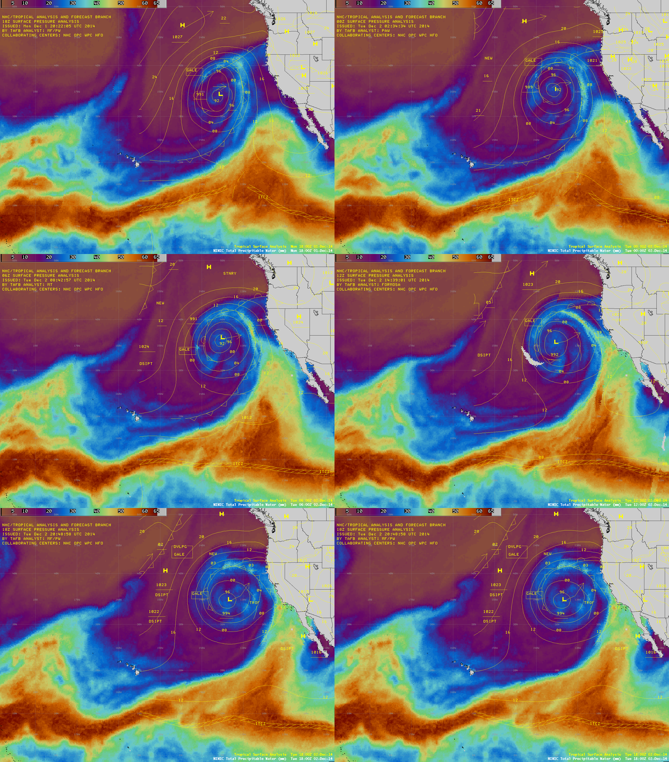
Overlays of the tropical surface analysis at 6-hour intervals (below) indicted that the area of low pressure formed in the region of a fracture in the InterTropical Convergence Zone (ITCZ) / Monsoon Trough off the southwest coast of Mexico.

MIMIC TPW product with tropical surface analyses

MIMIC TPW product with tropical surface analyses

An overpass of a polar-orbiting Metop satellite provided ASCAT surface scatterometer winds at 16:41 UTC (below). The strongest winds were generally in the 20-30 knot range.

MIMIC TPW product with Metop ASCAT winds

MIMIC TPW product with Metop ASCAT winds

Near the end of the day, the lowering sun angle helped to highlight shadowing on GOES-15 0.63 µm visible channel images (below; click to play animation) associated with overshooting tops in the eastern quadrant of the low; the Tropical Overshooting Tops product helped to unambiguously highlight the location of these overshooting top features.

GOES-15 0.63 µm visible channel images, with Tropical Overshooting Tops product (click to play animation

GOES-15 0.63 µm visible channel images, with Tropical Overshooting Tops product (click to play animation)

View only this post Read Less