This website works best with a newer web browser such as Chrome, Firefox, Safari or Microsoft Edge. Internet Explorer is not supported by this website.

GOES-13: First Day of Post-Launch NOAA Science Test

07 December 2006 was the first day of the GOES-13 post-launch NOAA science test. The satellite was placed into Rapid Scan Operations mode, to monitor the development of lake-effect snow (LES) bands across the Great... Read More

GOES-13 visible channel image

07 December 2006 was the first day of the GOES-13 post-launch NOAA science test. The satellite was placed into Rapid Scan Operations mode, to monitor the development of lake-effect snow (LES) bands across the Great Lakes region. GOES-13 visible channel imagery (above) depicted well-defined, persistent LES bands that had developed over Lake Huron (Exeter, Ontario radar) and Georgian Bay (King City, Ontario radar) — a Java animation of GOES-13 visible images shows these LES bands moving inland over southeastern Ontario, where they produced 18-35 inches of snow (including 12 inches in a 3 hour period) in what was one of the worst snowstorms in nearly 3 decades for London, Ontario.

.
GOES-13 visible images centered farther to the south (below) revealed a particularly long LES band that was moving off Lake Michigan and drifting southeastward across southwestern lower Michigan, northeastern Indiana, and southwestern Ohio (Java animation). This LES band deposited as much as 11 inches of new snow in southwestern Michigan, with 5-6 inches falling farther downstream in parts of northeastern Indiana. A GOES-13 visible image from the following morning shows several narrow streaks of snow cover (oriented northwest to southeast across Indiana and Ohio), many of which were left by the LES bands seen on 07 December.
GOES-13 visible channel image

View only this post Read Less

More big fires in southern California

Aqua MODIS true color imagery (above) revealed a long smoke plume originating from a large wildfire that was burning northwest of Los Angeles on 03 December 2006 (500-meter resolution image). Strong northeasterly Santa Ana winds (gusting... Read More

MODIS true color image

Aqua MODIS true color imagery (above) revealed a long smoke plume originating from a large wildfire that was burning northwest of Los Angeles on 03 December 2006 (500-meter resolution image). Strong northeasterly Santa Ana winds (gusting to 33 mph at nearby Thousand Oaks, CA) were helping to create an environment favorable for rapid wildfire growth. Farther to the north, haze was evident over parts of the Sacramento and San Joaquin Valleys, where unhealthy particle pollution levels were present — the Santa Ana winds appeared to be ventilating some of this haze from the interior valleys, blowing it westward over the San Francisco region and out across the adjacent Pacific Ocean.

View only this post Read Less

TROWALs in a storm

Occluded strong systems will occasionally display features that suggest the presence of a TROWAL, or a TROugh of Warm air ALoft. The midwestern snowstorm of 1 December 2006 was no exception. The pressure analysis below over the Infrared (channel 4 from GOES 12) data, which... Read More

Occluded strong systems will occasionally display features that suggest the presence of a TROWAL, or a TROugh of Warm air ALoft. The midwestern snowstorm of 1 December 2006 was no exception. The pressure analysis below over the Infrared (channel 4 from GOES 12) data, which data has been stretched, shows an occluded system in east-central Illinois. Other features of note include the obvious snow band in Missouri, Kansas and Oklahoma that is speckled by the heat of unfrozen lakes.

Stretched IR from 12z 1 December 06

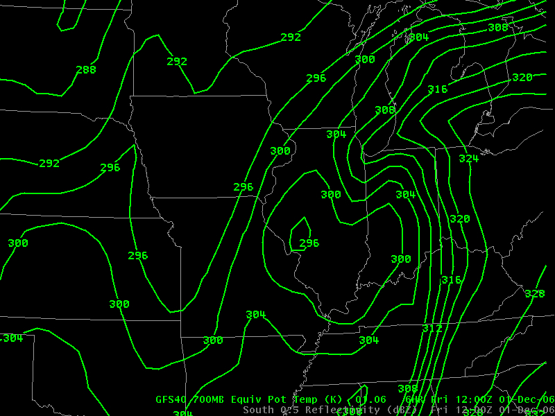
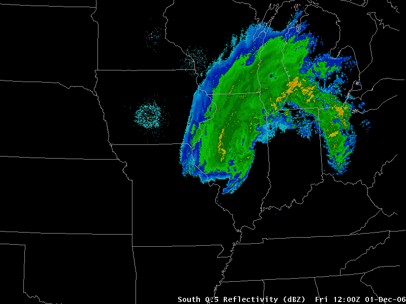
A signature of a TROWAL is a thin tongue of warm air north of the occluded system. Conceptual models of storms, such as those by Carlson (warm and cold conveyor belts) suggest warm air off to the east of the storm in the warm conveyor belt. The GFS 700-mb Theta-E analysis below, for example, shows a narrow tongue of warm air stretching along the southern Lake Michigan shoreline. This corresponds well with the position of strong echo returns from radar.
700-mb ThetaE from GFS

Radar from 12z

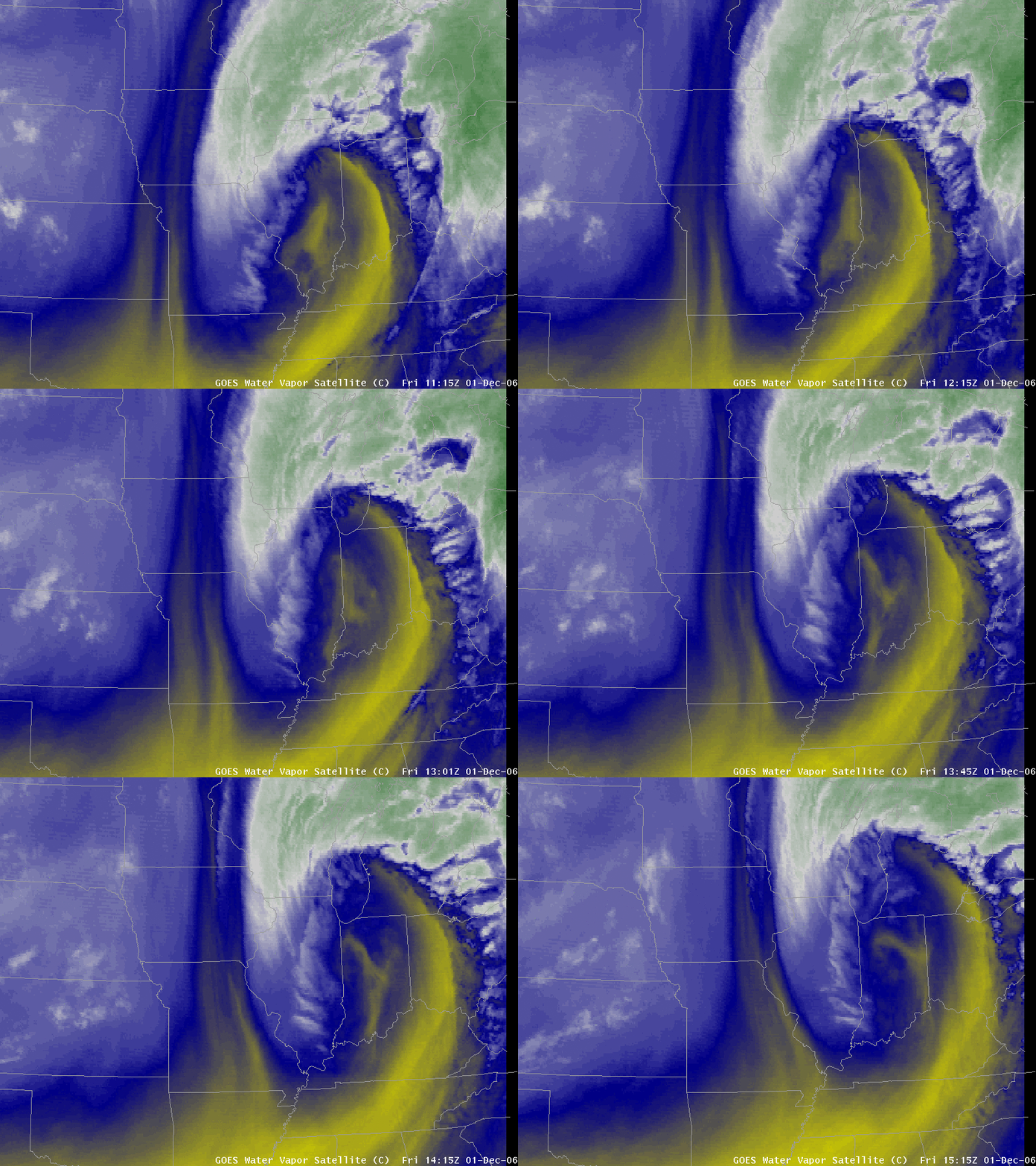
The inference to draw from these images is that warm and moist air drawn north in the TROWAL air stream helps to sustain precipitation very near the dry slot. Consider the water vapor loop below, that shows redevelopment of precipitation over southern Lake Michigan, precipitation that subsequently moves over the western shoreline. Where is the moisture source for this developing precipitation? Strong forcing of the coupled jets will produce vigorous ascent, but unless an airstream, such as a TROWAL airstream, supplies moisture, the ascent will not yield heavy precipitation. During this storm, heavy snowfalls over eastern Wisconsin suggest the presence of a TROWAL airstream that is confirmed in thermodynamic fields (above) between the surface and 500 mb.
Animated Gif of WV imagery

View only this post Read Less

Heavy snow from Texas to Michigan

An impressive winter storm (which featured a TROWAL airstream) brought snow, sleet, and freezing rain to much of the central US during the 30 November to 01 December 2006... Read More

MODIS true color image

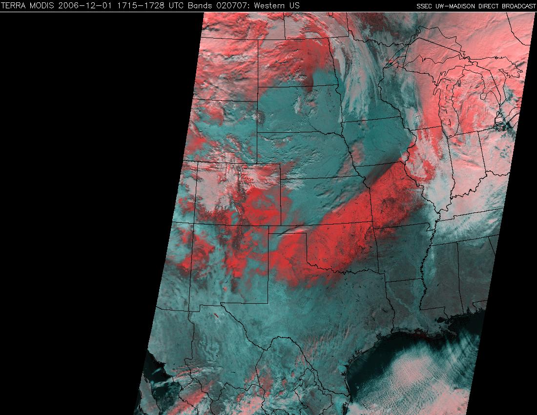
An impressive winter storm (which featured a TROWAL airstream) brought snow, sleet, and freezing rain to much of the central US during the 30 November to 01 December 2006 time frame — maximum snowfall totals included 8 inches in Texas, 15 inches in Oklahoma, 16 inches in Kansas, 18 inches in Missouri, 18 inches in Illinois, 17 inches in Wisconsin, and 17 inches in Michigan. The extensive swath of fresh snow cover was quite evident on the 01 December MODIS true color image (above; snow cover and clouds appear white) and false color image (below; snow cover and ice crystal clouds appear as shades of red, while water droplet clouds appear white). Note that if you fade between the MODIS true color and false color images (Java fader applet), you can see that there is also an area of ice-covered ground across parts of northern Missouri and southcentral Iowa (just north of the main snow band) — those areas received a significant glazing of ice due to freezing rain 2 days earlier (as discussed in the 30 November blog posting).

Also of interest is the rapid melting along the periphery of the southwestern portion of the snow cover (especially across Texas and Oklahoma) during the day on 01 December (QuickTime animation of GOES-12 visible images).


MODIS false color image

View only this post Read Less