This website works best with a newer web browser such as Chrome, Firefox, Safari or Microsoft Edge. Internet Explorer is not supported by this website.

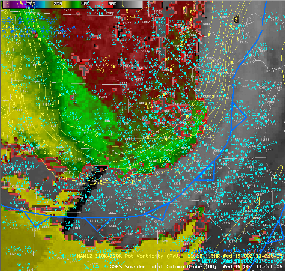
GOES Sounder Total Column Ozone

A deep cold core upper-level low rapidly intensified over the northcentral US and southcentral Canada on 11 October — cold air in the wake of a strong southward-moving cold frontal boundary allowed many sites across the Upper Midwest and the western Great... Read More

AWIPS GOES sounder total column ozone
A deep cold core upper-level low rapidly intensified over the northcentral US and southcentral Canada on 11 October — cold air in the wake of a strong southward-moving cold frontal boundary allowed many sites across the Upper Midwest and the western Great Lakes region to see their first snow of the season (13-22 inches fell in northern Wisconsin and the UP of Michigan, snow pellets were seen here in Madison area, and Detroit, Michigan experienced their earliest measurable snowfall on record); this system later gave Buffalo, New York it’s snowiest October day ever (14.0 inches on 13 October). The AWIPS image of GOES sounder total column ozone (above) shows a lobe of elevated ozone (350 Dobson Units or higher, green to red enhancement) which was moving southward across the Dakotas, Minnesota, and Iowa (QuickTime animation). This upper-tropospheric ozone feature corresponded with the lowering tropopause heights (denoted by the potential vorticity contours greater than ~2.0 PVU within the 310-320 K isentropic layer) associated with the core of the deepening 500 hPa vortex. Ozone and potential vorticity are both tracers of stratospheric air — high values in the upper troposphere are seen when tropopause heights drop (due to tropopause folding around jet streaks or upper-level frontogenesis, or deepening of upper-level cyclones).

View only this post Read Less

Warm and cold conveyor belts

A deep cyclone was intensifying over the Mid-Atlantic states on 06 October; this storm was eventually responsible for heavy rains and high winds that caused flooding over parts of Virginia. The AWIPS GOES water vapor channel image at 11:45 UTC (above) showed... Read More

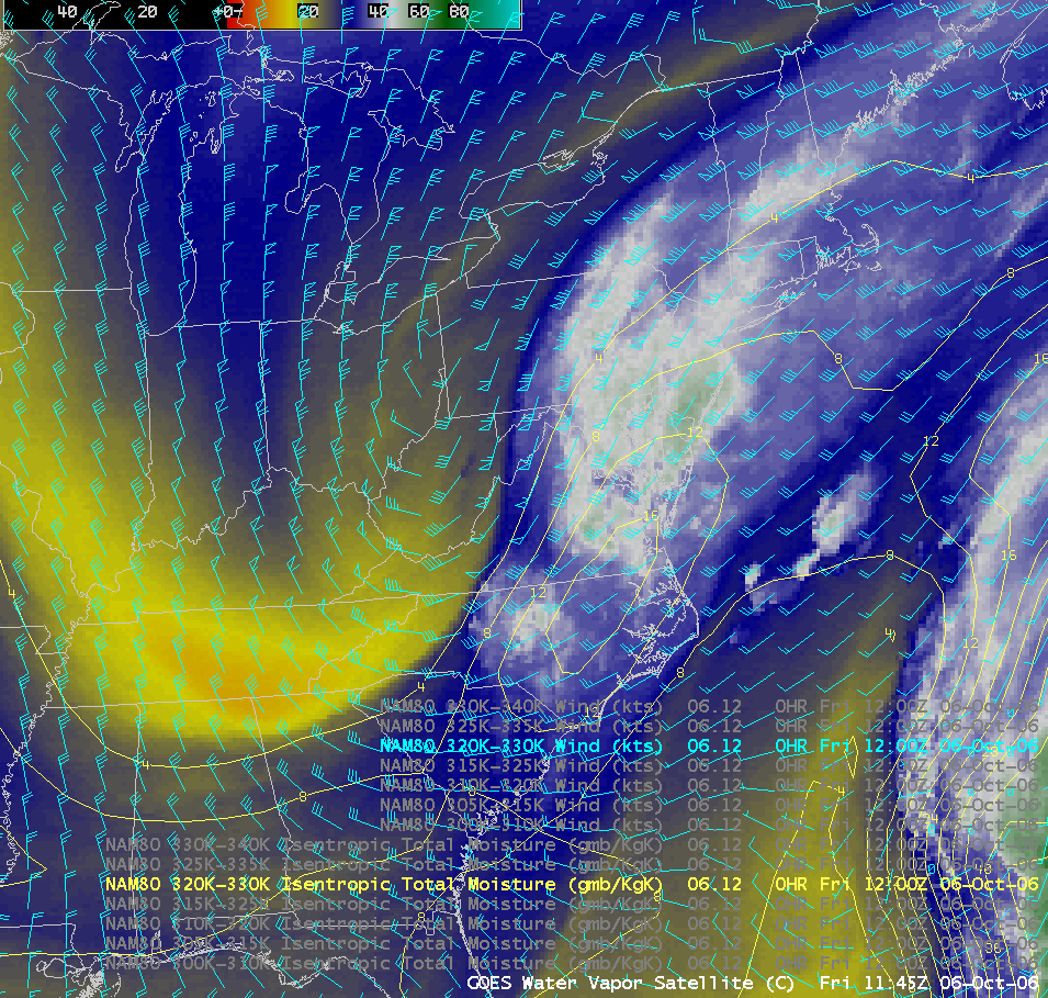
AWIPS GOES water vapor image
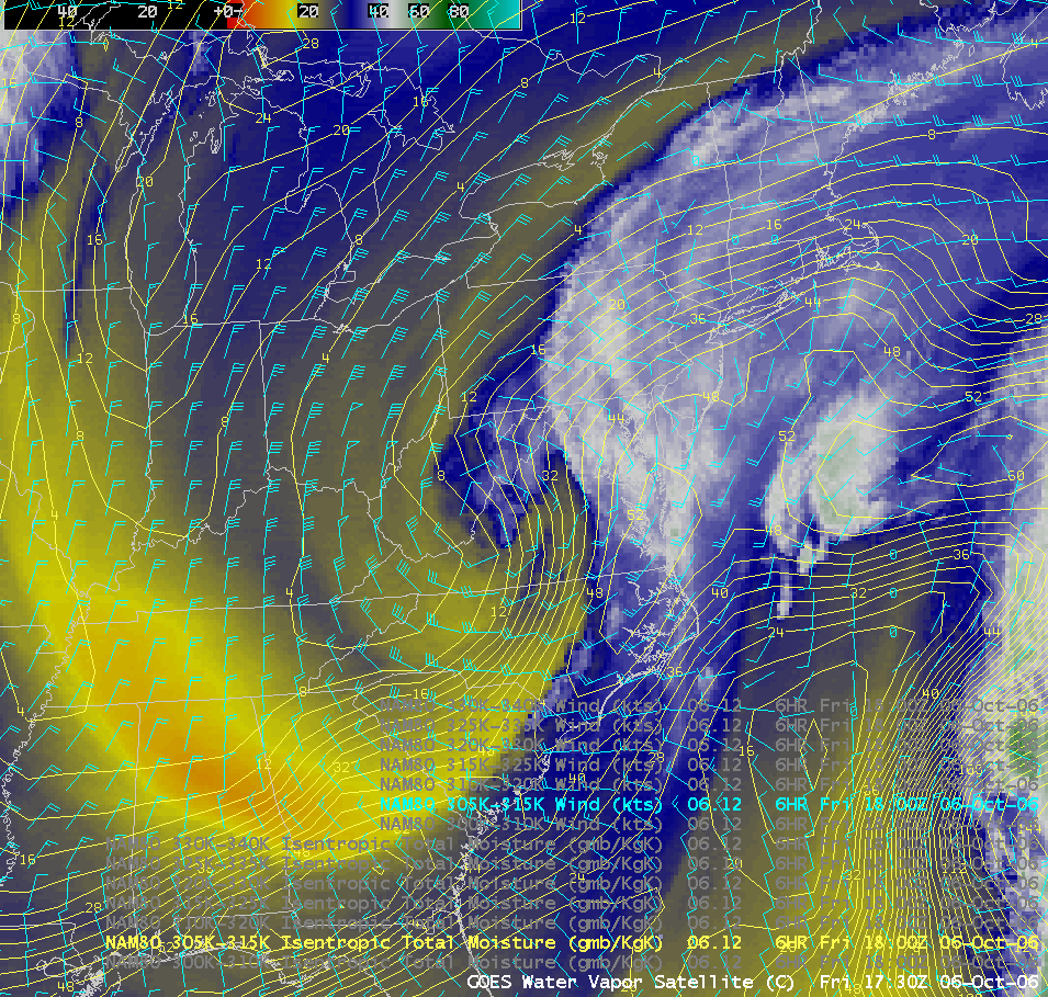
A deep cyclone was intensifying over the Mid-Atlantic states on 06 October; this storm was eventually responsible for heavy rains and high winds that caused flooding over parts of Virginia. The AWIPS GOES water vapor channel image at 11:45 UTC (above) showed the warm conveyor belt as a plume of moist southwesterly flow within the 320-330 K isentropic layer. The water vapor image 6 hours later (at 17:30 UTC, below) reveals the cold conveyor belt emerging at lower altitudes (within the 305-315 K isentropic layer) and moving westward as the cyclone deepened (11 MB QuickTime animation).

AWIPS GOES water vapor image

View only this post Read Less

Gulf Stream, and Autumn color

The AWIPS MODIS Sea Surface Temperature product (above) reveals the dramatic water temperature contrast associated with the Gulf Stream off the East Coast of the US on 04 October. Sea surface temperatures were as warm as 81 F (red enhancement) along the axis of the Gulf Stream off the... Read More

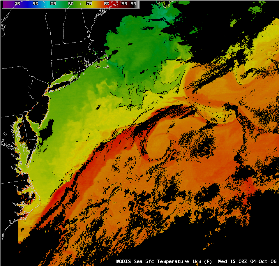
AWIPS MODIS sea surface temperature
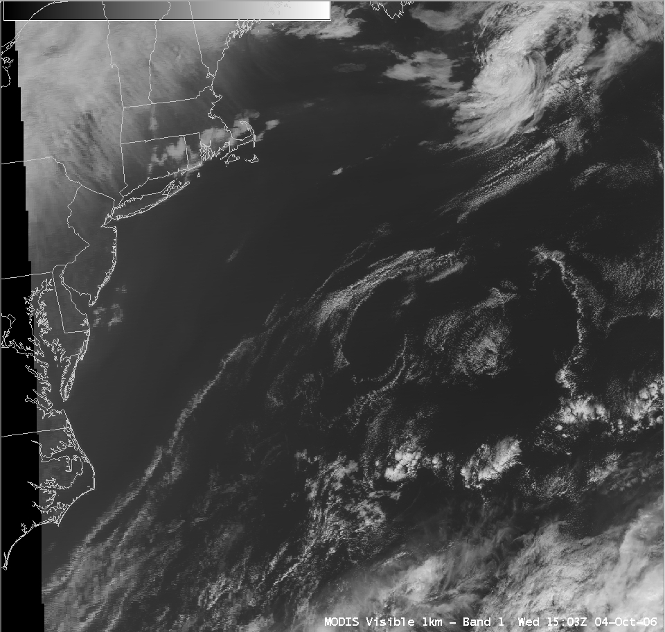
The AWIPS MODIS Sea Surface Temperature product (above) reveals the dramatic water temperature contrast associated with the Gulf Stream off the East Coast of the US on 04 October. Sea surface temperatures were as warm as 81 F (red enhancement) along the axis of the Gulf Stream off the coast of North Carolina, and as cold as 53 F (cyan enhancement) off the coast of New England and Nova Scotia. Mesoscale variability in the water temperatures are evident which are not well depicted by the Real-time Global Sea Surface Temperature (RTG_SST) analysis. The corresponding AWIPS MODIS visible image (below) shows a typical example of the narrow cumulus cloud lines (or “rope clouds”) that often form along the sharpest temperature gradient of the Gulf Stream axis (as well as along the periphery of some of the ocean circulation eddies) — the contrast in water temperatures acts as a differential heating boundary to focus marine boundary layer convergence and initiate subsequent formation of the narrow cumulus cloud features. A QuickTime animation of GOES-12 visible imagery shows that these rope clouds remained quasi-stationary during the course of the day.
AWIPS MODIS visible image

Closer to home, the Aqua MODIS true color image shows that the Autumn tree colors are reaching their peak across much of northern Wisconsin and the UP of Michigan.

View only this post Read Less

Final day of GOES-10 SRSO

Beginning on 23 August, the GOES-10 satellite was placed into continuous Super Rapid Scan Operations (SRSO) mode, providing images at 1-minute intervals over a limited region of the US. 02 October was the final day of GOES-10 SRSO, and some of the interesting... Read More

Beginning on 23 August, the GOES-10 satellite was placed into continuous Super Rapid Scan Operations (SRSO) mode, providing images at 1-minute intervals over a limited region of the US. 02 October was the final day of GOES-10 SRSO, and some of the interesting features that were apparent on the visible channel imagery included:

GOES-10 visible animation
(1) a distinct “aircraft dissipation trail” (10 MB QuickTime animation, above) running north-south through a patch of cloudiness located over northeastern Kansas. GOES-12 10.7 micrometer cloud top temperatures in that particular cloud feature were in the -25 to -35 C range, and GOES Sounder Cloud Top Heights were generally 25-30 Kft, suggestive of cirrus clouds that were likely composed of ice particles; the MODIS Cloud Phase product a few hours later did in fact indicate mostly ice phase in that area of cloudiness as it moved eastward across the Kansas/Missouri border region. Small particles in the aircraft exhaust may have acted as effective ice condensation nuclei, causing the cloud ice particles to grow and begin falling out of the cloud (creating the aircraft dissipation trail signature);
GOES-10 visible animation
(2) morning dissipation of valley fog (12 MB QuickTime animation, above) over parts of the central Appalachian Mountains region (map overlay);

GOES-10 visible animation
(3) development of severe convection over northern Illinois and southern Wisconsin (36 MB QuickTime animation, above) which produced numerous reports of heavy rain, hail, and damaging winds (SPC storm reports).

View only this post Read Less