Hurricanes
A hurricane is a tropical cyclone that occurs in the Atlantic Ocean.
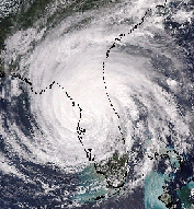
Tropical cyclones are large low pressure systems without any "front" attached. They stand out on satellite images due to their circular cloud patterns and, in stronger storms, a nearly clear eye at the center. The clarity and size of the eye on satellite images helps meteorologists estimate a cyclone's strength.
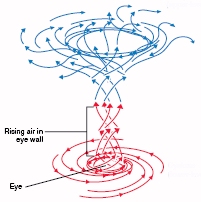
Immediately surrounding the eye is a narrow, circular, rotating region of intense thunderstorms called the eye wall. Winds in the eye wall thrust up as much as a million tons of air every second. Hurricanes are essentially large weather engines fueled by the latent heat of water generated when ocean water enters the atmosphere as vapor. The energy required for this evaporation process comes from the Sun, and this energy is lying in wait -latent- ready to be released again when the vapor is condensed into liquid. |

Hurricane Jeanne, 2004
Click to enlarge
|
Ingredients for a Hurricane
1) Warm ocean waters about 80�F ( 27�C) or warmer.
2) Lack of vertical wind sheer that might slow or detour rising air drafts.
3) Some sort of pre-existing weather disturbance that convection can converge around.
| Hurricane Formation
As air rises, the water vapor cools and condenses into clouds. Condensation releases heat. This heat warms the atmosphere making the air even lighter so it can rise faster and higher into the atmosphere. New air moves in near the surface creating the strong wind associated with hurricanes. The replacement air is always mild and moist due to the warm ocean waters, helping convection continue.
Air spirals in toward the center of a hurricane in a counterclockwise pattern near the ocean (clockwise in the southern hemisphere), and out the top in the opposite direction. In the very center of the storm, air sinks, forming an "eye" that is mostly cloud-free.
Once the eye of the storm moves over land they tend to weaken rapidly, not because of friction, but because the storm lacks the moisture and heat that the ocean provided to produce convection and thunderstorms near the storm center. |
 Click to enlarge
 |
Hurricanes and Climate Change
Since hurricanes are fueled by warm ocean waters and depend upon the availability of water vapor
in the atmosphere, many scientists predict increasingly stronger hurricanes due to the gradual warming of Earths oceans and atmosphere. Others expect the total number of hurricanes to increase each year. To date, 2005 set the all-time record for both the overall total and the number of major (strong) hurricanes.
Thunderstorms
Thunderstorms, like hurricanes, require great amounts of energy from the atmosphere.
|
| Visible Image

Click to enlarge
|
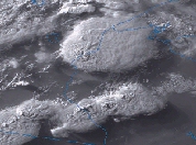
This energy is released when saturated air rises rapidly in the sky. For this reason, thunderstorms are associated with tall cumulonimbus clouds.
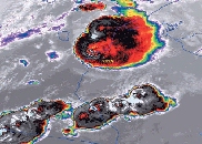
The air in cumulonimbus clouds rises so rapidly that their tops frequently poke through the tropopause. These overshooting tops
can be seen on visible satellite images by the shadow they cast on the lower "anvil" cloud top or by their cold temperatures on IR satellite images.
|
IR Image

Click to enlarge
|
Tornadoes
A tornado is a violently rotating column of air in contact with the ground.
Since tornadoes form from the bottom of a thunderstorm, a satellite
can’t “see” tornadoes. However, pre-tornadic conditions such as overshooting tops on visible and IR images or an unstable atmosphere depicted by satellite sounder profiles are routinely used by meteorologist to warn the public. Once a tornado is detected, satellites are used to track the storm.
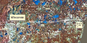
Satellite images frequently depict tornado damage tracks, as illustrated by the following high resolution LandSat image. |
| Tornado path across northern Wisconsin
 Click to enlarge
 |
Blizzards
A blizzard is an organized winter storm packing winds over 35 mph, blinding wind-driven snow, severe drifting, and dangerous wind chill.
Blizzards are frequently called “Deceptive Killers” because most deaths that result are indirectly related to the storm, people die in traffic accidents on icy roads or from hypothermia due to prolonged exposure to cold.
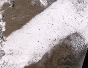
Satellites are excellent winter storm trackers as well as providing the
best evidence of where the heaviest snow fell after a storm passes. |
 Click to enlarge
 |

