Test your ability to interpret satellte imagery to make short term weather forecasts with the following activities:
 1. Intrepreting satellite imagery
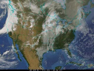
Click on the image to the right to begin the activity. You will be expected to identify the Highs, Lows and Fronts on March 25th by interpretaing the satellite image.
 2. Taking image intrepretation one step further
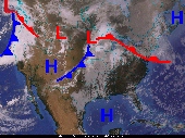
Click on the image to the right to continue to test your interpretation skills at a slightly more advanced level.
 3. Making a Weather Forecast
Using satellite imagery and a temperature map from March 25th, your job is to forecast the high temperature, the amount of cloud cover, the wind direction and whether it will be raining or snowing at select locations on the following day, March 26th. Please print out this forecast sheet and then click on the image to the right and make your forecast.