 A new
interactive contouring excerice has been
added where you draw the contours using the mouse. Results are provided.
A new
interactive contouring excerice has been
added where you draw the contours using the mouse. Results are provided.
Meteorologists analyze many sources of data in forecasting the weather. Satellite images, radar, computer models, and maps of temperature, dewpoint temperature, pressure, and winds are most useful. Often the maps of data are contoured for clarity and to emphasize significant weather features. Analyzing contoured data from the Oakfield tornado helps show some important weather features associated with the development of thunderstorms and severe weather. Uncontoured maps are provided for those who wish to develop or practice their contouring skills. For those who would like to learn how to contour data an exercise is provided. This exercise would be excellent for students and teachers.
A new
interactive contouring excerice has been
added where you draw the contours using the mouse. Results are provided.
Much can be learned from analyzing maps of surface data. This data shows weather conditions at specific observing stations. There are many stations all over the United States that report weather conditions every hour. Many of these stations are located in larger cities such as San Francisco, CA or Chicago, IL, but some are in very small isolated towns like Ely, Nevada. The data is gathered by the National Oceanic and Atmospheric Administration (NOAA) and its subsidiary the National Weather Service where it is compiled and made available to many information services such as television and radio stations. Differences in the weather between stations are of primary interest. For example, if two stations less than 100 miles apart have different surface temperatures of 15° Fahrenheit, it is likely a significant weather feature is causing the disparity. The contoured maps aid in understanding and predicting what types of weather will be affecting certain regions. In addition, computer models are now extremely useful in forecasting. There are many long tedious calculations that need to be made to predict how the atmosphere will behave. Extremely powerful computers are used to solve millions of mathematical calculations based on physical properties of the atmosphere. It would take humans days to do these calculations. Computers can do these in seconds with much greater accuracy. This type of weather forecasting is usually referred to as Numerical Weather Prediction (NWP). Meteorologists rely heavily on the computer generated forecasts in their analysis.
There are many types of maps that meteorologists use. Pressure, temperature, dewpoint temperature, and wind are some of the most important and easily understood maps. Analyzing these atmospheric variables will be the primary focus. Surface pressure is a significant feature of interest since low pressures indicate rising vertical motions which usually leads to clouds and precipitation, while high pressures signify downward vertical motion giving fair weather. Temperatures are important for indicating the type of air mass. Winds are also important in showing where and how fast the air is propagating. The dewpoint temperature represents how much water vapor is in the air. The dewpoint temperature is the temperature the air would need to be cooled to become saturated. Saturated air has a relative humidity of 100%. Saturation is required for the formation of clouds and precipitation.
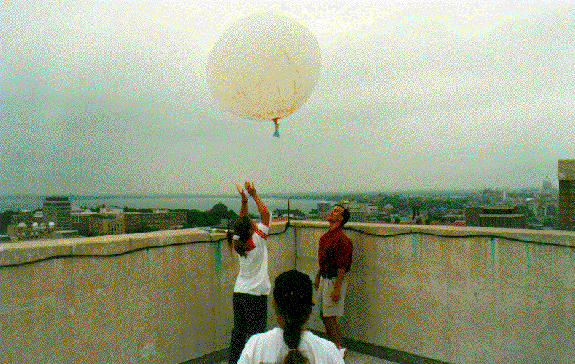
Television and radio reports typically focus on surface weather forecasts, such as a cold rainy day. What is not explained are the conditions above the surface, which are of vital importance in weather forecasting. For this reason it is vital to analyze weather conditions at the Earth's surface and the conditions aloft. How is this done? Weather balloons are simultaneously launched from certain National Weather Service stations all over the United States. The balloons rise up high into the atmosphere, taking measurements throughout. The information is then relayed back and plotted on maps. Not every National Weather Service station launches these balloons, often called radiosondes, because they are very expensive. The stations that do launch these balloons are spaced in a way to effectively monitor conditions across the country at the cheapest cost possible. The likelyhood of weather balloons being launched from Oakfield is very small. Instead there are several stations that can be used to help identify the conditions over Oakfield. Green Bay, WI, Davenport,IA, and Minneapolis/St. Paul are all stations close to Oakfield.
The radiosondes are launched twice a day. Once at 1200 GMT and once at 0000 GMT (00Z and 12Z is more typically used). This universal time system is used so there is no confusion among scientists who communicate across the world. For example if a meteorologist in Madison, WI was talking to one in Eugene, OR saying it was 2 PM when the snow began. The meteorologist in Eugene might be confused in thinking is it 2 PM Pacific Standard Time or 2 PM Central Standard Time. To end this confusion Greenwich Mean Time (GMT) is used. This is the time in Greenwich, England based on a 24 hour clock, similar to the way military time is kept. 00 GMT is midnight in Greenwich, England. Midnight in Greenwich, England corresponds to 6 PM in Madison, WI and 4 PM in Eugene, OR. As for the two meteorologist discussing what time the snow began to fall in Madison it is simple and clear to say it fell at 20Z (20 GMT). When it's Daylight Savings Time, 00Z corresponds to 7 PM Wisconsin time.
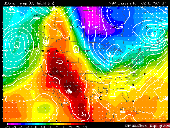
The information from these weather balloons are typically plotted on maps of 850mb, 500mb, and 250mb. These maps are often referred to as the upper-air observations. The average atmospheric pressure at sea level is 1013mb. As one goes up the pressure decreases because there is less atmosphere pushing down. The 850mb map describes the conditions of the atmosphere where the pressure is 850 millibars.
The map above is a 850mb analysis. This is one example of how contouring is useful. This map has two different variables contoured. The white lines are geopotential heights and the colored regions represent temperatures. The little arrows indicate the magnitude and direction of air flow.
Why are all these levels of the atmosphere important? The 850mb map is very important in knowing how much moisture is available for precipitation, especially in the spring and summer. When there is high dewpoint temperatures at the surface and at 850mb the atmosphere is "juicy", meaning there is plenty of moisture to be possibly converted to precipitation, which would likely lead to the formation of thunderstorms. The 850mb level usually corresponds to around 5000ft above sea level. Thus if the atmosphere is moist from the surface to 850mb and there was a mechanism for that moist air to be lifted up in the atmosphere to a level where cloud formation occurs, a thunderstorm may ensue. In addition, winds at this level are important in showing what types of air masses are influencing the weather. At 850mb the effects of friction from the Earth's surface is weaker, giving a better analysis of the state of the atmosphere. Stronger winds are often found at this height. These winds are important in the movement of moisture out of the Gulf of Mexico. The 850mb level is also important in winter for predicting precipitation types like freezing rain. If the temperatures above the surface in winter are above freezing, while temperatures at the surface are below freezing, it is possible to have freezing rain.
The 500mb level represents conditions in the middle of the atmosphere. Low pressure features are also very easily identified in this region. They are often termed troughs in the upper levels. Troughs represent dips in the contours that are pushed toward the equator. High pressure features are often termed ridges in the upper levels and are easily acknowledged by isobars that bow out toward the North Pole away from the normal east/west flow. The 500mb level is usually where the middle of a cyclone is located. Cold air at this level, ahead of the trough, but above the warm moist air creates a conditionally unstable atmosphere.
The 250mb level is used to study jet streams. Jet streams and jet streaks, are the main directing component of atmospheric systems, and are the result of north/south temperature gradients. Contouring isotachs at this level is more valuable than streamlining, as this well help locate special features like the jet streak. In addition, this level is also important in analyzing if surface air will rise. Divergence at 250mb typically requires the replenishment of air from below, instigating and maintaining storm development. There is a direct correlation with the strength of the winds and the strength of the storms.
The synoptic situation which produced the severe weather in Oakfield, WI can clearly be understood by analyzing the surface and upper-air data. The tornado struck at 7:15 PM midwest time on August 18th or 0015Z, 12:15 AM in Greenwich, England on August 19th. Weather forecasters strive to predict these storms in advance allowing plenty of time for the public to be warned. To do this data from 12Z (7 am central daylight time) is examined. It contains the most recent upper-air data and it allows a forecast to be made well in advance of the weather event. Contouring the data will highlight special features of atmospheric interest.
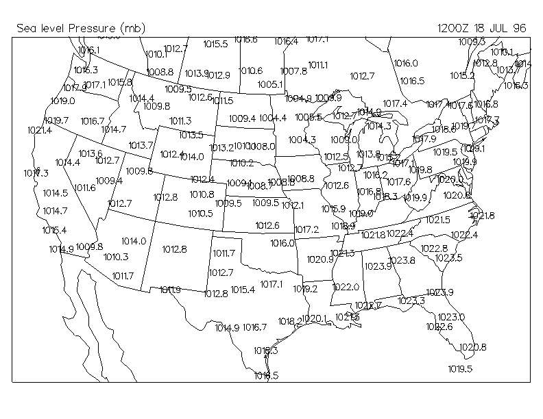
For every map analyzed, the first is the uncontoured version for those doing the contouring exercise. The second map is the completely contoured version for reference and analysis. The contoured version provided is not the only correct interpretation of the data. Though your contour analysis may look different, it may be correct, as there are many possible variations. Starting with the surface maps and then working up in height.
12Z Surface Pressure Uncontoured : 12Z Surface Pressure The main feature is the low pressure system centered over Minnesota. The low pressure system represents converging surface air. Laws of physics require that air flow from from higher pressures toward lower ones. The air is then moving toward the low pressure center due to the strong pressure gradient. One would think that the air would cross the isobars perpendicular. This doesn't happen as the coriolis effect turns the air to the right in the northern hemisphere, thus the flow of air is parallel to the isobars in a counter-clockwise rotation. However, friction at the Earth's surface then turns this air to the left by about 20°. The net result is air converging at the low pressure center. When it converges the only direction for it to go is up. As it rises it cools, moisture condenses into clouds, and if the clouds get cold and deep enough precipitation will result. Thus, lower surface pressures imply greater vertical ascent and deeper colder clouds
There is also a strong high pressure system centered over Georgia. As the air flows from higher pressures toward lower ones there is a need to replace what is moving away from the high. The air must come from above resulting in divergence at the surface. Air from aloft is much drier than air near the surface. Just as air cools as it rises it also warms as it sinks. The air aloft then warms and gives pleasant weather to the southeastern US. Flow around the high pressure system is clockwise. Looking at the isobars and knowing the flow between them is nearly parallel, it is easy to see that much of the air is flowing over the warm moist waters of the Gulf of Mexico resulting in high amounts of evaporation into the air mass. The high is advecting moist air over the Southern Plains States and into the Great Lakes region. The dewpoints and streamlines of wind should prove this.
One final feature to note is the tight gradient of isobars stretching from Oklahoma and Kansas up into Ohio and Indiana. Large pressure gradients represent strong winds. The wind barbs should show increased wind speeds in this region compared to the rest of the US.
Primary Interests: Low pressure feature in Midwest could be a major source for vertical motion. High pressure over Southeast advecting warm and moist air into a region where there is potential for vertical motion and the development of storms.
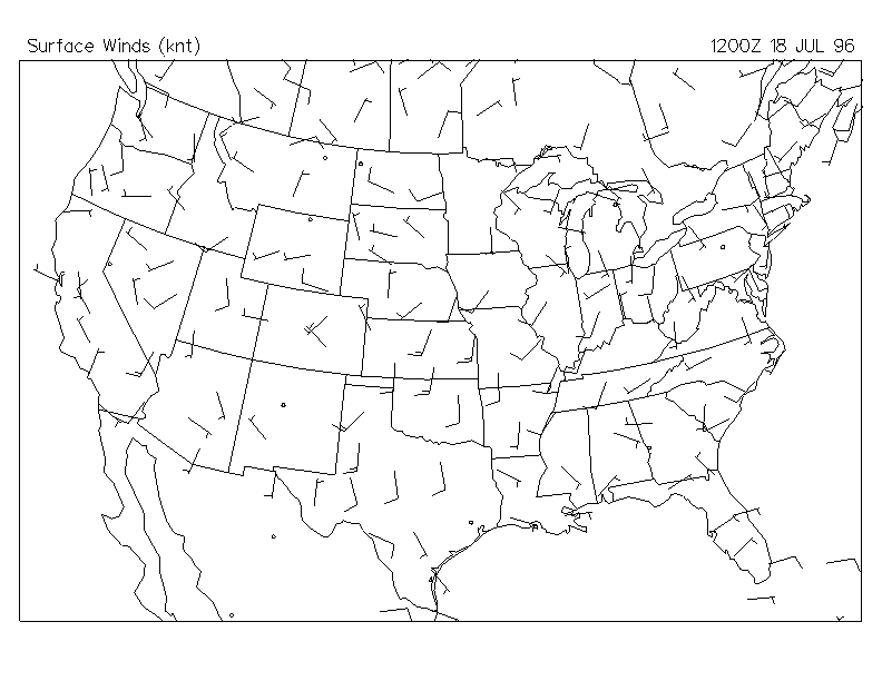
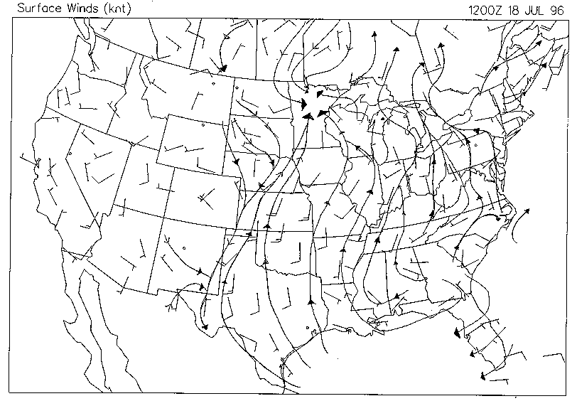
12Z Surface Winds Unstreamlined : 12Z Surface Winds Streamlined
Streamlines prove that the air is being advected off the warm waters of the Gulf of Mexico. The streamlines originate out of the Gulf and can be followed all the way into Wisconsin and Minnesota. All the regions within these streamlines can expect to be humid, indicated by high dew point temperatures. The air to the west of Minnesota through eastern Kansas originates from northern latitudes. This air can be expected to be much cooler and drier. These streamlines collide at nearly right angles with those coming from the south in Nebraska, Kansas, and Minnesota. This strong change in wind direction indicates the likely location of the cold front. A cold front line could be put here but should be crossed referenced with the contours of temperature. Convergence of air accompanies these colliding streamlines, producing an eruption of storms in this elongated area.
Strong winds were possible as predicted from the tight pressure gradient in the pressure analysis. The strongest winds show up as expected over the Southern Plains and into the Ohio River Valley. Winds over mountainous areas are very difficult to decipher as air flow is influenced by differential heating/cooling and frictional effects of the mountain peaks.
Primary Interests: Warm air from the Gulf of Mexico being directed into the Midwest. Cooler air from Canada colliding with the warm air, a clashing of air masses. Stronger winds with the tighter pressure gradient.

