
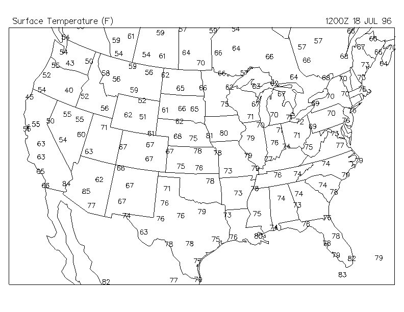
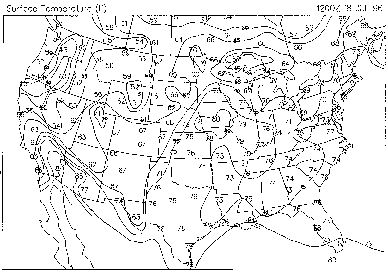
12Z Surface Temperatures Uncontoured : 12Z Surface Temperatures The most striking acknowledgement is the temperatures over Iowa and eastern Nebraska being 80°F. Most of the Ohio River Valley and Southern Plains states are very warm with temperatures well into the 70's. Being it is 7:00 AM in the Midwest and Plains, temperatures in the upper 70's and 80's likely represents very muggy conditions. Temperatures usually cool significantly overnight. Moist air holds the heat in the atmosphere, preventing it from escaping into space and cooling the surface. The moist air acts as an insulating blanket. The warm temperatures hint at the high humidity. There is a tight gradient of temperatures that run through Kansas, Nebraska, and Minnesota. This is the location of the cold front. The cold front also lined up exactly where the streamlines converged. There is a gradient of temperatures that curve over and through Wisconsin indicating the warm front. In addition, the temperatures over the northern portion of the Great Lakes are much cooler than surrounding areas.
Primary Interests: Warm temperatures over Midwest and Plains with likely associated high dewpoints. Gradient of temperatures provide likely locations of cold and warm fronts.
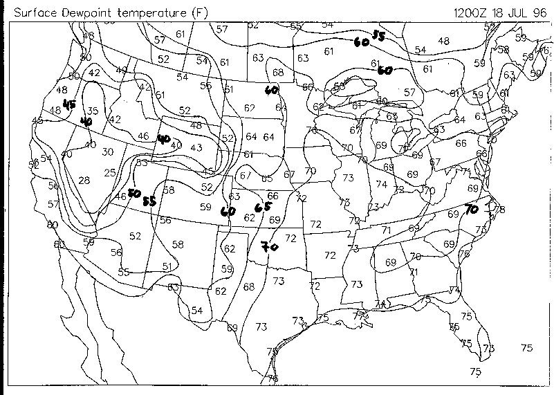
Surface Dewpoint Uncontoured : Surface Dewpoint Dewpoint temperatures of greater than 70° F extends over much of the southern US and into Wisconsin as predicted. These temperatures are extremely high, making conditions very humid and uncomfortable. The advection of the high dewpoints into this area was related to the high pressure system over the southeast. The dewpoint temperatures are dependent on the air moving over the warm surface waters of the Gulf of Mexico. The warmer the surface water in the Gulf, the more water will be evaporated into the air. The amount of moisture being evaporated also depends on how fast the wind is moving and the distance the wind blows over the water, also known as the fetch. An important factor to consider is crops. July is in the peak of the growing season, especially for vegetables like corn. As air is advected over the dense corn and vegetable fields of the Plains and Midwest, dewpoints can actually increase by several degrees as evapotranspiration takes place. The plants transpire, as large amounts of water are required to maintain plant growth and development. A large portion of this moisture is evaporated into the air mass and increases the moisture content. High dewpoint temperatures provide the necessary energy and moisture for strong storms.
The air coming from the north, as expected has a cooler dewpoint temperature. A sharp change in dewpoint temperatures can also differentiate air masses allowing for fronts to be distinguished. The gradient is more notable in the Plains but is not as significant in the Midwest. This is the likely location for the dryline to set up. The dryline is often the site for storm development.
Primary Interests: High dewpoint temperatures in the Plains and Midwest can provide the necessary energy and moisture for powerful storms. Developing dryline over Kansas, Nebraska, and South Dakota.
Summary of Surface Maps: All the maps from the surface at 12Z have been analyzed. There is plenty of moisture available for thunderstorm development. The low pressure system is the mechanism which could allow this moisture to converge at the surface for possible thunderstorm initiation. Analysis of upper-air data is needed to determine where the low will track, how deep the layer of moisture is, and the stability of the atmosphere.
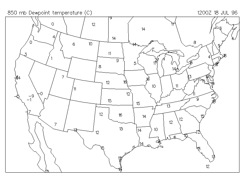
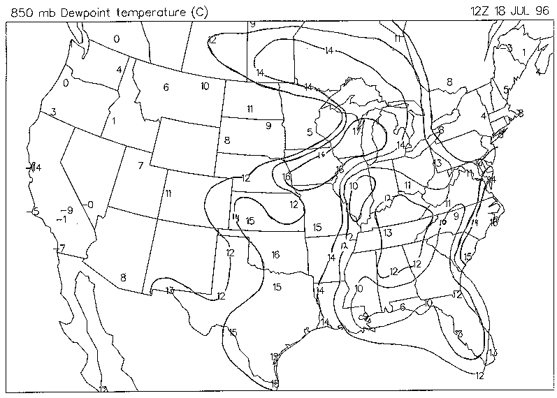
850mb Dewpoint Uncontoured : 850mb Dewpoint Temperature
There is very humid air stretching from Texas up into the Wisconsin. The temperatures are in degrees Celsius (C) but can easily be converted into Fahrenheit (F) by the following equation: F=1.8*°C+32. In Green Bay the dewpoint temperature is close to 63° F. A very high temperature for 850mb. 850mb is approximately 5000ft in elevation. The moist layer is thus proven to be quite deep in the lower layers of the atmosphere, giving the potential to provide plenty of "juice" and energy for storms. The dewpoint temperatures significantly drop in just a few hundred miles to the west as indicated by the 5° Celsius (41°F) reading from Minneapolis/St. Paul. There are higher dewpoint temperatures just to the west of Minneapolis, making the analysis difficult. It should be noted, due to the large gaps in data between radiosonde sites creative contouring is sometimes required to provide what the conditions are like in between stations.
Primary Interests: Deep layer of moisture in Iowa and Wisconsin. Large gradient stretching into Minnesota and South Dakota.
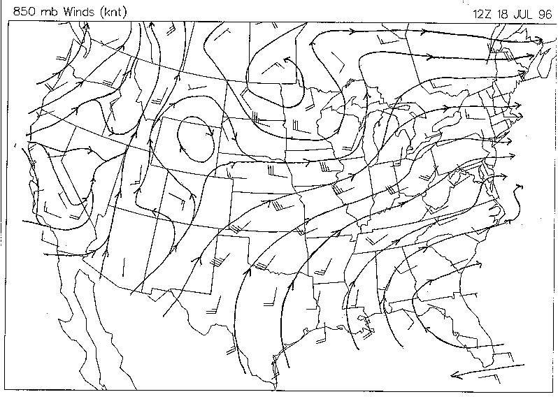
850mb Winds Unstreamlined : 850mb Winds
The streamlined winds continue to show that much of the air is originating out of the Gulf of Mexico. The winds have significantly increased from those at the surface. In addition the winds are more parallel with the geopotential height contours. The reason for the turning of the air from being parallel with the contours was friction. At 850mb there is less friction slowing the air, allowing it to move faster. The 850mb level is continuously watched because southerly flow is a major energy provider to thunderstorms, as it continuously replenishes moisture rich Gulf air. The lower dewpoint temperatures in Minnesota can clearly be reasoned, as the air is coming directly from Canada. This cooler and drier air is strengthening the surface front.
Primary Interests: Strong southerly 850mb winds replenish moisture rich air into the Midwest. Streamlines show air from Canada colliding with moist surface air in the Dakotas and Minnesota, leading to a strengthened surface front and providing an unstable atmosphere.
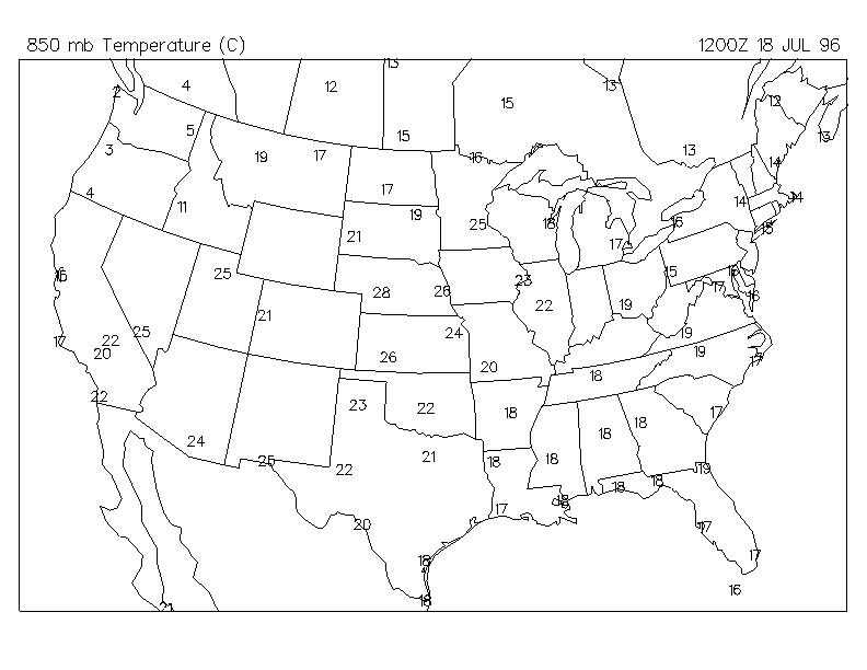
850mb Temperature Uncontoured : 850mb Temperature
The most striking features are the extremely warm air over Nebraska and Iowa along with the sharp gradient of temperatures draped across the upper Midwest. After converting the temperatures to Fahrenheit it becomes apparent that the air is actually warmer aloft than at the surface. How can this be possible? This type of condition is known as an inversion, as temperatures increase with height. The inversion only occupies a small layer in the atmosphere. Hot air out of the deserts of the southwestern US ride up and over the less warm and moist air from the Gulf of Mexico producing the inversion. The two layers do not mix very well. The lower layer is often called the planetary boundary layer. The surface then cools to temperatures below that of the air in the planetary boundary layer. The inversion is extremely important in building up the moisture and temperature levels near the surface. The higher these levels at low-layers compared to upper-layers, the greater the potential for strong storms.
This inversion is visible at 850mb over Nebraska. There is likely an inversion over Illinois and Wisconsin as well but is not seen at this level as it can be higher up in the atmosphere. The inversion is important for "capping" low level air. This cap prevents air from rising freely in the atmosphere. As surface air heats it becomes less dense and may rise. As it rises it cools from expansion. If it finds it's temperature to be below that of the inversion it will be unable to rise and form storms. The atmosphere is then considered stable. Thunderstorms are not likely to develop during this time of the day without getting some help to break the inversion. During the day, the surface can sometimes heat to a temperature that is greater than the inversion and can then be convective allowing thunderstorms to develop. It is for this reason thunderstorms usually develop in the afternoon. The cap can be broken in the morning hours if there is some mechanism to help lift it through the inversion. Strong low pressure centers often will do this allowing morning thunderstorms.
Primary Interests: Strong inversion preventing the development of thunderstorms. Inversion is allowing moisture and heat to build. Once inversion or "cap" is broken explosive development of thunderstorms is likely to result.
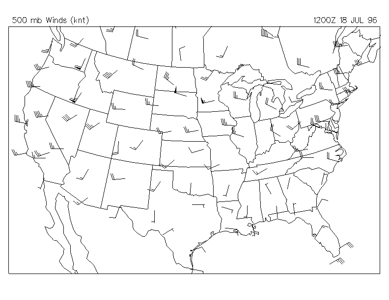
500mb Uncontoured Isotachs : 500mb Isotachs
The 500 mb layer is important for looking at the middle levels of the atmosphere, corresponding to approximately 18,000 feet in elevation. The isotachs hint at which direction the storm will be moving. The wind barbs are diverging throughout Wisconsin and Minnesota, suggesting surface air is being drawn upward. The diverging streamlines should be thought of as the major mechanism for providing the surface low pressure feature. The winds are strongest over Minnesota and Wisconsin, indicative of where the jet stream is located. These strong winds are the result of the large differences in air masses to the north and south. The strong jet is the result of potential energy between the air masses being converted into the kinetic energy of the winds.
Primary Interests: Strong mid-level winds and divergence appear to maintain and possibly deepen surface low pressure system. Wind barbs indicate system will track over upper portions of Wisconsin and Michigan.
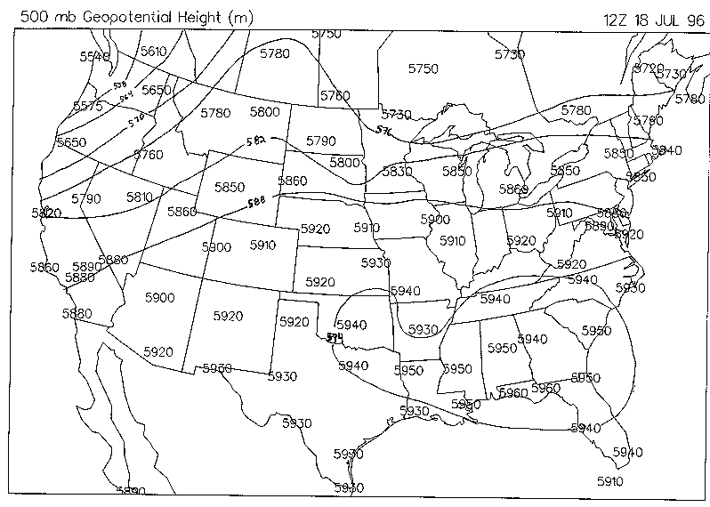
500mb Uncontoured Geopotential Heights : 500mb Geopotential Heights
As mentioned earlier pressures are determined by the analogous geopotential heights in the upper levels. There is a height minimum of 5,730 meters centered over Minnesota indicating the location of the upper-level trough. The height maximum, ridge, is located over the southeast. Air flow in between the contours are parallel as the effects of surface friction are negligible at this altitude. This can be proven by overlying the wind barbs on to the contours.
Primary Interests: Trough centered over Minnesota with main flow over the Midwest.
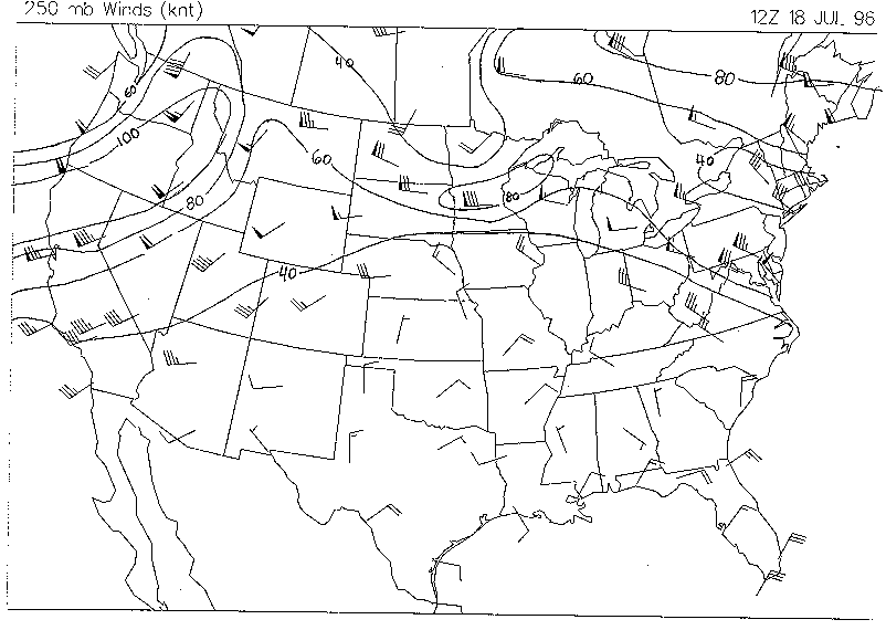
250mb Uncontoured Isotachs : 250mb Winds
The most important feature to the meteorologist at the 250mb pressure level is the winds. The winds are important as its the typical location of the jet stream. The jet stream is located around 10,500 meters or 35,000 feet. It is quite clear that the strongest winds run from west to east across Montana, North and South Dakota, Minnesota, and into Wisconsin. For example, planes going to the west would not want to fly at this altitude or in the westward direction, as the winds would oppose the plane, slowing it down and wasting fuel. The jet stream is important for maintaining surface cyclones There is strong diffluence aloft, providing favorable conditions for bringing surface air upward.
Primary Interests: A strong jet stream and divergence is providing the necessary dynamics for bringing moist surface air upward. The early morning inversion is strong enough to overcome this, preventing storm development. With afternoon heating, the inversion will weaken, but upper-air dynamics will be maintained, giving rise to explosive thunderstorm development.
What happen's if the surface parcel never becomes convective as the inversion inhibits the parcel from rising? This happens quite often. This is why looking at the 250mb level is so important. Diverging streamlines act like a straw in a milkshake by sucking surface parcels upward. If the divergence is strong enough in the upper-levels to allow surface parcels to break the inversion, convection and subsequently thunderstorms will result.
A convective parcel is allowed to rise as long as it stays warmer than the surrounding environment. It can do this because of its lapse rate. The surrounding environmental air aloft is cooler than the surface because the atmosphere heats from the surface up. Unsaturated air, less than 100% humidity, cools at a rate of about 10° Celsius per kilometer. This is often referred to as the dry lapse rate. Surface air heats at different rates due to the varying types of topography such as lakes or an asphalt road. Dark surfaces, such as asphalt, absorbs the sun's energy more effectively than lighter surfaces. The air over asphalt will be much warmer than the surrounding air and can be than thought of as an enclosed air parcel. Because it is much warmer than the surrounding air, it will want to rise. As the parcel rises it expands and cools at 10°C. If it cools to a point where it becomes saturated it will behave differently by by cooling at a lapse rate of about 6°C per kilometer. If this parcel ever becomes cooler than the surrounding air at the same altitude it will be more dense and forced to sink. This parcel is then not convective because it can't spontaneously rise on it's own. The quicker the parcel becomes saturated the better chance it has at being convective, as it will only cool at 6°C compared to the environments 10°C rate. As mentioned earlier, the environment doesn't always cool at 10°C, as many times it actually increases, an inversion. The inversion is usually a very shallow layer in the lower atmosphere. If the surface parcel is able to break through the inversion it will likely become convective. Likewise, air can cool much faster than 10°C, especially in advance of low pressure system. Often times this advancing cold air aloft is much denser than the warm surface air. The colder air will want to sink and the warmer and more moist surface air is displaced upward, usually resulting in convection.
Simply stated, for a thunderstorm to develop the air must be convective and want to rise. It can do so because the parcel of air is not cooling as it rises as fast as that of the atmosphere. Winds in the upper-levels, around 250mb, are often required to help pull up the surface parcels.
From analyzing all the wind barb maps throughout the atmosphere it becomes apparent that the winds increase and change direction with height. This is a very important factor in producing severe weather. There are many different types of thunderstorms that develop such as squall lines, air mass thunderstorms, and supercells. Atmospheric scientists/meteorologists can often times predict what type thunderstorms will develop by analyzing how the winds change with height.