The purpose of this site is to analyze a severe weather event using many general scientific applications used by meteorologists. It can also be viewed as a hands on exercise to forecasting the weather, as it focuses on the events and data that spawned a devastating tornado that struck Oakfield, Wisconsin on July 18th, 1996. Analyzing satellite images, Doppler radar, and contoured surface/upper-air data will give a thorough understanding of what conditions led to the severe thunderstorms which roared across the upper-Midwest (clicking on any weather related terms will provide a meteorological dictionary).
This web page can provide the following activities for students, teachers, and weather enthusiasts.
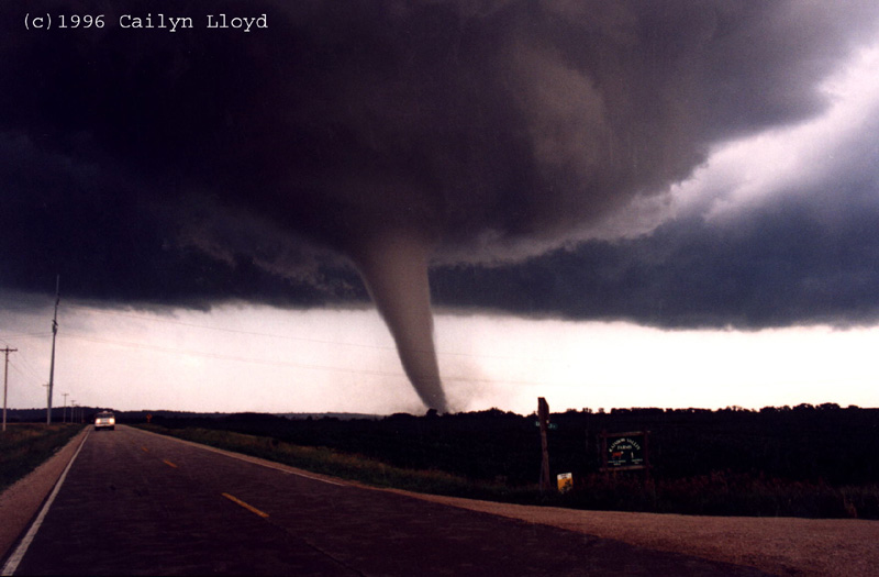
On July 18, 1996 the town of Oakfield, Wisconsin was all but destroyed by a powerful tornado. In addition to the tornado, strong thunderstorms brought heavy rains, lightning, and gusty winds to the region. All of these elements resulted from the passage of a cold front. The violent tornado developed in Fond du Lac County and moved southeastward across Wisconsin taking direct aim at Oakfield. At 7:15 PM the large tornado struck the 1,000 person town, injuring 17 people. Damage estimates totaled over $40 million as 47 of 320 homes were destroyed. In addition, 56 homes as well as numerous businesses and churches sustained heavy damage. A "state of emergency" was declared by Governor Tommy Thompson allowing National Guard soldiers to be called in to aid victims and clear debris.
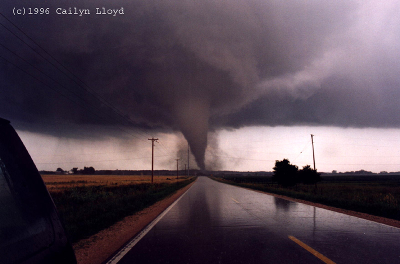
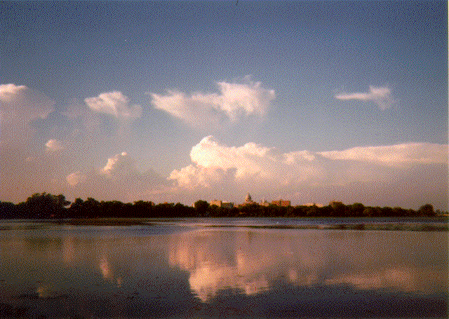
The tornado was powerful enough to level the Friday Canning Company, while picking up millions of empty cans and leaving them sprawled over a 50 mile distance. Besides structural damage to buildings the tornado was quite costly to farmers; Crops, livestock, and farm equipment were also destroyed. The original National Weather Service report from Milwaukee/Sullivan categorized the tornado to be a F3 to F4, winds of 158-260 mph, although it was later upgraded to an F5, winds greater than 261 mph, the most severe tornado possible. F5 tornadoes are very rare, only occurring, on average, every other year in the United States. The F5 status was issued based on the inspection of the damage in the Oakfield area. National Weather Service (NWS) tornadic storm warnings of the Oakfield tornado can be viewed NWS Oakfield Tornado Report. When a tornado watch is issued, conditions are favorable for the formation of tornadoes. A warning is issued when an actual tornado has been reported. The tornado stayed on the ground for over 20 minutes as it moved southeastward for nearly 20 miles before finally dissipating. This photograph, taken by Wayne Feltz, shows the thunderstorm that spawned the Oakfield tornado as it passes to the north of Madison, WI.
Much can be learned about meteorology from studying the Oakfield tornado. Many factors important for predicting the weather will be thoroughly discussed, using data from this storm to aid in understanding the atmosphere.
For students and teachers who are interested in contour analysis and interpretation, parts one and two of the index should be the main focus, especially the exercise available in the first paragraph of the contouring section. Sections three and four focus on satellite and radar interpretation. All section will be useful for those interested in mesoscale analysis and investigating the severe weather event.
I. Cyclone: A General Overview of What Caused The
Storms
II. Contouring of Surface and Upper-air Data
 A new interactive contour analysis excercise has
been added (you draw the lines using the mouse).
A new interactive contour analysis excercise has
been added (you draw the lines using the mouse).

The Oakfield tornado case study is also available as an educational packet for high school students. Introductory information on understanding the atmosphere and weather, as well as contouring, satellite, and radar analysis is included. Teachers or students who wish to find out more about this packet can call the University of Wisconsin-Madison's(UW) Cooperate Institute for Meteorological Satellite Studies (CIMSS) at (608)-263-7435.
This page was developed and constructed by Rhett Grauman through support from NOAA grant NA67EC0100.
This page was assembled with help from the following CIMSS and UW-Madison AOS scientists.
The above photos of the Oakfield tornado were taken by stormchaser Cailyn Lloyd. To see more outstanding photos of the Oakfield tornado as well as many others check out her web page.
Any questions or comments can be sent to
jasonb@ssec.wisc.edu or toma@ssec.wisc.eduHigh school teachers and students who are interested in meteorology, Earth, and space sciences are invited to apply for the week long Wisconsin Space Grant Consortium summer workshop which introduces many of these exiting topics with hands on activities. For more information: Summer Workshop