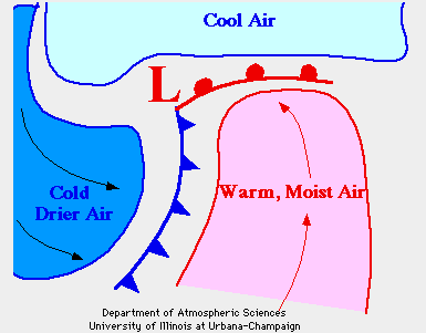
 The low pressure results as
the air rises vertically above the ground. The rising air lowers the force at
the surface, resulting in a lower pressure.
As the air rises, it cools, allowing moisture to condense into clouds and
precipitation
such as rain or snow. A low pressure system was responsible for the severe weather
which affected the upper midwest on July 18, 1996.
Air around a cyclone rotates counter-clockwise in the northern hemisphere. Warm air from the south is advected northward on the right side of the cyclone, while cooler air from the north is funneled down the left side as a cold front. As the cool air rotates around the low from the left side it runs into the warm air. The warm moist air is forced up over the cold air because it is less dense. As it rises it cools, condenses, and may form precipitation.

On July 18th there was a large temperature gradient between the two air masses and plenty of moisture in the warm sector, as it originated over the warm waters of the Gulf of Mexico where large amounts of water evaporate. The strength of storms depend on the gradient between the temperatures of the air masses and how much moisture is in the air. Meteorologists predicted the possible tornadic storms well before they moved into Wisconsin by analyzing the synoptic situation. Analyzing satellite images and radar was helpful in predicting the locations and paths of the severe thunderstorms. Predicting the exact location of where tornadoes develop is a very difficult task, thus tornadoes usually take people by surprise, resulting in numerous injuries and severe structural damage.

