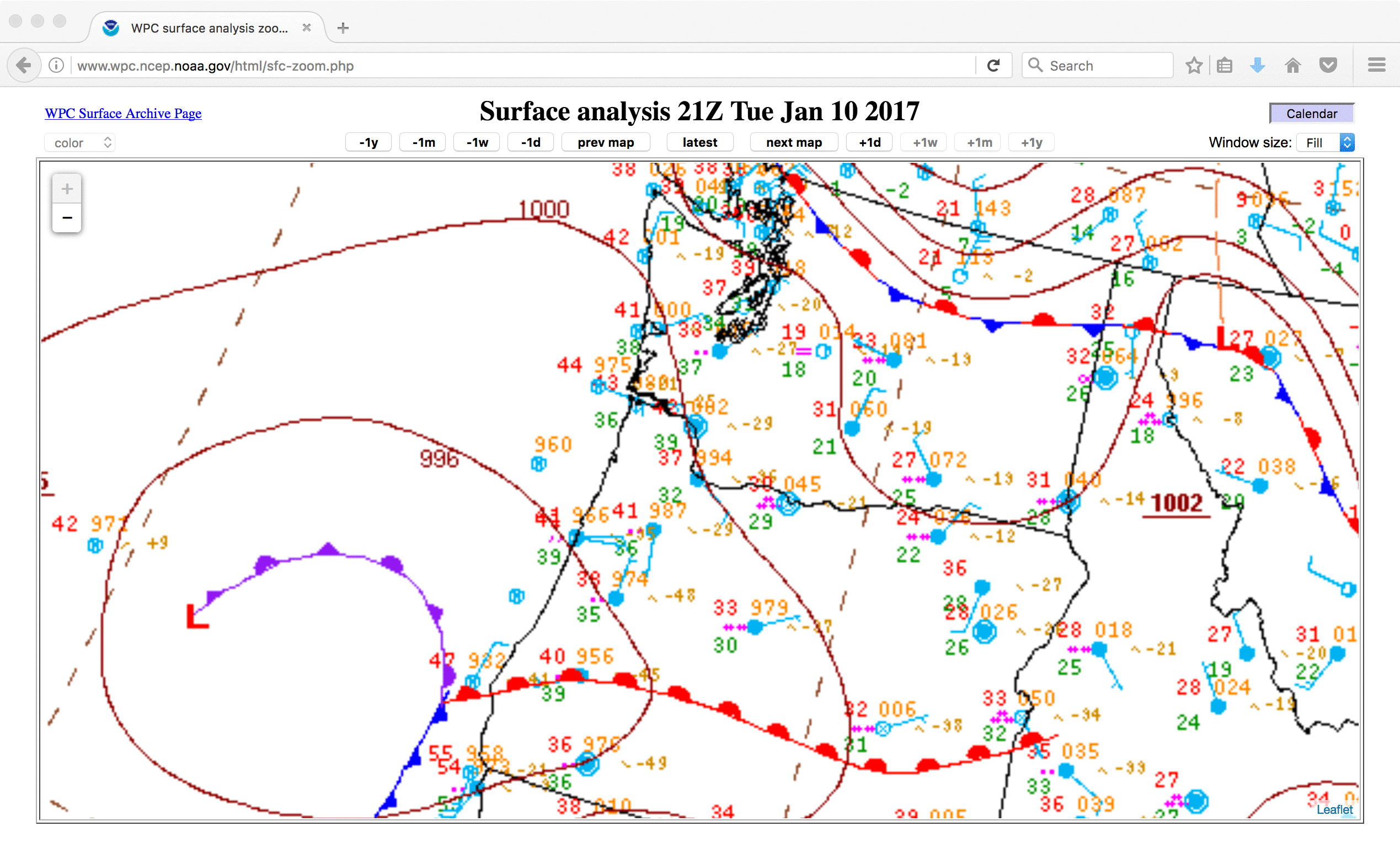
Portland, Oregon heavy snow event
![GOES-15 Infrared Window (10.7 µm) images, with hourly reports of surface weather type [click to play animation]](https://cimss.ssec.wisc.edu/satellite-blog/wp-content/uploads/sites/5/2017/01/170110-11_goes15_infrared_PDX_snow_event_anim.gif)
GOES-15 Infrared Window (10.7 µm) images, with hourly reports of surface weather type [click to play animation]
![GOES-15 Water Vapor (6.5 µm) images, with hourly reports of surface weather type [click to play animation]](https://cimss.ssec.wisc.edu/satellite-blog/wp-content/uploads/sites/5/2017/01/170110-11_goes15_water_vapor_PDX_snow_event_anim.gif)
GOES-15 Water Vapor (6.5 µm) images, with hourly reports of surface weather type [click to play animation]
![GOES-15 Visible (0.63 µm) images, with hourly reports of surface weather type [click to play animation]](https://cimss.ssec.wisc.edu/satellite-blog/wp-content/uploads/sites/5/2017/01/170110-11_goes15_visible_PDX_snow_event_anim.gif)
GOES-15 Visible (0.63 µm) images, with hourly reports of surface weather type [click to play animation]
===== 12 January Update =====
As clouds cleared in the wake of the storm, a comparison of 375-meter resolution Suomi NPP VIIRS true-color and false-color Red/Green/Blue (RGB) images viewed using RealEarth (below) revealed the extent of the snow cover; snow appears as shades of cyan in the false-color image, in contrast to clouds which appear as shades of white. [Note: with 5 inches of snow remaining on the ground, a new record low temperature was set in Portland on 13 January]
![Suomi NPP VIIRS true-color and false-color RGB images [click to enlarge]](https://cimss.ssec.wisc.edu/satellite-blog/wp-content/uploads/sites/5/2017/01/170112_2053utc_suomi_npp_viirs_truecolor_falsecolor_Portland_OR_snow_cover_anim.gif)
Suomi NPP VIIRS true-color and false-color RGB images [click to enlarge]
![Landsat-8 false-color RGB image [click to play zoom-in animation]](https://cimss.ssec.wisc.edu/satellite-blog/wp-content/uploads/sites/5/2017/01/170112_1851utc_landsat8_falsecolor_Mt_Hood_OR_anim.gif)
Landsat-8 false-color RGB image [click to play zoom-in animation]