Cold cloud top temperatures associated with Hurricane Ingrid
Hurricane Ingrid had been going though a period of slow intensification (ADT plot) off the Gulf Coast of Mexico during the overnight hours on 14 September – 15 September 2013. McIDAS images of GOES-13 10.7 µm IR channel data (above; click image to play animation) showed a few convective bursts within the central dense overcast portion of the storm, with cloud-top IR brightness temperatures as cold as -91º C (yellow color enhancement) at 04:45 UTC. These are unusually cold IR temperatures to be sensed by the coarse 4-km resolution of the IR detectors on the GOES Imager instrument.
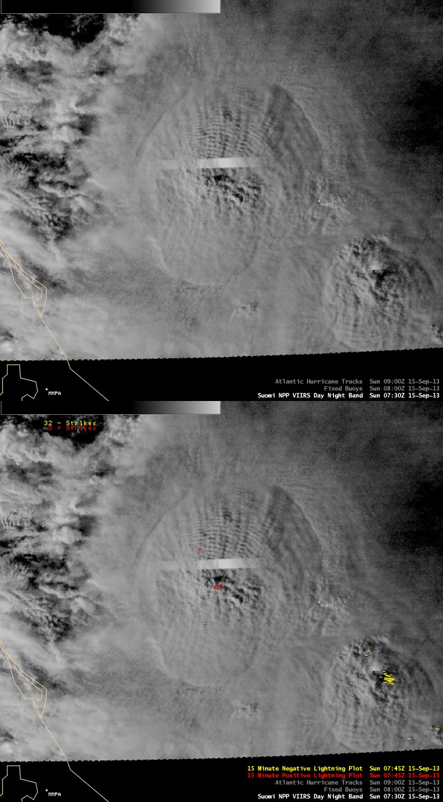
An AWIPS image comparison of 375-meter resolution (projected onto a 1-km AWIPS grid) Suomi NPP VIIRS 0.7 µm Day/Night Band (DNB) and 11.45 µm IR channel data at 07:30 UTC (below) revealed even colder cloud-top IR brightness temperatures of -95º C (darker violet color enhancement). Another feature of interest was the concentric packet of gravity waves propagating northward away from the intense overshooting tops. These cloud-top gravity waves were best seen on the DNB image, which highlights the “visible image at night” capability of this VIIRS channel data.The intese overshooting tops (produced by the rapid pulsing nature of the convective bursts seen on the GOES imagery above) were likely the source of these gravity waves.
The bright streak seen on the VIIRS DNB image was due to cloud illumination by intense lightning activity at the time the instrument was scanning that particular location. An overlay of cloud-to-ground (CG) lightning strikes for the 15-minute period ending around the time of the VIIRS overpass (below) did show a small cluster of positive polarity (red) CG strikes centered near the region of highest overshooting tops — but the bright area detected by the DNB sensor was likely due to in-cloud or cloud-to-cloud lightning.
Also evident on the VIIRS DNB image were southward-propagating mesospheric airglow waves, likely generated by the intense overshooting tops of the strong cluster of convection located to the southeast of Ingrid. Note that these mesospheric airglow waves had no signature in the corresponding 11.45 µm IR image (in contrast to the aforementioned cloud-top gravity waves north of the center of Ingrid, which could be seen on the IR image due to their effect on the topography of the convective cloud top).


