


|
|
|
|
|
|
|
|
Instruments
|
 |
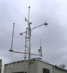
InstrumentsSee also: AERIBAGO manuals Atmospheric Emitted Radiance Interferometer (AERI)AERI (Atmospheric Emitted Radiance Interferometer) is a ground-based instrument that measures downward traveling atmospheric infrared radiation in discrete wavelengths from 3-25 µm. Scientists at CIMSS/SSEC designed this instrument, and continue to build and develop this system for use in research conducted by CIMSS/SSEC and by collaborators, including the Atmospheric Radiation Measurement (ARM) program. AERI instruments are used to conduct atmospheric temperature/moisture profiling, cloud retrieval, infrared radiance modeling and ocean-land surface remote sensing. Due to the AERI system's high temporal, vertical and spectral resolution (less than 10 minutes, 100 meters, and less than one wavenumber, respectively), the system can provide data for atmospheric stability index monitoring, planetary boundary layer research, mesoscale model initialization, verification, and nowcasting. Ground-based AERI measurements are also used to infer cloud phase, cirrus cloud absorption optical depth, cloud emissivity, and effective particle size. 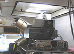 VAISALA GPS Radiosonde SystemThe AERIBAGO can deploy balloon-borne Vaisala radiosondes (RS92-SGP) that measure vertical profiles of temperature, humidity and wind. Unlike older radiosondes, this system uses GPS to track the radiosonde, thereby measuring wind speed and direction. 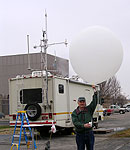 Global Positioning System (GPS) ReceiverGPS instruments are typically used to give location in relation to a constellation of satellites by measuring the delay of time clock signals. An increase in atmospheric water vapor causes an increase in satellite time signal delay because it slows down radio communication signals. This normally manifests itself as small errors in the location derived from the GPS data. If we already have an accurate location measurement, a two week average of GPS location, for instance, then we can use the variations in the delay to calculate the total amount of water vapor in the atmosphere. It is rather complicated in practice since it involves modeling the other atmospheric factors that slow down the radio signal and remapping the results since the GPS satellites are not often directly overhead. 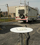 VAISALA Surface Weather StationThe AERIBAGO has a surface weather station mounted on the top of the vehicle, which can measure:
 VAISALA 25 km CeilometerStandard ceilometer that measures the altitude of the base of overhead clouds. 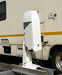 Last updated:
August 2, 2005
by SSEC
Webmaster |