Index of /satellite-blog/images/2022/09
Name
Last modified
Size
Description
Parent Directory
-
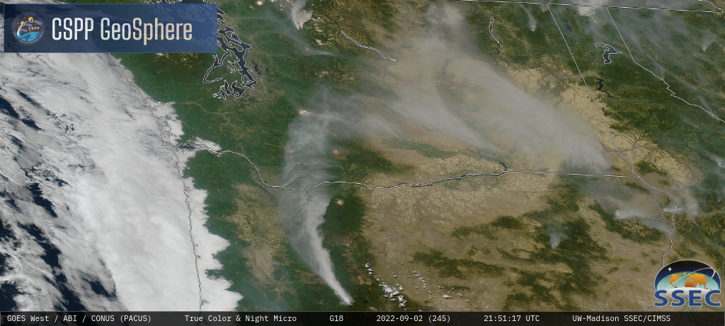
goeswest_abi_radc_true_color_night_20220902215117.png
2022-09-03 02:19
953K
goeswest_abi_radc_true_color_night_s20220902164617_e20220902215117_f60 (1).mp4
2022-09-03 02:19
927K
goeswest_abi_radc_true_color_night_s20220902164617_e20220902215117_f60.mp4
2022-09-03 02:19
927K
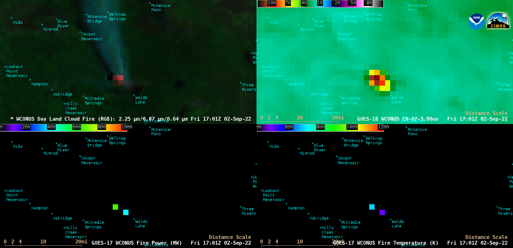
220902_goes18_dayLandCloudFireRGB_shortwaveInfrared_goes17_firePower_fireTemperature_Cedar_Creek_Fire_OR_anim.gif
2022-09-03 02:42
40M
220902_goes18_dayLandCloudFireRGB_shortwaveInfrared_goes17_firePower_fireTemperature_Cedar_Creek_Fire_OR_anim.mp4
2022-09-03 02:42
1.6M
or_4p-20220903_022117.png
2022-09-03 02:43
102K
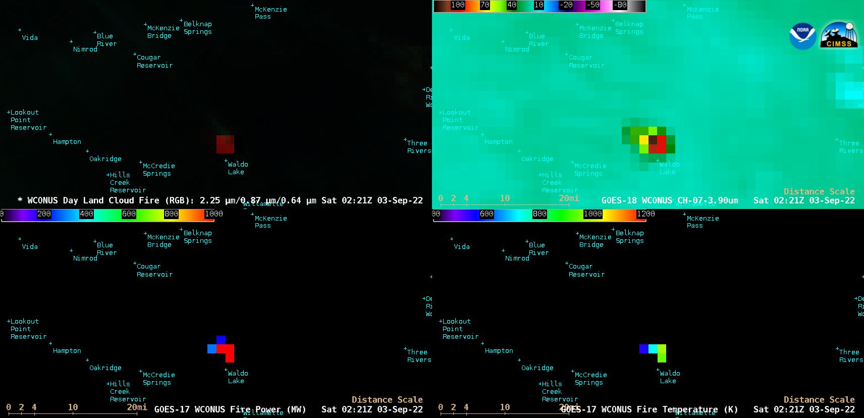
220903_goes18_dayLandCloudFireRGB_shortwaveInfrared_goes17_firePower_fireTemperature_Double_Creek_Fire_OR_anim.gif
2022-09-04 02:41
120M
220903_goes18_dayLandCloudFireRGB_shortwaveInfrared_goes17_firePower_fireTemperature_Double_Creek_Fire_OR_anim.mp4
2022-09-04 02:41
7.1M
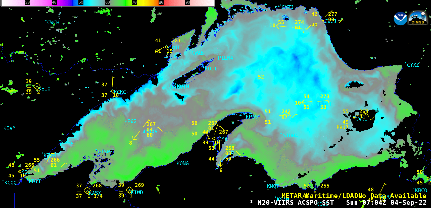
220904_viirs_seaSurfaceTemperature_Lake_Superior_anim.gf
2022-09-04 20:42
277K
220904_viirs_seaSurfaceTemperature_Lake_Superior_anim.gif
2022-09-04 20:42
827K
220904_goes18_fireTemperatureRGB_goes17_FDCA_ID_fires_anim.gif
2022-09-05 01:33
762M
220904_goes18_fireTemperatureRGB_goes17_FDCA_ID_fires_anim.mp4
2022-09-05 01:33
4.8M
220904_goes18_fireTemperatureRGB_goes17_fdcaProducts_ID_fires_anim.gif
2022-09-05 02:35
697M
220904_goes18_fireTemperatureRGB_goes17_fdcaProducts_ID_fires_anim.mp4
2022-09-05 02:35
4.8M
id_rgb-20220905_020055.png
2022-09-05 03:16
113K
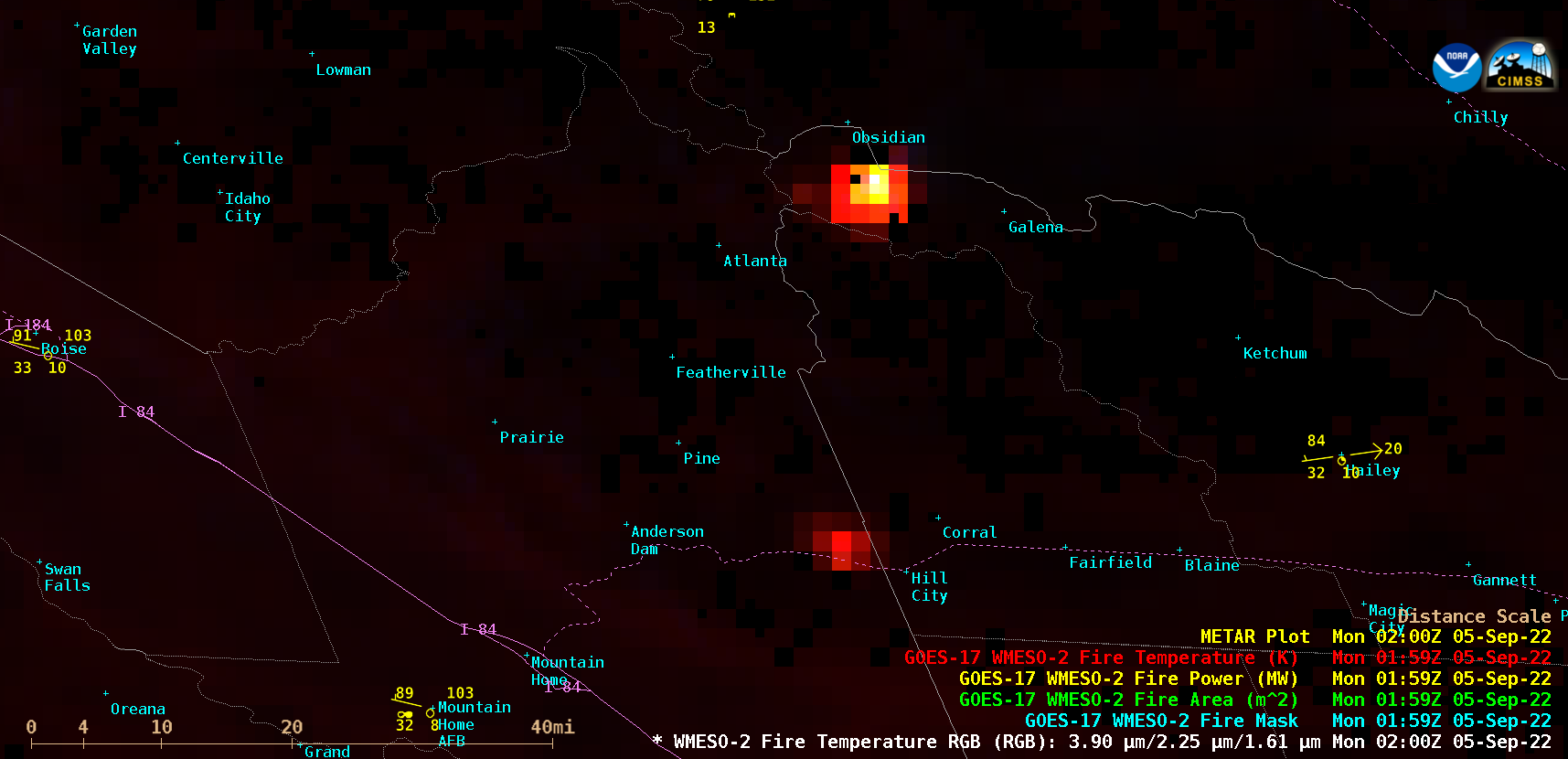
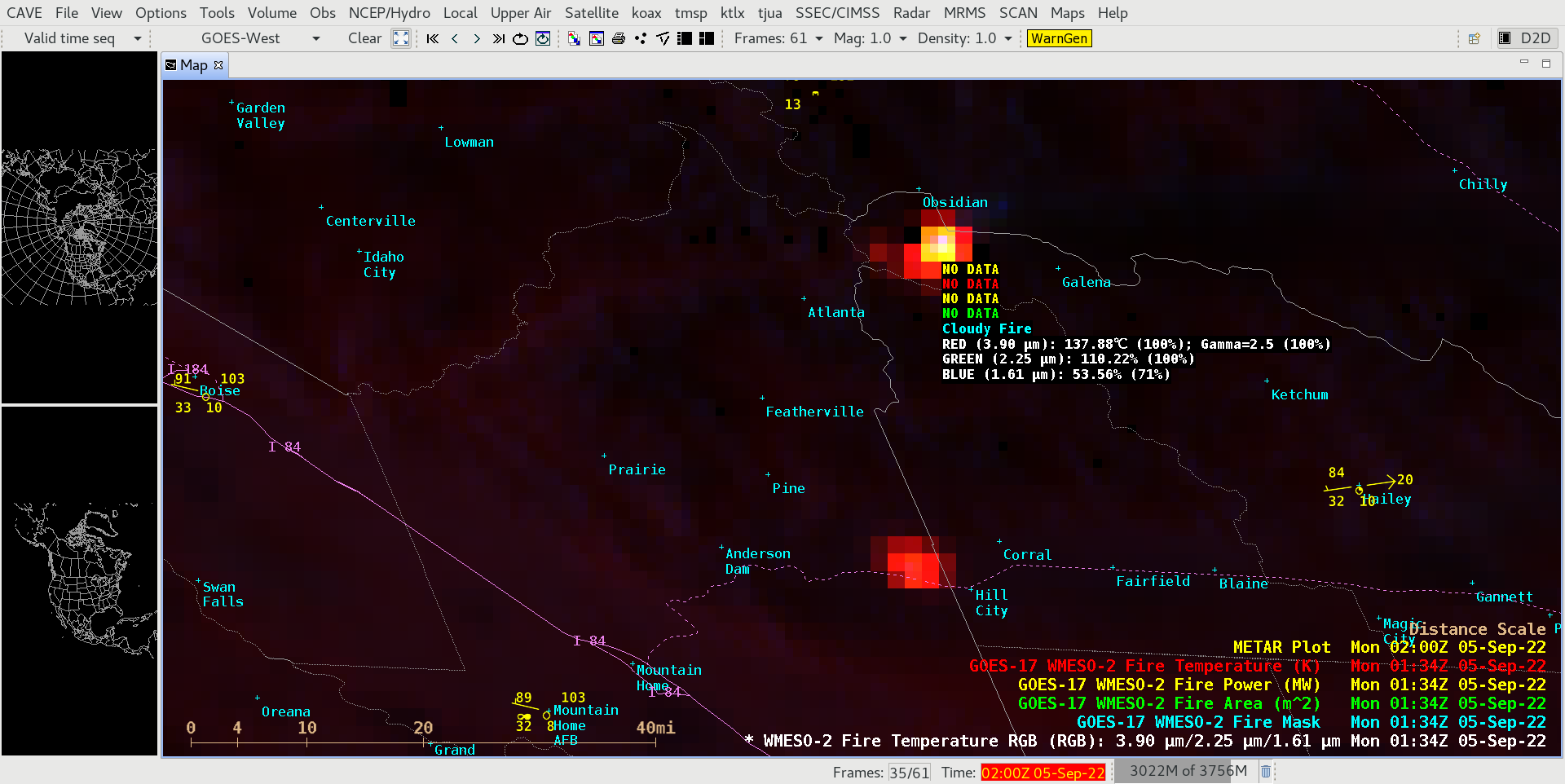
220905_0134z_rgb_cloudy_fire.png
2022-09-06 02:50
172K
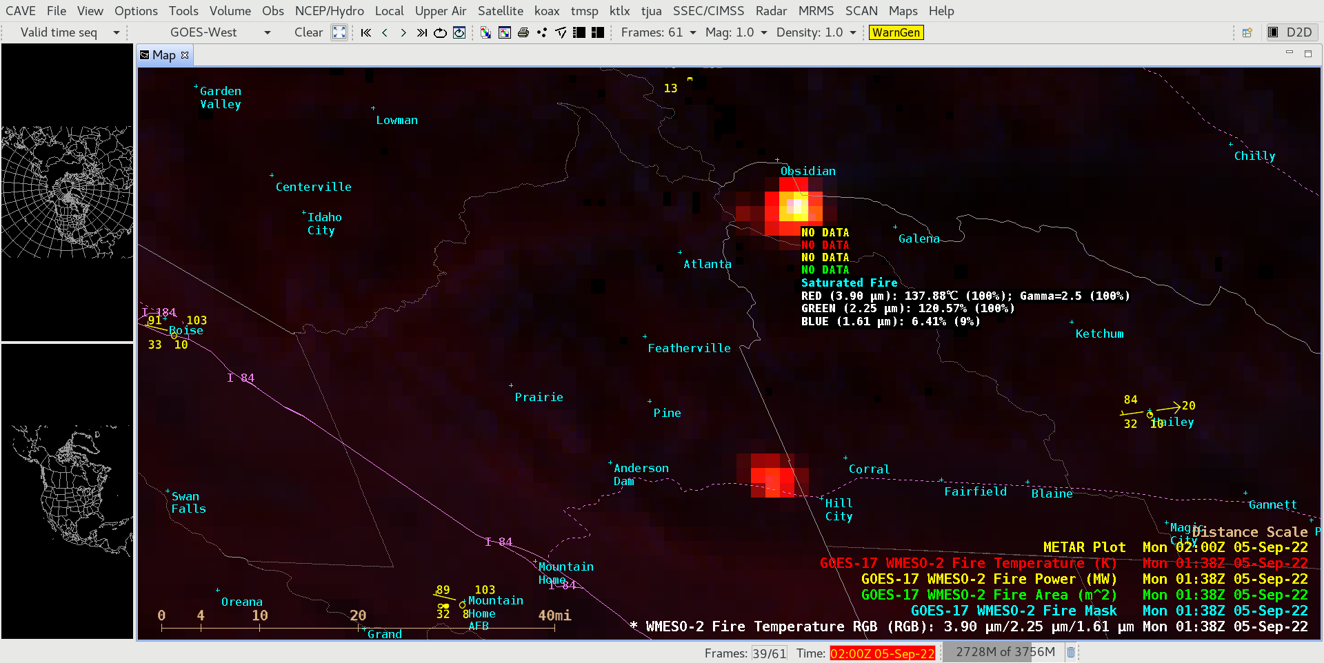
220905_0138z_rgb_saturated_fire.png
2022-09-06 02:50
171K
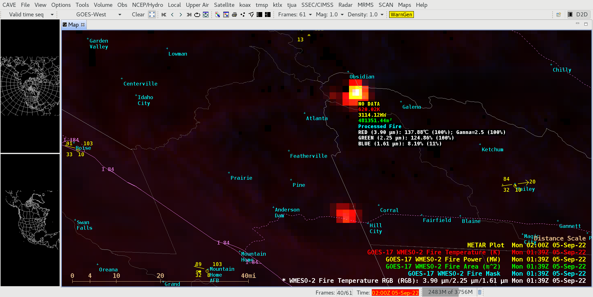
220905_0139z_rgb_processed_fire.png
2022-09-06 02:50
170K
220905_goes18_fireTemperatureRGB_goes17_FDCA_ID_fires_anim.gif
2022-09-06 19:27
693M
220905_goes18_fireTemperatureRGB_goes17_FDCA_ID_fires_anim.mp4
2022-09-06 19:27
4.5M
id2_rgb-20220906_000325.png
2022-09-06 19:30
142K
goeseast_abi_radc_true_color_night_s20220908030117_e20220908143617_f138.mp4
2022-09-08 14:49
3.7M
220907_1100utc_goes16_vis_ir_ctt_cth_Earl_anim.gif
2022-09-08 15:14
2.8M
220907_1130utc_goes16_vis_ir_ctt_cth_Earl_anim.gif
2022-09-08 15:14
2.8M
220907_1200utc_goes16_vis_ir_ctt_cth_Earl_anim.gif
2022-09-08 15:14
2.8M
220907_1200utc_goes16_vis_ir_ctt_cth_Earl_anim.mp4
2022-09-08 15:14
1.6M
or_id_fires_rgb-20220907_224617.png
2022-09-08 19:24
445K
220907_goes18_dayLandCloudFiresRGB_shortwaveInfrared_infraredWindow_cloudTopTemperature_ID_pyroCb_anim.gif
2022-09-08 20:07
160M
220907_goes18_dayLandCloudFiresRGB_shortwaveInfrared_infraredWindow_cloudTopTemperature_ID_pyroCb_anim.mp4
2022-09-08 20:07
20M
220907_goes18_fireTemperatureRGB_OR_ID_pyroCB_anim.gif
2022-09-08 20:07
78M
220907_goes18_fireTemperatureRGB_OR_ID_pyroCB_anim.mp4
2022-09-08 20:07
6.4M
id_4p-20220907_234225.png
2022-09-09 15:57
331K
220907_goes18_dayLandCloudFireRGB_OR_ID_pyroCB_anim.gif
2022-09-09 19:08
78M
220907_goes18_dayLandCloudFireRGB_OR_ID_pyroCB_anim.mp4
2022-09-09 19:08
6.4M
220910_1020utc_suomiNPP_viirs_dayNightBand_Cedar_Creek_Fire_OR_smoke_plume.png
2022-09-10 18:18
515K
220910_1020utc_suomiNPP_viirs_goes17_shortwaveInfrared_Cedar_Creek_Fire_OR_anim.gif
2022-09-10 18:18
798K
220910_1020utc_suomiNPP_viirs_shortwaveInfrared_dayNightBand_Cedar_Creek_Fire_OR_anim.gif
2022-09-10 18:18
808K
G17_VIS_SWIR_IR_CA_PYROCB_08SEP2022_B2713_2022251_212025_0003PANELS_FRAME00001.GIF
2022-09-11 00:19
309K
220910_goes17_dayLandCloudFireRGB_shortwaveInfrared_infraredWindow_cloudTopTemperature_Cedar_Creek_Fire_OR_pyroCb_anim.gif
2022-09-11 03:52
185M
220910_goes17_dayLandCloudFireRGB_shortwaveInfrared_infraredWindow_cloudTopTemperature_Cedar_Creek_Fire_OR_pyroCb_anim.mp4
2022-09-11 03:52
6.5M
220911_1002utc_suomiNPP_viirs_dayNightBand_shortwaveInfrared_Cedar_Creek_Fire_OR_anim.gif
2022-09-11 20:33
314K
220911_1002utc_suomiNPP_viirs_dayNightBand_shortwaveInfrared_Cedar_Creek_Fire_OR_anim.mp4
2022-09-11 20:33
344K
220911_1002utc_suomiNPP_viirs_goes17_shortwaveInfrared_Cedar_Creek_Fire_OR_anim.mp4
2022-09-11 20:33
530K
220906_drought_monitor.png
2022-09-12 01:57
76K
220908_goes17_visible_shortwaveInfrared_infraredWindow_CA_pyroCb_anim.gif
2022-09-12 03:46
87M
220908_goes17_visible_shortwaveInfrared_infraredWindow_CA_pyroCb_anim.mp4
2022-09-12 03:46
23M
goeswest_abi_radm1_true_color_night_20220911002925.png
2022-09-12 17:13
464K
goeswest_abi_radc_true_color_night_s20220909194617_e20220910004117_f60.mp4
2022-09-12 17:14
236K
goeswest_abi_radm1_true_color_night_s20220910233025_e20220911002925_f60.mp4
2022-09-12 17:14
296K
goeswest_abi_radm1_true_color_night_20220908221425.png
2022-09-12 17:14
706K
goeswest_abi_radm1_true_color_night_s20220908212025_e20220908224925_f90.mp4
2022-09-12 17:14
741K
goeswest_abi_radm1_true_color_night_s20220908212025_e20220908231925_f120.mp4
2022-09-12 17:14
1.0M
or_ctt-20220911_004325.png
2022-09-12 18:41
54K
or_ir-20220911_004325.png
2022-09-12 18:41
70K
or_rgb-20220911_004325.png
2022-09-12 18:41
151K
or_swir-20220911_004325.png
2022-09-12 18:41
75K
220911_1002utc_suomiNPP_viirs_goes17_shortwaveInfrared_Cedar_Creek_Fire_OR_anim.gif
2022-09-12 19:21
824K
G17_VIS_SWIR_IR_CA_PYROCB_08SEP2022_B2713_2022251_220325_0003PANELS_FRAME00044.GIF
2022-09-12 21:42
319K
goeswest_abi_radm1_true_color_night_20220907214525.png
2022-09-13 02:54
600K
goeswest_abi_radm1_true_color_night_20220907222625.png
2022-09-13 02:54
698K
goeswest_abi_radm1_true_color_night_s20220907210027_e20220907215925_f60.mp4
2022-09-13 02:54
819K
goeswest_abi_radm1_true_color_night_s20220907210027_e20220907232325_f144.mp4
2022-09-13 02:54
1.6M
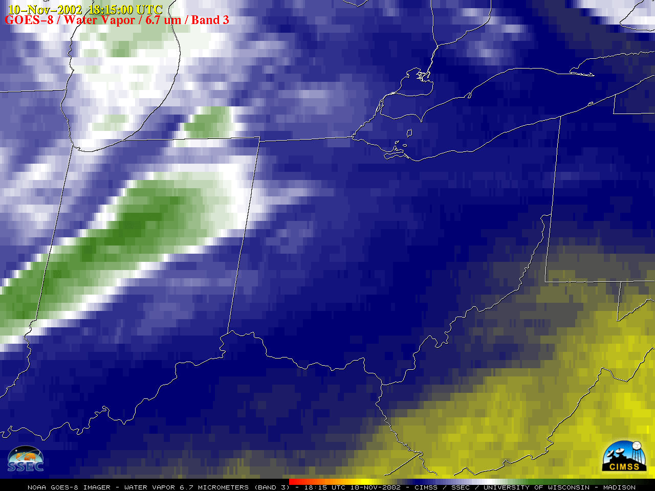
G08_VIS_IN_OH_PA_SVR_10NOV2002_B1_2002314_181500_GOES-8_0001PANEL_FRAME00001.GIF
2022-09-14 00:38
454K
G08_VIS_IN_OH_PA_SVR_10NOV2002_B1_2002314_182500_GOES-8_0001PANEL_FRAME00002.GIF
2022-09-14 00:38
443K
G08_VIS_IN_OH_PA_SVR_10NOV2002_B1_2002314_184500_GOES-8_0001PANEL_FRAME00003.GIF
2022-09-14 00:38
455K
G08_VIS_IN_OH_PA_SVR_10NOV2002_B1_2002314_185500_GOES-8_0001PANEL_FRAME00004.GIF
2022-09-14 00:38
446K
G08_VIS_IN_OH_PA_SVR_10NOV2002_B1_2002314_190200_GOES-8_0001PANEL_FRAME00005.GIF
2022-09-14 00:38
453K
G08_VIS_IN_OH_PA_SVR_10NOV2002_B1_2002314_191000_GOES-8_0001PANEL_FRAME00006.GIF
2022-09-14 00:38
442K
G08_VIS_IN_OH_PA_SVR_10NOV2002_B1_2002314_191500_GOES-8_0001PANEL_FRAME00007.GIF
2022-09-14 00:38
433K
G08_VIS_IN_OH_PA_SVR_10NOV2002_B1_2002314_192500_GOES-8_0001PANEL_FRAME00008.GIF
2022-09-14 00:38
441K
G08_VIS_IN_OH_PA_SVR_10NOV2002_B1_2002314_193200_GOES-8_0001PANEL_FRAME00009.GIF
2022-09-14 00:38
425K
G08_VIS_IN_OH_PA_SVR_10NOV2002_B1_2002314_194000_GOES-8_0001PANEL_FRAME00010.GIF
2022-09-14 00:38
410K
G08_VIS_IN_OH_PA_SVR_10NOV2002_B1_2002314_194500_GOES-8_0001PANEL_FRAME00011.GIF
2022-09-14 00:38
412K
G08_VIS_IN_OH_PA_SVR_10NOV2002_B1_2002314_195500_GOES-8_0001PANEL_FRAME00012.GIF
2022-09-14 00:38
413K
G08_VIS_IN_OH_PA_SVR_10NOV2002_B1_2002314_200200_GOES-8_0001PANEL_FRAME00013.GIF
2022-09-14 00:38
394K
G08_VIS_IN_OH_PA_SVR_10NOV2002_B1_2002314_201000_GOES-8_0001PANEL_FRAME00014.GIF
2022-09-14 00:38
389K
G08_VIS_IN_OH_PA_SVR_10NOV2002_B1_2002314_201500_GOES-8_0001PANEL_FRAME00015.GIF
2022-09-14 00:38
383K
G08_VIS_IN_OH_PA_SVR_10NOV2002_B1_2002314_202500_GOES-8_0001PANEL_FRAME00016.GIF
2022-09-14 00:38
383K
G08_VIS_IN_OH_PA_SVR_10NOV2002_B1_2002314_203200_GOES-8_0001PANEL_FRAME00017.GIF
2022-09-14 00:38
376K
G08_VIS_IN_OH_PA_SVR_10NOV2002_B1_2002314_204000_GOES-8_0001PANEL_FRAME00018.GIF
2022-09-14 00:38
374K
021110_goes8_visible_IN_OH_PA_anim.gif
2022-09-14 01:37
15M
021110_goes8_visible_IN_OH_PA_anim.mp4
2022-09-14 01:37
4.8M
021110_goes8_visible_spcStormReports_IN_OH_PA_anim.gif
2022-09-14 01:37
15M
021110_goes8_visible_spcStormReports_IN_OH_PA_anim.mp4
2022-09-14 01:37
4.8M
220914_0951utc_noaa20_viirs_goes17_abi_shortwaveInfrared_Mosquito_Fire_CA_anim.gif
2022-09-14 17:40
672K
220914_0951utc_noaa20_viirs_goes17_abi_shortwaveInfrared_Mosquito_Fire_CA_anim.mp4
2022-09-14 17:40
497K
220914_0951utc_noaa20_viirs_shortwaveInfrared_dayNightBand_Mosquito_Fire_CA_anim.gif
2022-09-14 17:40
671K
220914_0951utc_noaa20_viirs_shortwaveInfrared_dayNightBand_Mosquito_Fire_CA_anim.mp4
2022-09-14 17:40
634K
G17_VIS_SWIR_CA_FIRE_14SEP2022_B27_2022257_210025_0002PANELS_FRAME00001.GIF
2022-09-15 03:32
315K
220914_goes17_visible_shortwaveInfrared_Mosquito_Fire_CA_anim.gif
2022-09-15 18:33
229M
220914_goes17_visible_shortwaveInfrared_Mosquito_Fire_CA_anim.mp4
2022-09-15 18:33
6.1M
220915_1028utc_suomiNPP_viirs_shortwaveInfrared_dayNightBand_Mosquito_Fire_CA_anim.gif
2022-09-15 18:33
788K
220915_1028utc_suomiNPP_viirs_shortwaveInfrared_dayNightBand_Mosquito_Fire_CA_anim.mp4
2022-09-15 18:33
722K
2209013_suomiNPP_viirs_visible_Beaufort_Sea_2_anim.gif
2022-09-15 20:22
3.5M
2209013_suomiNPP_viirs_visible_Beaufort_Sea_2_anim.mp4
2022-09-15 20:22
2.4M
2209013_suomiNPP_viirs_visible_Beaufort_Sea_anim.gif
2022-09-15 20:22
2.6M
2209013_suomiNPP_viirs_visible_Beaufort_Sea_anim.mp4
2022-09-15 20:22
2.3M
220913_1917utc_n20_fc.png
2022-09-16 02:36
2.7M
220913_2008utc_snpp_fc.png
2022-09-16 02:36
2.6M
220913_2058utc_n20_fc.png
2022-09-16 02:36
2.6M
220913_2150utc_snpp_fc.png
2022-09-16 02:36
2.5M
220913_2239utc_n20_fc.png
2022-09-16 02:36
2.5M
220913_0000utc_seaIceConcentration.png
2022-09-16 02:37
1.5M
220913_noaa20_suomiNPP_viirs_falseColorRGB_Beaufort_Sea_Chukchi_Sea_ice_anim.gif
2022-09-16 02:41
5.8M
beau_vis2-20220913_204801.png
2022-09-16 02:58
920K
beau_vis-20220913_204801.png
2022-09-16 02:59
1.1M
ak_rgb_metar-20220916_170031.png
2022-09-16 17:44
1.7M
HIM08_IR_NANMADOL_16SEP2022_B13_2022259_120215_HIMAWARI-8_0001PANEL_FRAME00001.GIF
2022-09-16 20:40
235K
220916_himawari8_visible_STY_Nanmadol_sunrise_anim.gif
2022-09-16 22:30
12M
220916_himawari8_visible_STY_Nanmadol_sunrise_anim.mp4
2022-09-16 22:30
2.2M
HIM08_IR_NANMADOL_16SEP2022_B13_2022259_233441_HIMAWARI-8_0001PANEL_FRAME00029.GIF
2022-09-17 03:27
202K
220916_himawari8_visible_STY_Nanmadol_anim.gif
2022-09-17 18:41
57M
220916_himawari8_visible_STY_Nanmadol_anim.mp4
2022-09-17 18:41
4.5M
220916_himawari8_visible_STY_Nanmadol_cliff_anim.gif
2022-09-17 18:41
13M
220916_himawari8_visible_STY_Nanmadol_cliff_anim.mp4
2022-09-17 18:41
2.8M
220916_himawari8_infrared_STY_Nanmadol_anim.gif
2022-09-17 18:47
90M
220916_himawari8_infrared_STY_Nanmadol_anim.mp4
2022-09-17 18:47
28M
220916_himawari8_infrared_STY_Nanmadol_cliff_anim.gif
2022-09-17 19:17
8.4M
220916_himawari8_infrared_STY_Nanmadol_cliff_anim.mp4
2022-09-17 19:17
1.1M
220917_0122utc_himawari8_visible_infrared_STY_Nanmadol_cliff_anim.gif
2022-09-17 19:24
388K
220916_goes17_airMassRGB_exMerbok_Bering_Sea_anim.mp4
2022-09-18 00:06
26M
220916_goes17_airMassRGB_exMerbok_Bering_Sea_anim.gif
2022-09-18 00:11
160M
220916_goes17_airMassRGB_exMerbok_Bering_Sea_small_anim.mp4
2022-09-18 00:11
13M
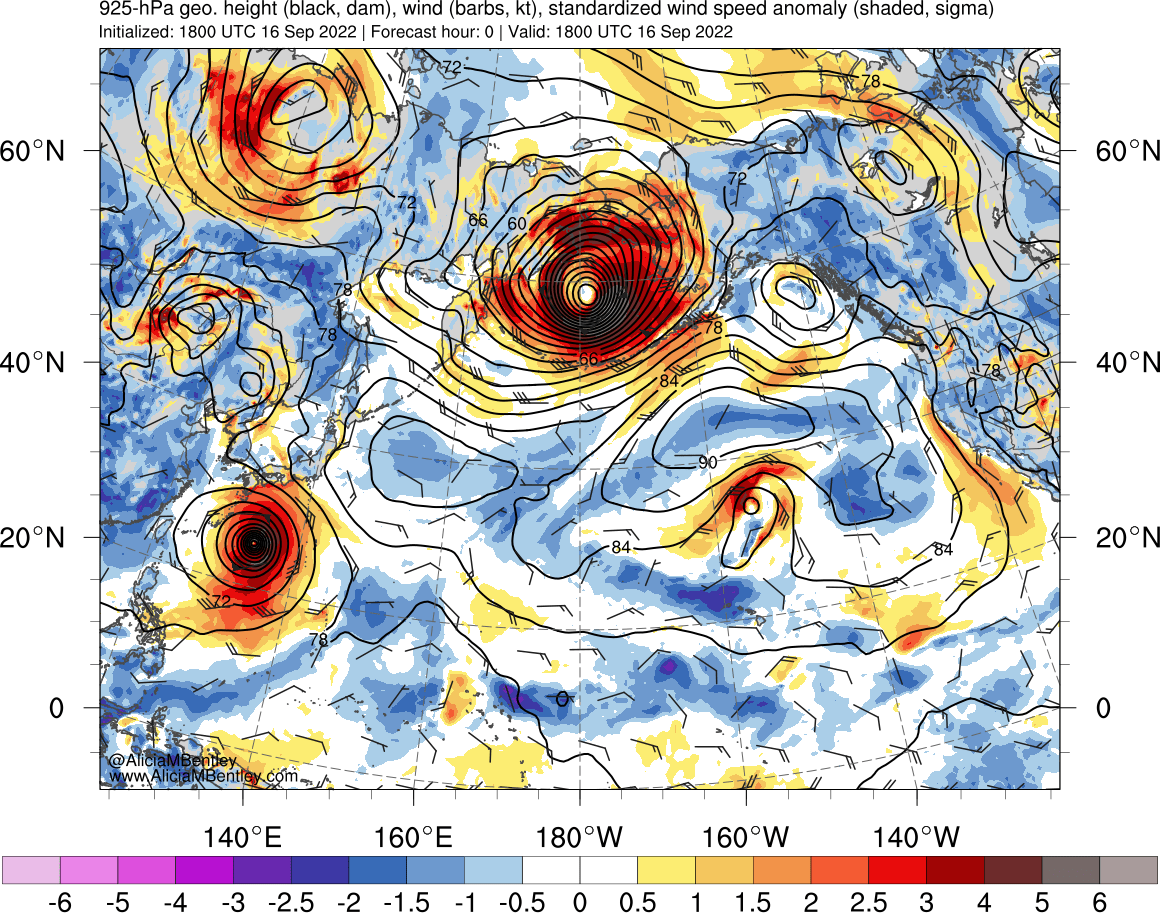
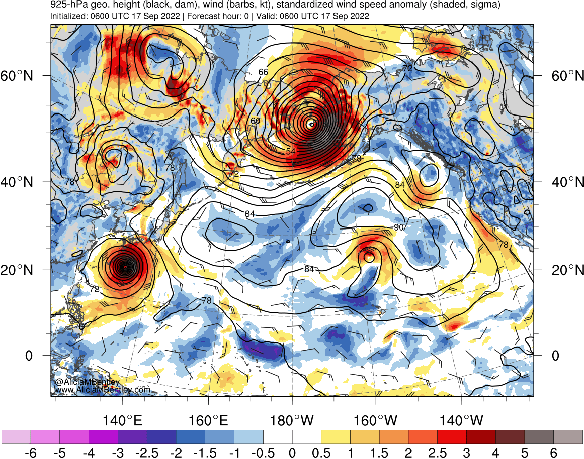
220916_00z_925winds_anom.png
2022-09-18 01:06
248K
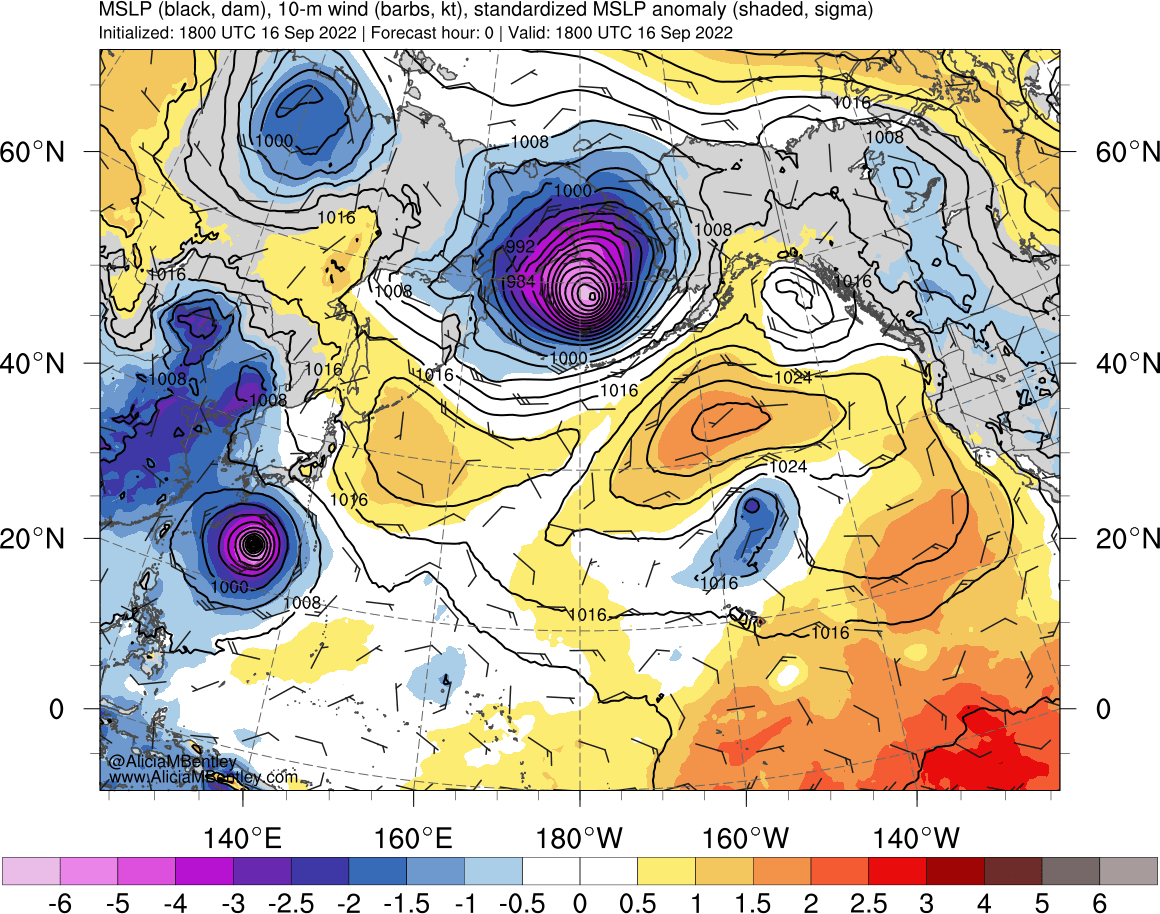
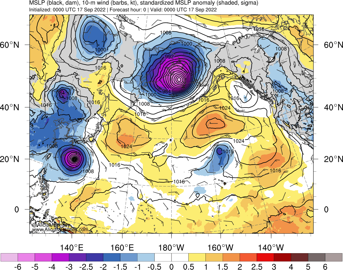
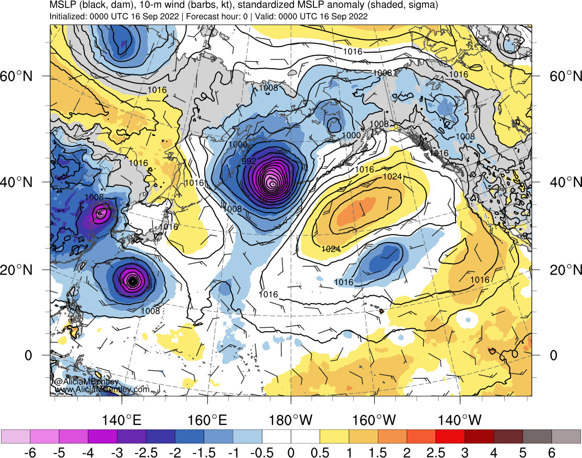
220916_00z_mslp_anom.png
2022-09-18 01:06
222K
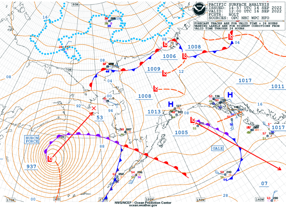
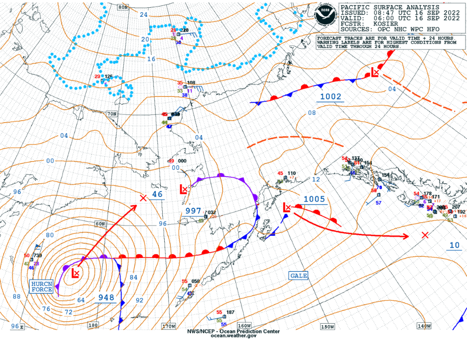
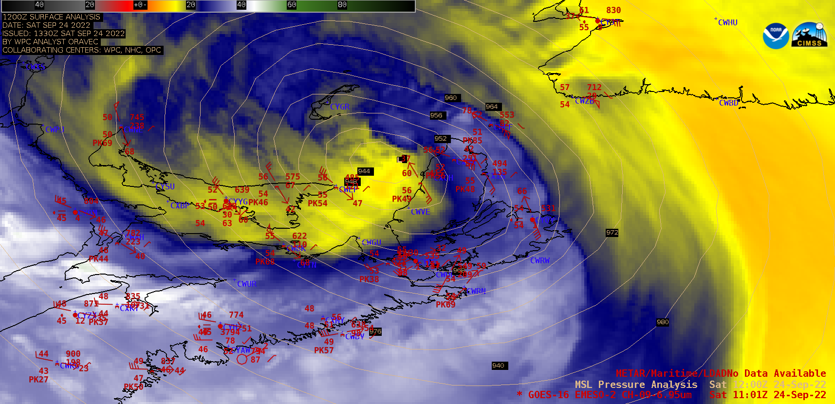
220916_00z_sfc.png
2022-09-18 01:06
778K
220916_06z_925winds_anom.png
2022-09-18 01:06
246K
220916_06z_mslp_anom.png
2022-09-18 01:06
221K
220916_12z_925winds_anom.png
2022-09-18 01:06
249K
220916_12z_mslp_anom.png
2022-09-18 01:06
223K
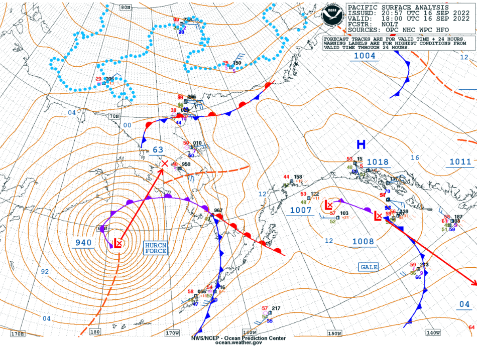
220916_12z_sfc.png
2022-09-18 01:06
821K
220916_18z_925winds_anom.png
2022-09-18 01:06
251K
220916_18z_mslp_anom.png
2022-09-18 01:06
218K
220916_18z_sfc.png
2022-09-18 01:06
827K
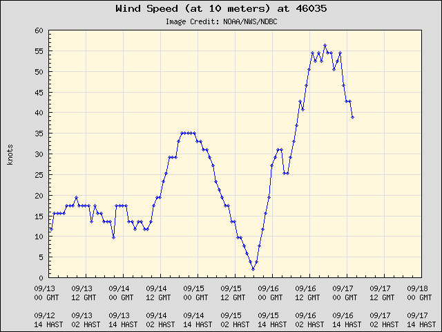
220916_buoy46035_10mwind_speed.png
2022-09-18 01:06
8.9K
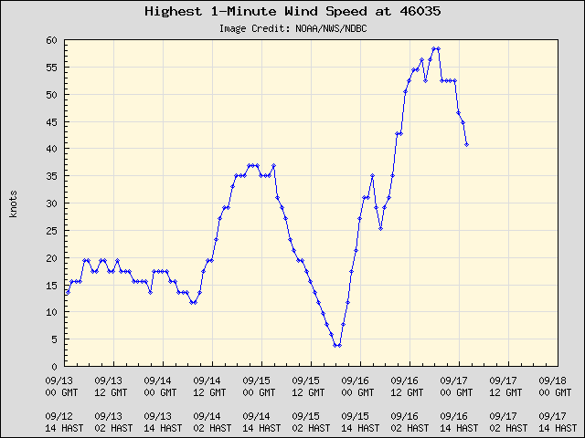
220916_buoy46035_1minute_winds.png
2022-09-18 01:06
8.9K
220916_buoy46035_20mwind_speed.png
2022-09-18 01:06
9.1K
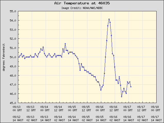
220916_buoy46035_air_temperature.png
2022-09-18 01:06
8.7K
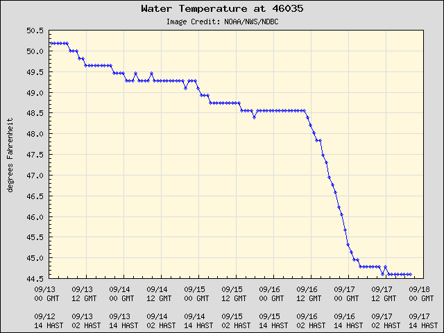
220916_buoy46035_water_temperature.png
2022-09-18 01:06
8.3K
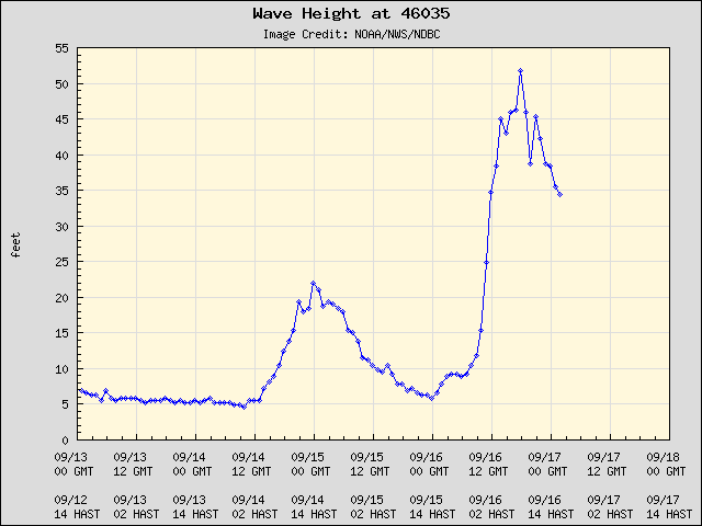
220916_buoy46035_waveHeight.png
2022-09-18 01:06
8.3K
220916_buoy46035_wind_gusts.png
2022-09-18 01:06
8.0K
220916_buoy46035_wind_speed.png
2022-09-18 01:06
13K
220916_buoy46035_winds_pressure.png
2022-09-18 01:06
15K
220916_buoy46045_1minute_winds.png
2022-09-18 01:06
9.2K
220916_buoy46045_waveHeight.png
2022-09-18 01:06
8.6K
220916_buoy46045_winds_pressure.png
2022-09-18 01:06
15K
220916_buoy46071_waveHeight.png
2022-09-18 01:06
7.6K
220916_buoy46071_winds_pressure.png
2022-09-18 01:06
18K
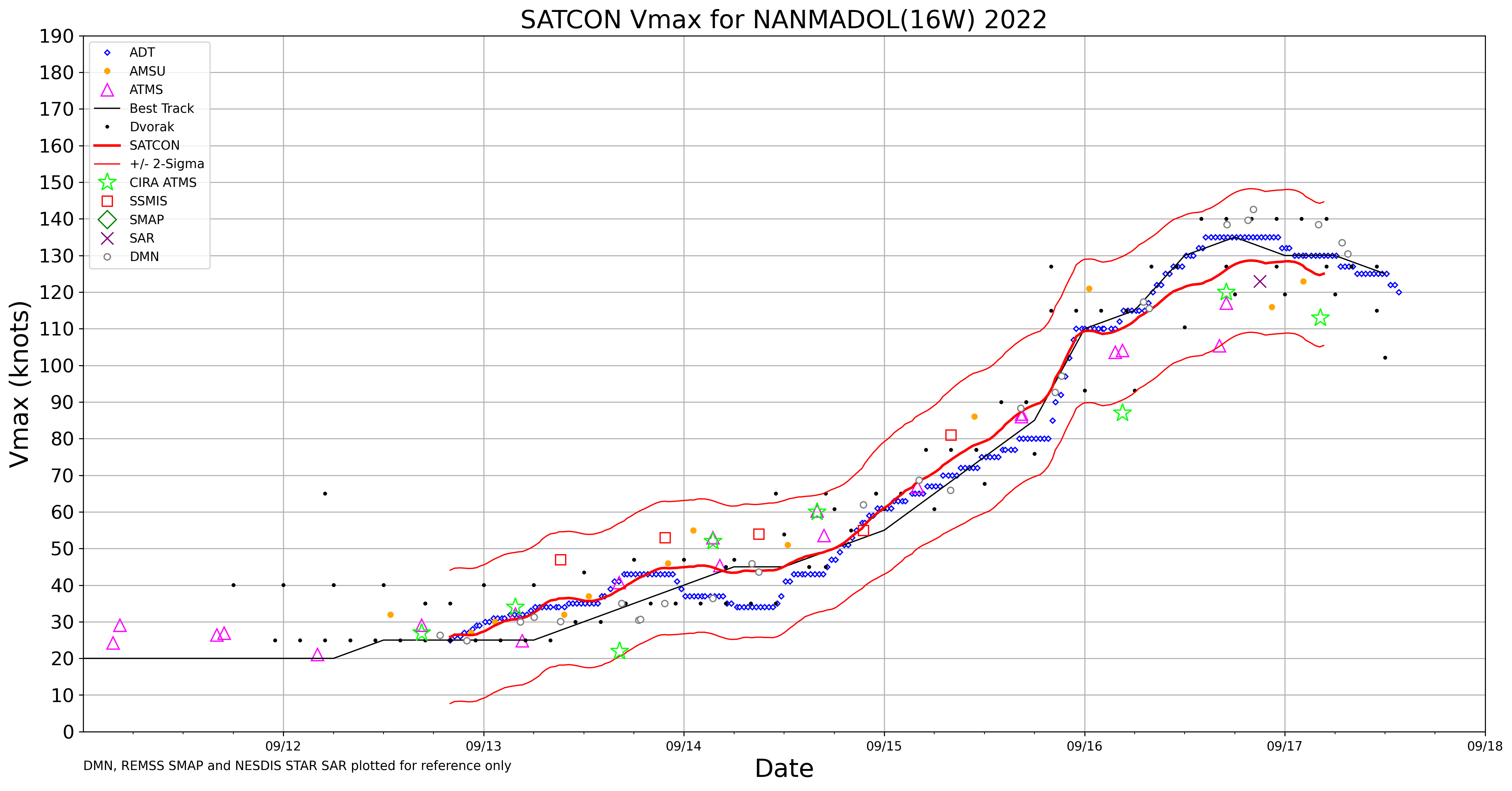
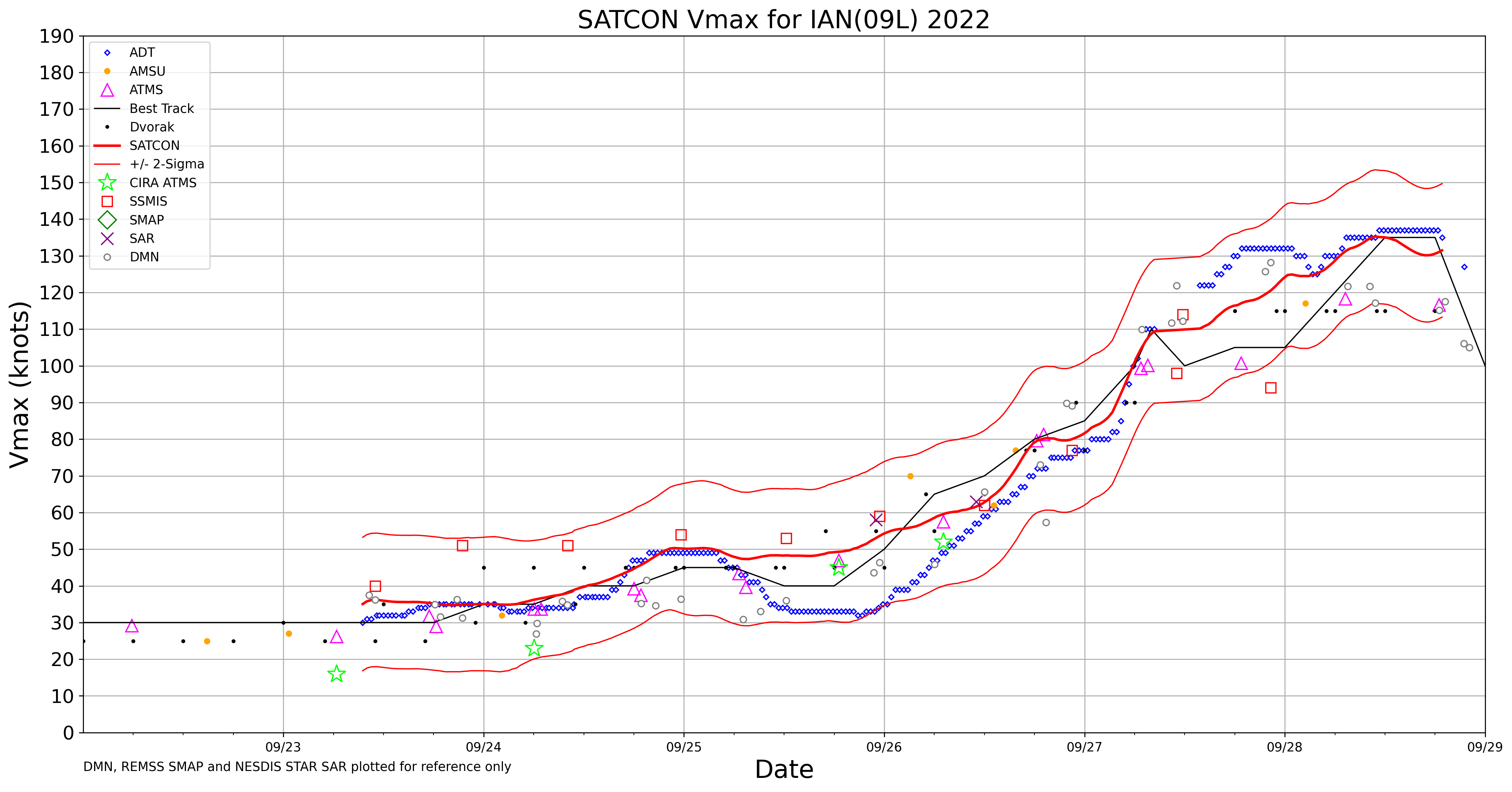
220916_satcon.png
2022-09-18 01:06
431K
220917_00z_925winds_anom.png
2022-09-18 01:07
252K
220917_00z_mslp_anom.png
2022-09-18 01:07
224K
220917_00z_sfc.png
2022-09-18 01:07
810K
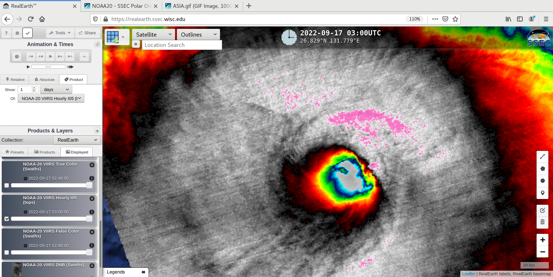
220917_0341utc_noaa20_infrared_STY_Nanmadol.png
2022-09-18 01:07
1.0M
220917_06z_925winds_anom.png
2022-09-18 01:07
250K
220917_06z_mslp_anom.png
2022-09-18 01:07
222K
220917_06z_sfc.png
2022-09-18 01:07
800K
220917_12z_925winds_anom.png
2022-09-18 01:07
248K
220917_12z_mslp_anom.png
2022-09-18 01:07
224K
220917_12z_sfc.png
2022-09-18 01:07
782K
220917_18z_925winds_anom.png
2022-09-18 01:07
251K
220917_18z_mslp_anom.png
2022-09-18 01:07
219K
220917_18z_sfc.png
2022-09-18 01:07
787K
220917_buoy46035_water_temperature.png
2022-09-18 01:07
8.5K
220916_220917_surface_analyses_anim.gif
2022-09-18 01:29
2.2M
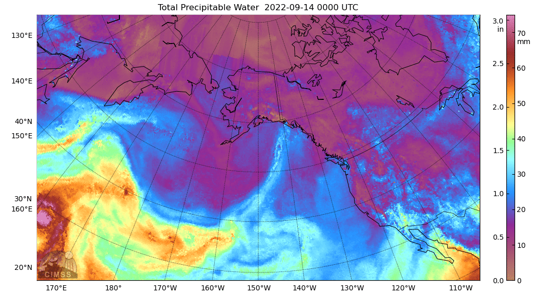
220914_220917_mimicTPW_anim.gif
2022-09-18 01:58
31M
220914_220917_mimicTPW_anim.mp4
2022-09-18 01:58
6.7M
220916_220917_925hPaWindSpeedAnomaly_anim.gif
2022-09-18 02:36
2.6M
220916_220917_meanSeaLevelPressureAnomaly_anim.gif
2022-09-18 02:36
2.3M
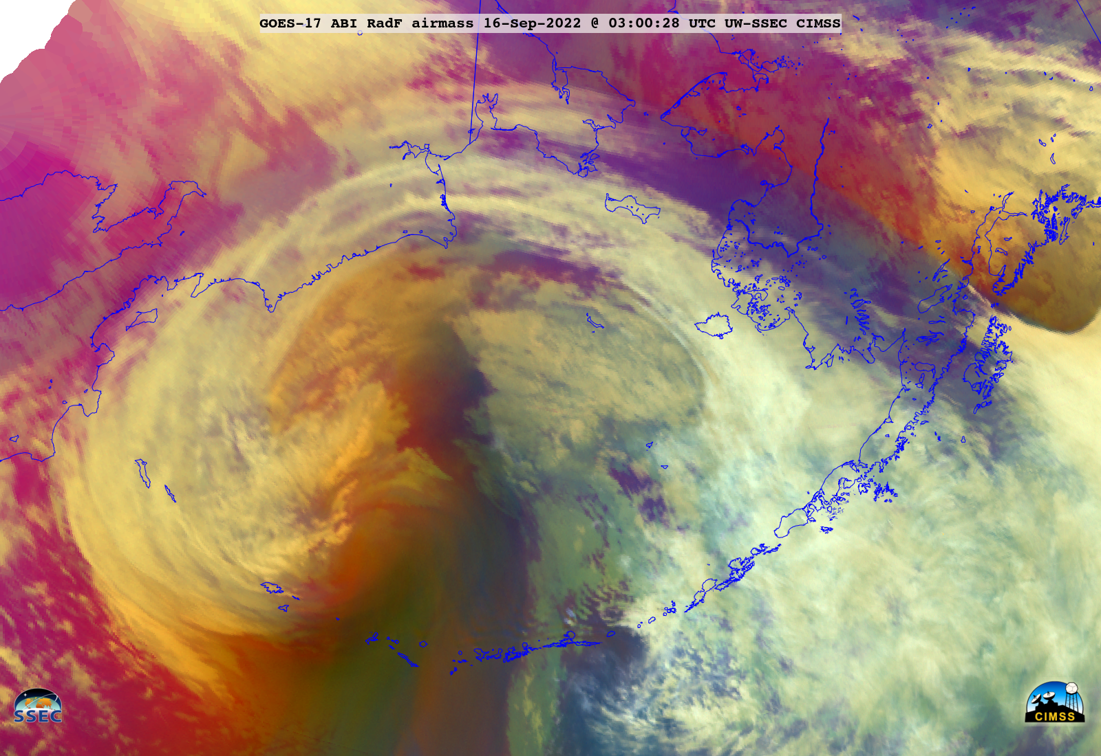
GOES-17_ABI_RadF_airmass_2022258_210028Z.png
2022-09-18 19:04
1.4M
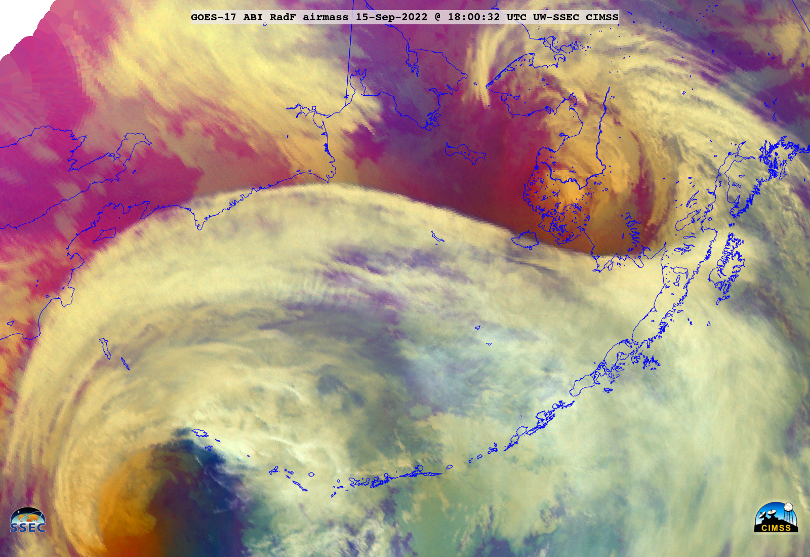
GOES-17_ABI_RadF_airmass_2022258_180032Z.png
2022-09-18 19:12
2.1M
220918_goes16_visible_infrared_Hurricane_Fiona_anim.mp4
2022-09-18 20:47
27M
220918_goes16_cloudTopTemperature_cloudTopHeight_Hurricane_Fiona_anim.mp4
2022-09-18 21:05
37M
220918_goes16_cloudTopTemperature_cloudTopHeight_Hurricane_Fiona_anim.gif
2022-09-18 21:16
358M
220918_goes16_cloudTopTemperature_cloudTopHeight_Hurricane_Fiona_small_anim.mp4
2022-09-18 21:16
16M
220918_goes16_visible_infrared_Hurricane_Fiona_anim.gif
2022-09-18 21:16
350M
220918_goes16_visible_infrared_Hurricane_Fiona_small_anim.mp4
2022-09-18 21:16
9.4M
fiona_cth-20220918_150027.png
2022-09-18 21:35
137K
fiona_ctt-20220918_150027.png
2022-09-18 21:35
247K
fiona_ir-20220918_150027.png
2022-09-18 21:35
238K
fiona_vis-20220918_150027.png
2022-09-18 21:35
756K
ak_pv-20220916_170031.png
2022-09-18 22:06
1.8M
220916_goes17_airMassRGB_akNAM40_pv1.5pressure_exMerbok_Bering_Sea_anim.gif
2022-09-18 22:29
142M
220916_goes17_airMassRGB_akNAM40_pv1.5pressure_exMerbok_Bering_Sea_anim.mp4
2022-09-18 22:29
23M
ak_rgb_metar-20220916_180031.png
2022-09-18 23:52
1.7M
ak_rgb_metar-20220916_190031.png
2022-09-18 23:53
1.7M
220915_220917_goes17_airMassRGB_Bering_Sea_anim.mp4
2022-09-19 00:37
25M
220915_220917_goes17_airMassRGB_Bering_Sea_anim.gif
2022-09-19 01:01
324M
220915_220917_goes17_airMassRGB_Bering_Sea_small_anim.mp4
2022-09-19 01:01
16M
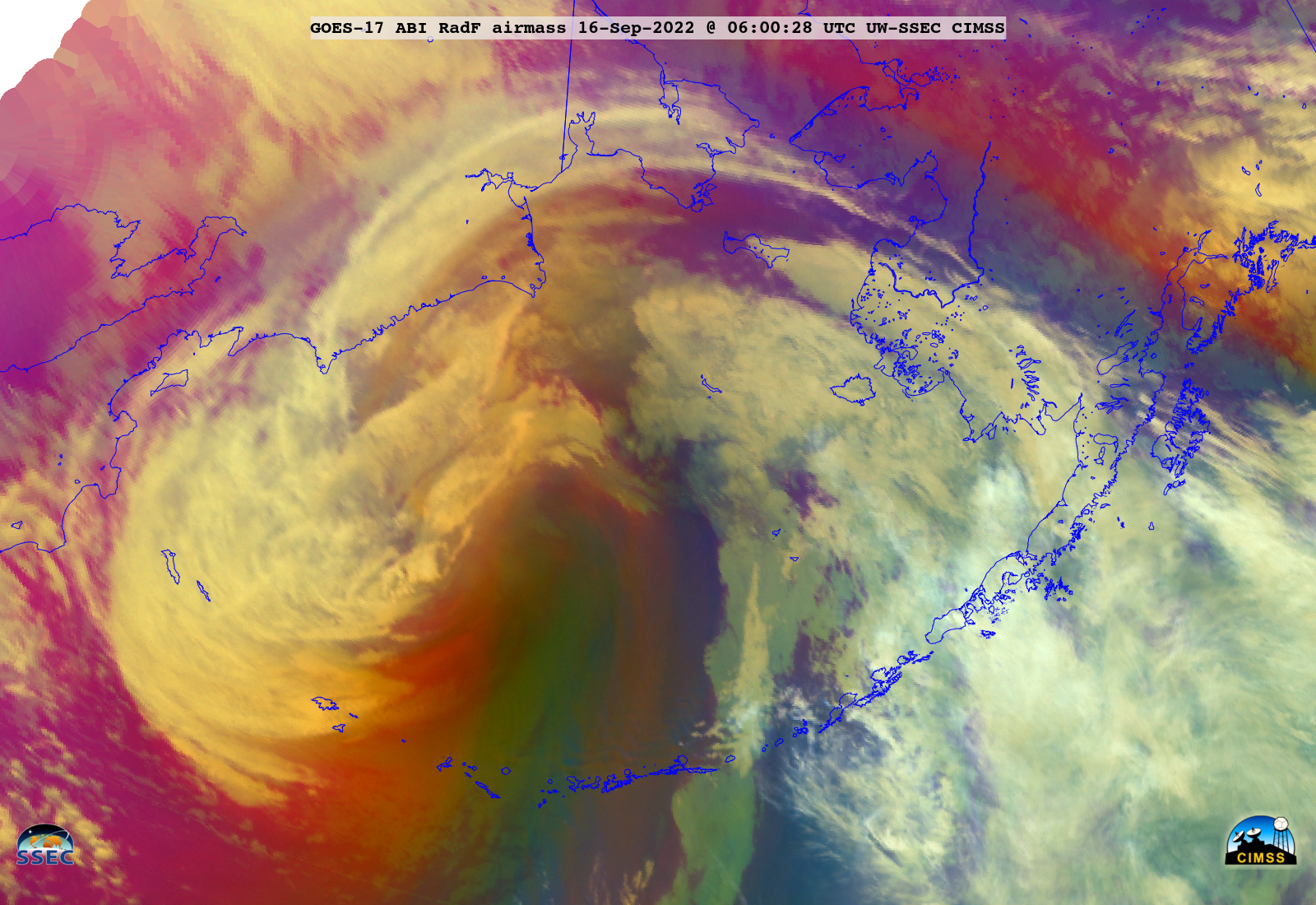
GOES-17_ABI_RadF_airmass_2022259_060028Z.png
2022-09-19 01:04
1.9M
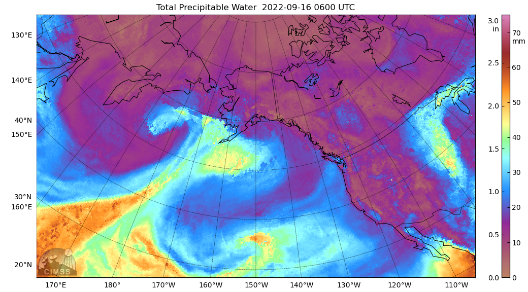
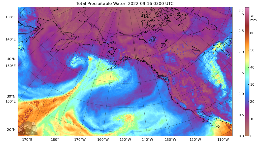
comp20220916.060000_tpw.png
2022-09-19 01:06
640K
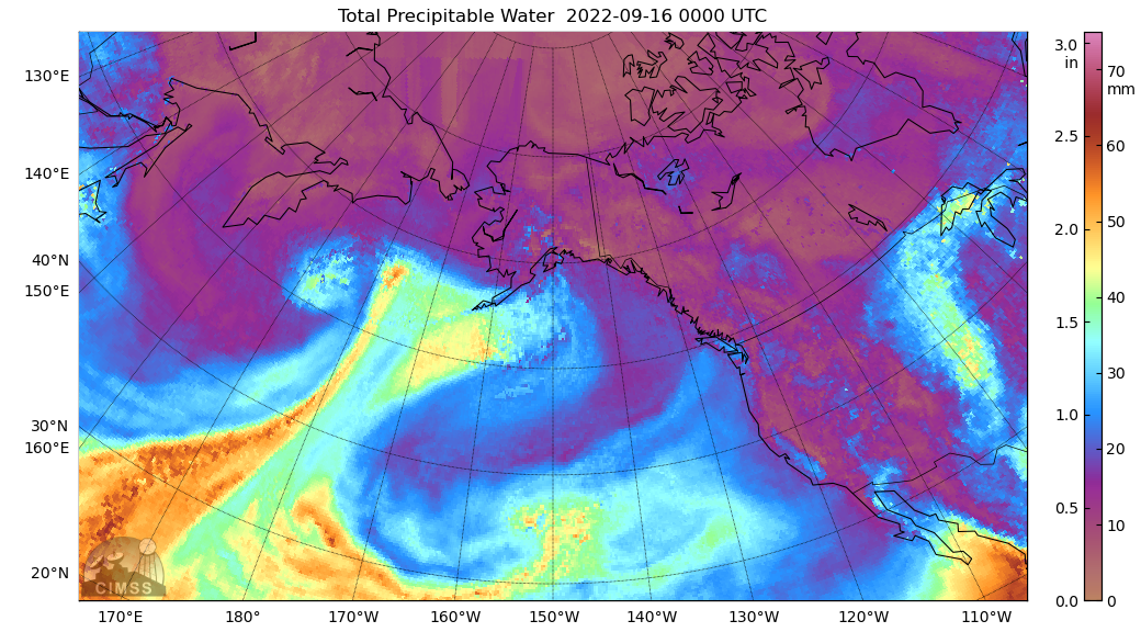
comp20220916.000000_tpw.png
2022-09-19 01:08
647K
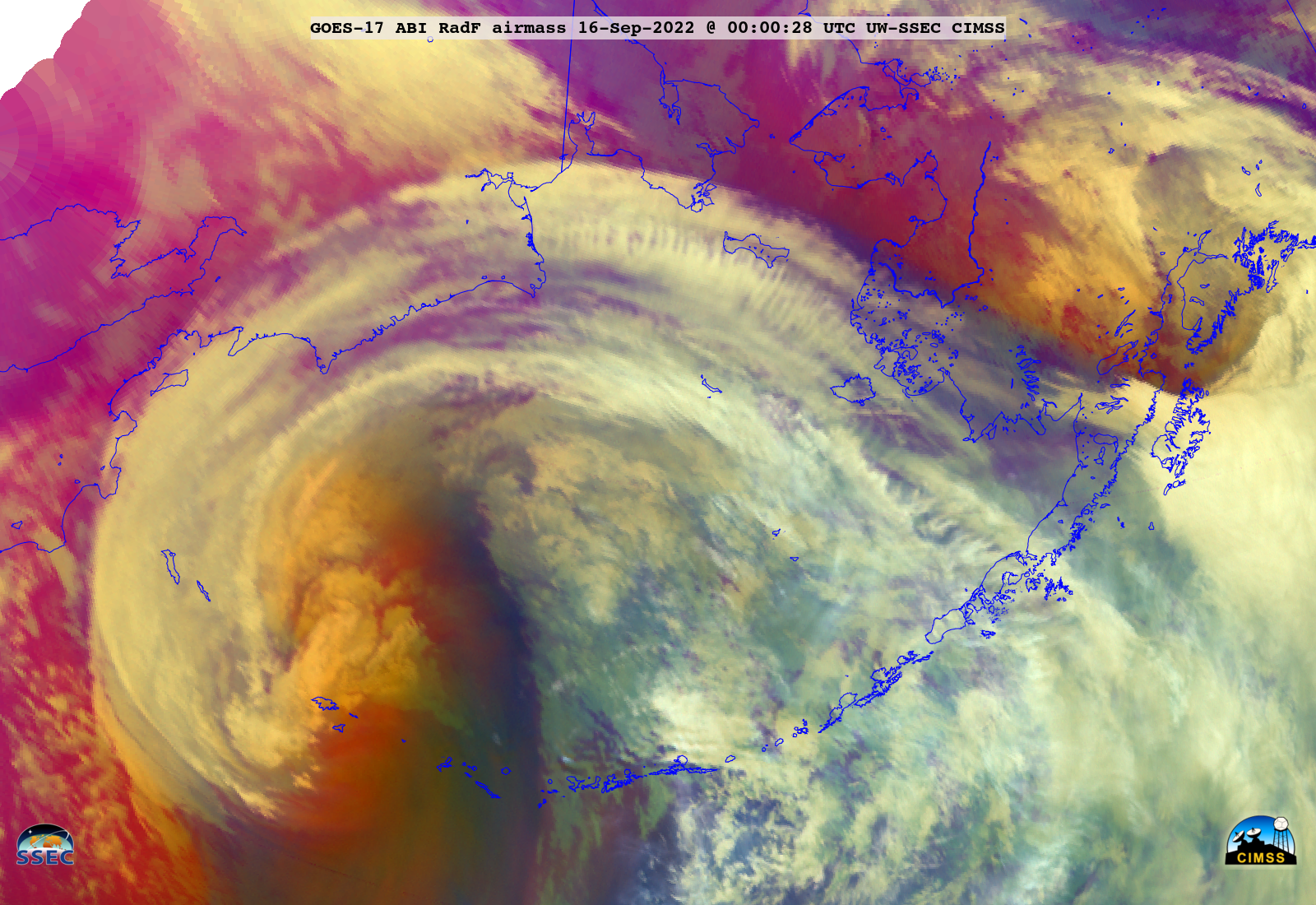
GOES-17_ABI_RadF_airmass_2022259_000028Z.png
2022-09-19 01:10
2.0M
GOES-17_ABI_RadF_airmass_2022259_030028Z.png
2022-09-19 01:10
2.0M
comp20220916.030000_tpw.png
2022-09-19 01:11
646K
220916_06z_sfc.png
2022-09-19 01:53
791K
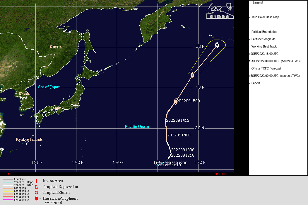
220915_00utc_Merbok_track.gif
2022-09-19 02:32
131K
FD_GOES-8_SANDWICH_MED_BIG_NOMAP_12-Oct-1997_1745_UTC.JPG
2022-09-19 19:07
4.9M
FD_GOES-8_SANDWICH_MED_BIG_NOMAP_14-Oct-1997_1745_UTC.JPG
2022-09-19 19:08
4.8M
220918_42085_water_temperature.png
2022-09-19 19:56
7.7K
220918_42085_wave_height.png
2022-09-19 19:56
6.9K
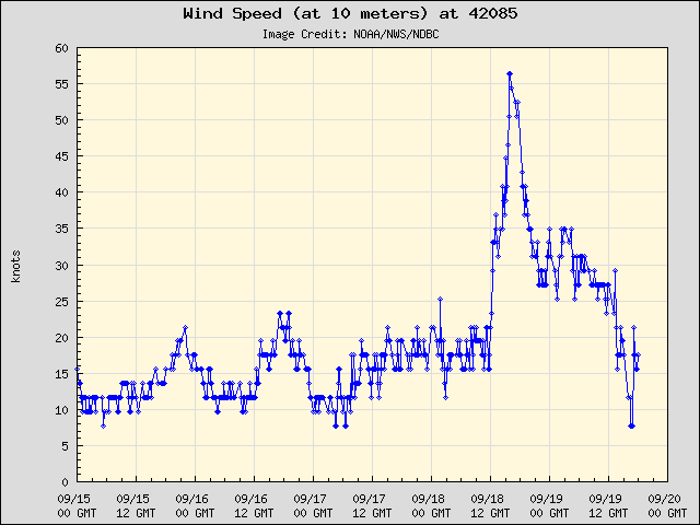
220918_42085_wind_speed_10m.png
2022-09-19 19:56
11K
220918_42085_wind_speed_20m.png
2022-09-19 19:56
11K
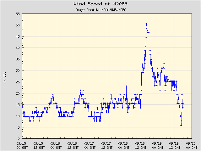
220918_42085_wind_speed.png
2022-09-19 19:56
10K
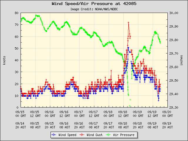
220918_42085_winds_pressure.png
2022-09-19 19:56
20K
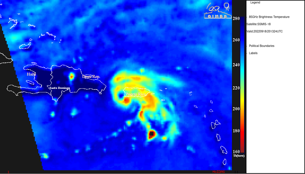
220918_2013utc_dmsp18_ssmis_microwave_Fiona.gif
2022-09-19 19:57
116K
220918_goes16_infrared_17utc_shear_Fiona_anim.gif
2022-09-19 19:57
1.9M
220918_sst_Fiona.gif
2022-09-20 02:07
22K
220920_goes16_visible_WI_IL_bore_anim.gif
2022-09-20 20:41
152M
220920_goes16_visible_WI_IL_bore_anim.mp4
2022-09-20 20:41
14M
fiona_cth-20220921_090027.png
2022-09-22 01:03
113K
fiona_ctt-20220921_090027.png
2022-09-22 01:03
247K
fiona_glm-20220921_090027.png
2022-09-22 01:03
228K
fiona_ir-20220921_090027.png
2022-09-22 01:03
234K
220921_goes16_cloudTopTemperature_cloudTopHeight_Fiona_anim.gif
2022-09-22 01:25
429M
220921_goes16_cloudTopTemperature_cloudTopHeight_Fiona_anim.mp4
2022-09-22 01:25
52M
220921_goes16_infrared_glmFlashExtentDensity_Fiona_anim.gif
2022-09-22 01:25
493M
220921_goes16_infrared_glmFlashExtentDensity_Fiona_anim.mp4
2022-09-22 01:25
51M
220921_goes16_visible_infrared_Fiona_anim.gif
2022-09-22 01:25
329M
220921_goes16_visible_infrared_Fiona_anim.mp4
2022-09-22 01:26
32M
fiona_glm-20220921_132425.png
2022-09-22 01:49
226K
220921_0700utc_suomiNPP_viirs_goes16_abi_infrared_Fiona_anim.gif
2022-09-22 02:55
1.3M
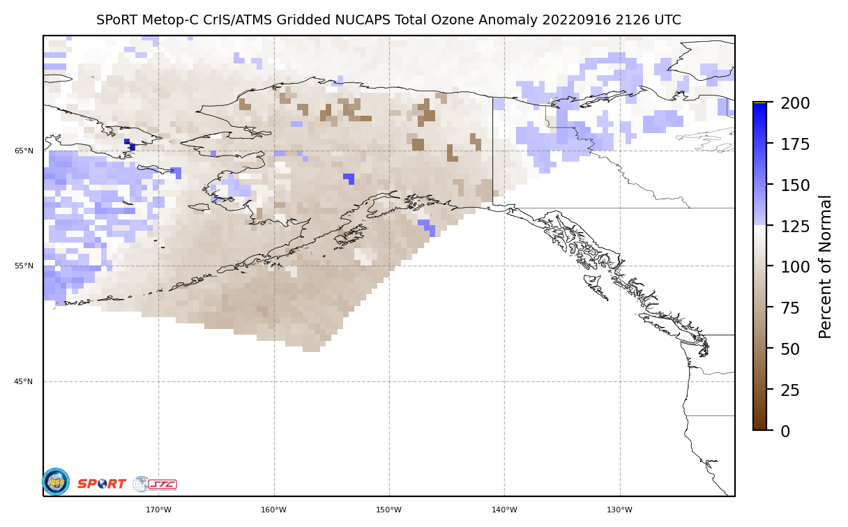
20220916_2126_gridded_nucaps_m03_alaska_web12_OZA.png
2022-09-22 19:44
176K
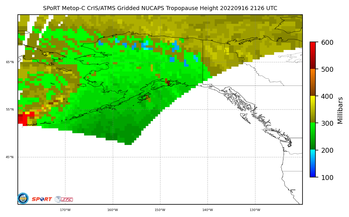
20220916_2126_gridded_nucaps_m03_alaska_web13_TPH.png
2022-09-22 19:44
146K
ak_pv-20220916_213031.png
2022-09-22 19:57
1.7M
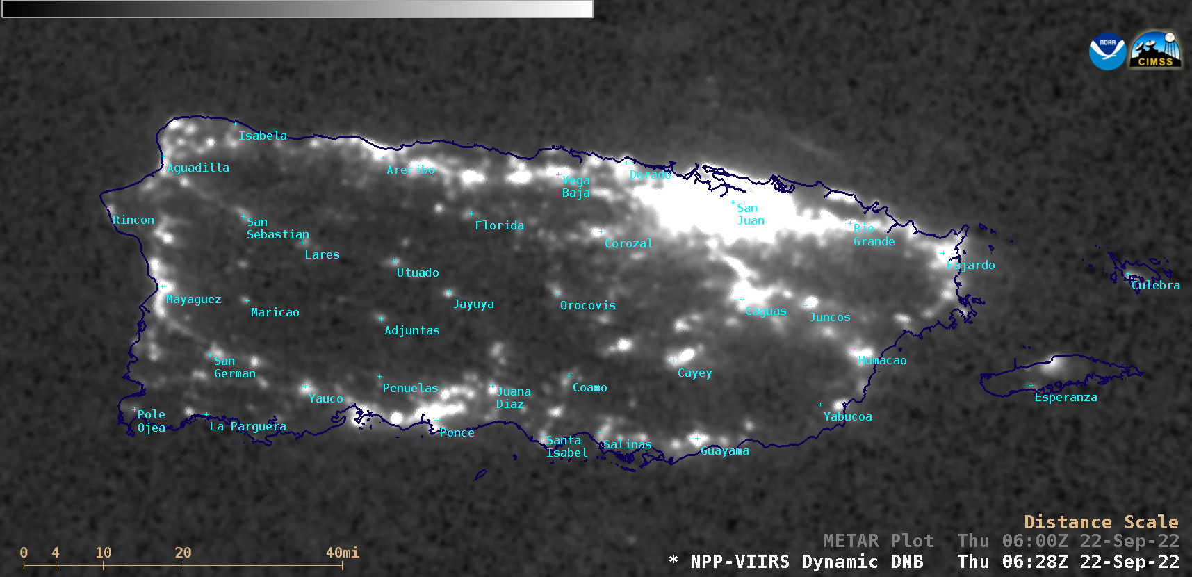
pr_dnb-20220922_062800.png
2022-09-22 21:30
704K
220922_220923_goes16_infrared_Fiona_Bermuda_anim.mp4
2022-09-23 15:17
33M
220922_220923_goes16_infrared_Fiona_Bermuda_anim.gif
2022-09-23 15:29
361M
220922_220923_goes16_infrared_Fiona_Bermuda_small_anim.mp4
2022-09-23 15:29
11M
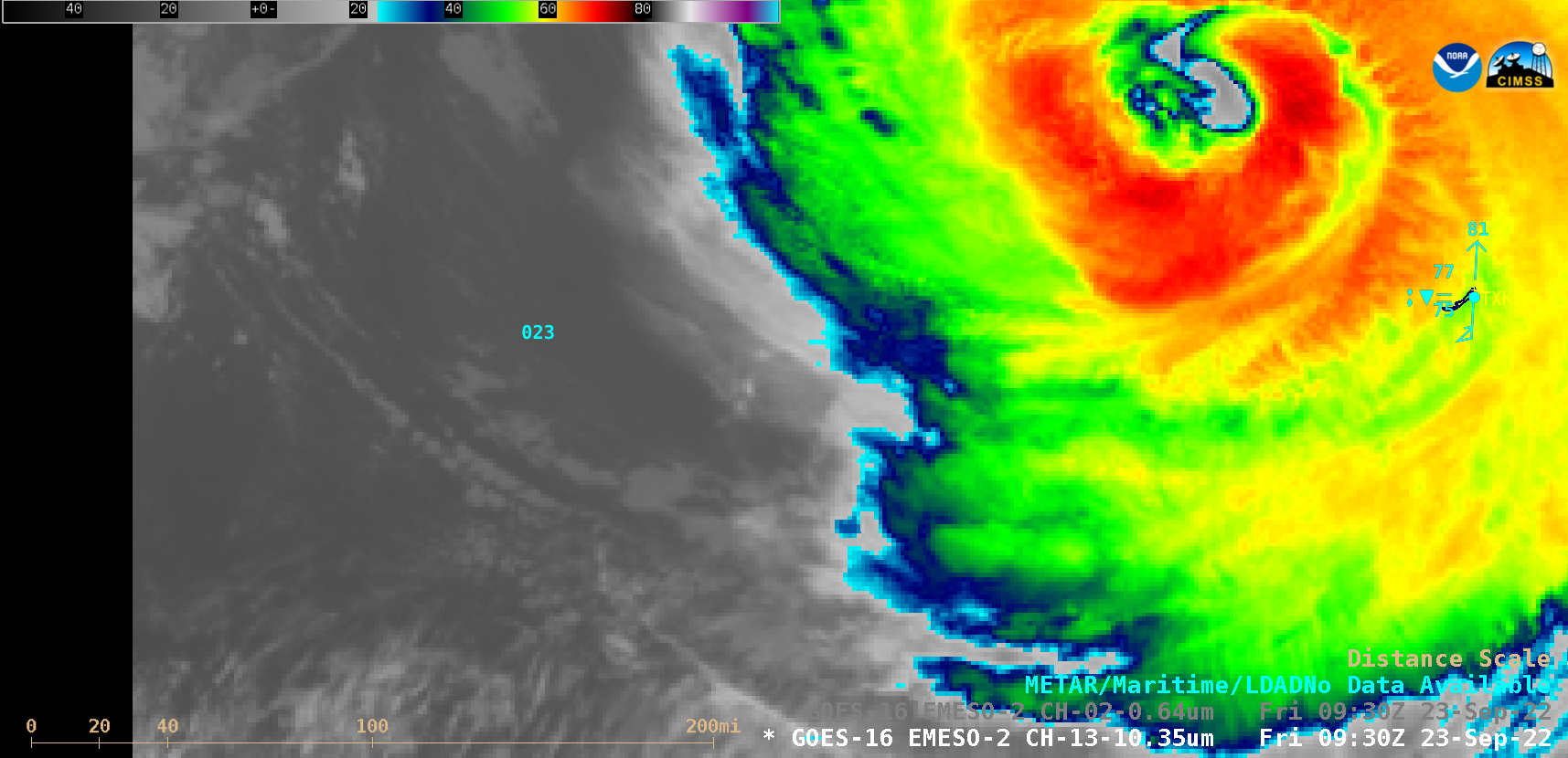
fiona_ir-20220923_093055.png
2022-09-23 15:43
151K
fiona_ir-20220923_100055.png
2022-09-23 15:43
151K
fiona_ir-20220923_095655.png
2022-09-23 15:45
151K
220923_1053utc_dmsp17_ssmis_microwave_Fiona.gif
2022-09-23 16:29
118K
220923_0900utc_Bermuda_discussion.text
2022-09-23 17:42
4.3K
G18_WV_SPAC_LOW_23SEP2022_960x1280_QGOES18R_B0009_2022266_120028_PANEL0001.GIF
2022-09-23 21:28
16K
G18_WV_SPAC_LOW_23SEP2022_B9_2022266_120055_GOES-18_0001PANEL_FRAME00002.GIF
2022-09-23 21:31
304K
220923_1818utc_noa20_viirs_seaSurfaceTemperature_TD9_track.png
2022-09-23 22:38
569K
220923_goes18_waterVapor_South_Pacific_cyclone_anim.gif
2022-09-23 23:35
216M
220923_goes18_waterVapor_South_Pacific_cyclone_anim.mp4
2022-09-23 23:35
18M
220923_goes18_waterVapor_South_Pacific_cyclone_small_anim.mp4
2022-09-23 23:35
11M
G18_VIS_SPAC_LOW_23SEP2022_B2_2022266_153125_GOES-18_0001PANEL_FRAME00001.GIF
2022-09-24 02:01
336K
G18_WV_SPAC_LOW_23SEP2022_B9_2022266_175825_GOES-18_0001PANEL_FRAME00717.GIF
2022-09-24 02:04
292K
220923_goes16_waterVapor_Fiona_anim.gif
2022-09-24 03:32
166M
220923_goes16_waterVapor_Fiona_anim.mp4
2022-09-24 03:32
10M
220923_220924_goes16_waterVapor_Fiona_landfall_NS_small_anim.mp4
2022-09-24 16:31
17M
fiona_wv2-20220924_080055.png
2022-09-24 17:14
353K
animgif_framenumber_000600.png
2022-09-24 17:17
935K
fiona_wv2-20220924_060055.png
2022-09-24 17:17
365K
g16_wv-20220924_103155.png
2022-09-24 23:51
322K
g16_wv_v2-20220924_103155.png
2022-09-24 23:51
322K
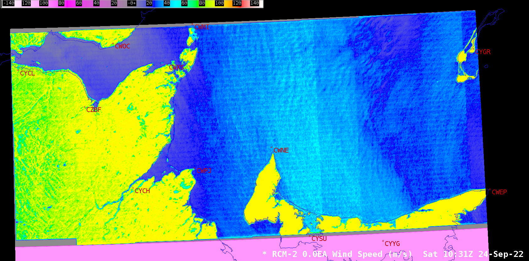
rcm2-20220924_103132.png
2022-09-25 01:42
639K
rcm2_v2-20220924_103132.png
2022-09-25 01:42
565K
fiona_wv2-20220924_101555.png
2022-09-25 01:49
366K
fiona_wv2-20220924_110155.png
2022-09-25 01:49
375K
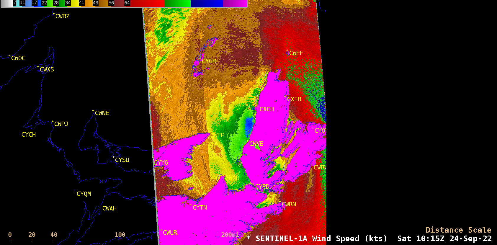
s1a-20220924_101522.png
2022-09-25 01:49
439K
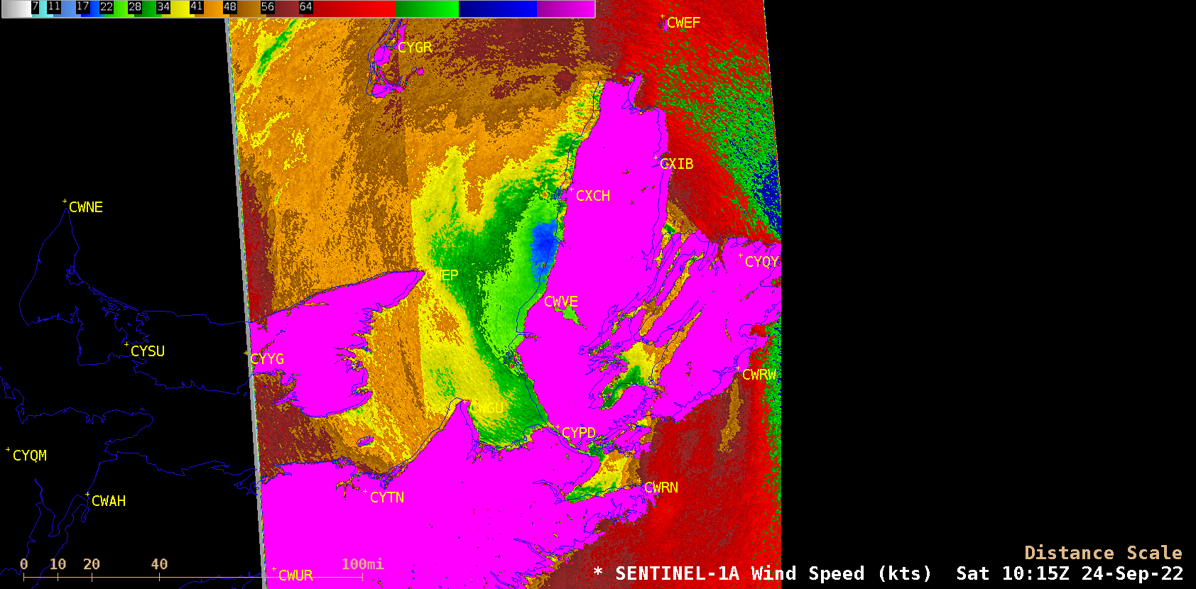
s1a_enh1-20220924_101522.png
2022-09-25 01:49
492K
s1a_enh2-20220924_101522.png
2022-09-25 01:49
494K
s1a_enh3-20220924_101522.png
2022-09-25 02:31
660K
fiona_wv2-20220924_070055.png
2022-09-25 02:38
348K
fiona_wv2_topo-20220924_070055.png
2022-09-25 02:38
158K
fiona_wv2_topo_compare-20220924_070055.png
2022-09-25 02:38
235K
220924_0700utc_goes16_waterVapor_topography_anim.gif
2022-09-25 02:45
629K
s1a_sar_fiona-20220924_101522.png
2022-09-26 14:53
1.0M
220924_meanSeaLevelPressure_anomaly_Fiona_landfall_anim.gif
2022-09-26 14:54
1.3M
220924_surface_analyses_Fiona_landfall_anim.gif
2022-09-26 14:55
4.0M
220923_220924_goes16_waterVapor_Fiona_landfall_NS_anim.gif
2022-09-26 15:23
542M
220923_220924_goes16_waterVapor_Fiona_landfall_NS_anim.mp4
2022-09-26 15:23
29M
220925_Fiona_storm_summary.text
2022-09-26 15:55
6.0K
220923_500hPaGeopotentialHeightAnomaly_South_Pacific_low_anim.gif
2022-09-26 18:48
490K
220923_meanSeaLevelPressureAnomaly_South_Pacific_low_anim.gif
2022-09-26 18:48
557K
220923_goes18_visible_South_Pacific_cyclone_anim.gif
2022-09-26 20:54
156M
220923_goes18_visible_South_Pacific_cyclone_anim.mp4
2022-09-26 20:54
13M
G18_VIS_SPAC_LOW_23SEP2022_B2_2022266_180455_GOES-18_0001PANEL_FRAME00308.GIF
2022-09-26 20:57
601K
220926_goes16_visible_exFiona_anim.gif
2022-09-26 22:16
35M
220926_goes16_visible_exFiona_anim.mp4
2022-09-26 22:16
6.8M
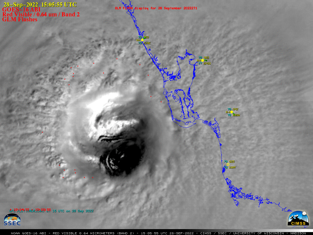
ian_glm-20220926_210055.png
2022-09-27 17:35
594K
ian_ir-20220926_210055.png
2022-09-27 17:35
502K
ian_vis-20220926_210055.png
2022-09-27 17:35
603K
ian_vis-20220927_170055.png
2022-09-27 18:49
829K
220926_goes16_visible_30second_Ian_anim.gif
2022-09-27 18:59
206M
220926_goes16_visible_30second_Ian_anim.mp4
2022-09-27 18:59
5.6M
ian_glm-20220927_171225.png
2022-09-28 00:14
616K
ian_glm-20220927_171255.png
2022-09-28 00:14
616K
ian_ir-20220927_171225.png
2022-09-28 00:14
455K
ian_ir-20220927_171255.png
2022-09-28 00:14
456K
ian_vis-20220927_171225.png
2022-09-28 00:14
624K
ian_vis-20220927_171255.png
2022-09-28 00:14
624K
220927_2219utc_dmsp16_ssmis_microwave_Ian.gif
2022-09-28 00:34
30K
220927_adt_Ian.gif
2022-09-28 00:34
12K
220927_goes16_infrared_21utc_shear_Ian_anim.gif
2022-09-28 00:34
1.9M
220927_ohc_Ian.gif
2022-09-28 00:34
30K
220927_satcon_Ian.png
2022-09-28 00:34
404K
220927_sst_Ian.gif
2022-09-28 00:34
30K
220927_1947utc_noaa20_infrared_visible_Ian_anim.gif
2022-09-28 03:41
908K
220927_goes16_infrared_Ian_anim.gif
2022-09-28 03:41
524M
220927_goes16_infrared_Ian_anim.mp4
2022-09-28 03:41
28M
220927_goes16_infrared_Ian_small_anim.mp4
2022-09-28 03:41
15M
220927_goes16_visible_glmFlashExtentDensity_Ian_anim.gif
2022-09-28 03:41
564M
220927_goes16_visible_glmFlashExtentDensity_Ian_anim.mp4
2022-09-28 03:41
11M
ian_ir-20220928_190055.png
2022-09-28 19:29
362K
ian_vis-20220928_190055.png
2022-09-28 19:29
585K
ian_ir-20220928_190555.png
2022-09-28 19:45
363K
ian_vis-20220928_190555.png
2022-09-28 19:45
584K
ian_ir-20220928_200055.png
2022-09-28 21:21
384K
ian_vis-20220928_200055.png
2022-09-28 21:21
622K
220928_goes16_infared_visible_Hurricane_Ian_landfall_anim.gif
2022-09-29 01:51
860M
220928_goes16_infared_visible_Hurricane_Ian_landfall_anim.mp4
2022-09-29 01:51
37M
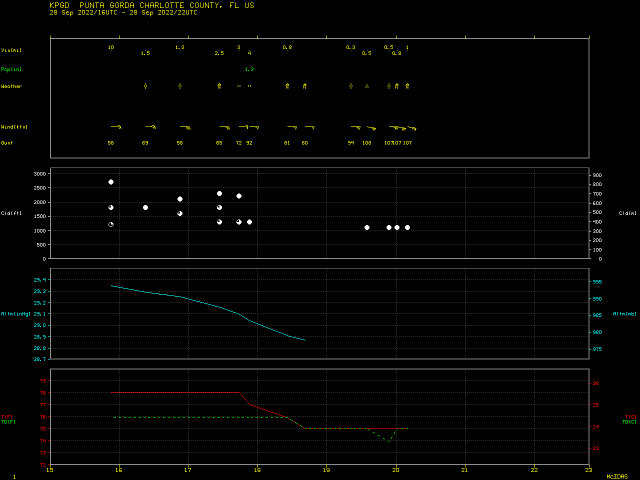
220928_KPGD_SFCMG.GIF
2022-09-29 01:57
15K
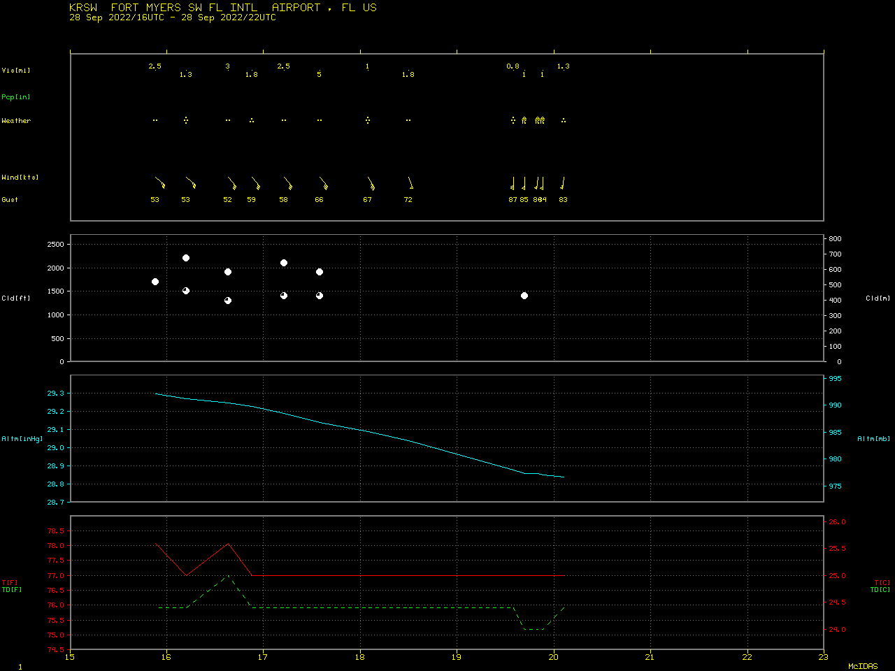
220928_KRSW_SFCMG.GIF
2022-09-29 01:57
16K
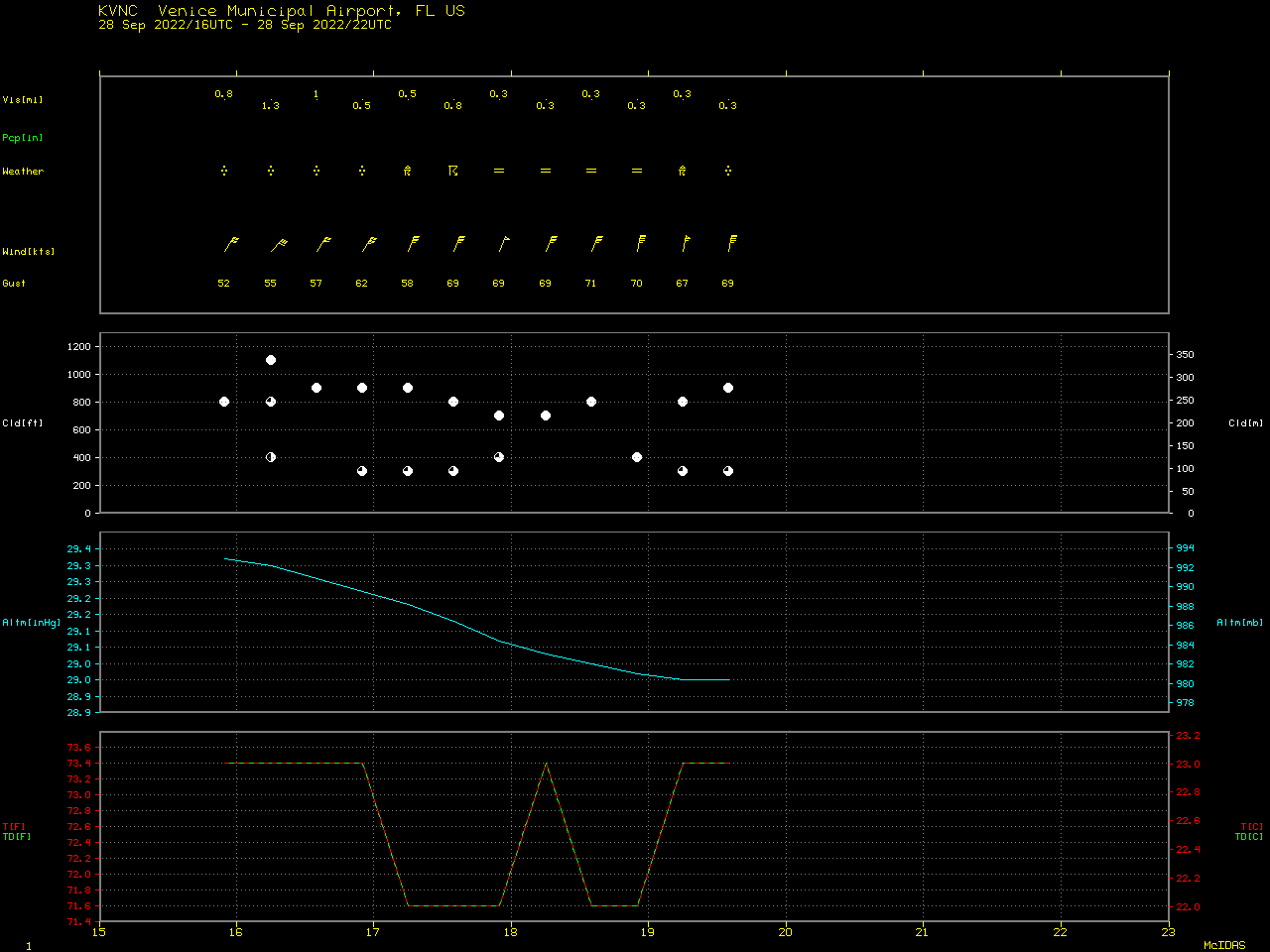
220928_KVNC_SFCMG.GIF
2022-09-29 01:57
17K
220928_ktbw_pns_wind.text
2022-09-29 02:26
9.9K
220928_ktbw_pns_rainfall.text
2022-09-29 02:28
3.5K
220928_1049utc_dmsp16_ssmis_microwave_Ian.gif
2022-09-29 03:45
144K
220928_2244utc_power_outages_FL.png
2022-09-29 03:45
78K
220928_adt_Ian.gif
2022-09-29 03:45
13K
220928_goes16_infrared_22utc_shear.gif
2022-09-29 03:45
2.0M
220928_goes16_infrared_shear.gif
2022-09-29 03:45
1.7M
220928_goes16_visible_17utc_shear.gif
2022-09-29 03:45
2.2M
220928_satcon_Ian.png
2022-09-29 03:45
439K
220928_sst_Ian.gif
2022-09-29 03:45
90K
220928_sst_Ian.png
2022-09-29 03:45
131K
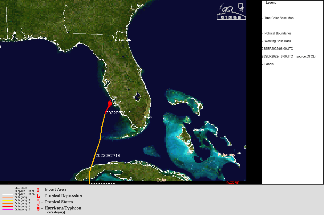
220928_track_Ian.gif
2022-09-29 03:45
90K
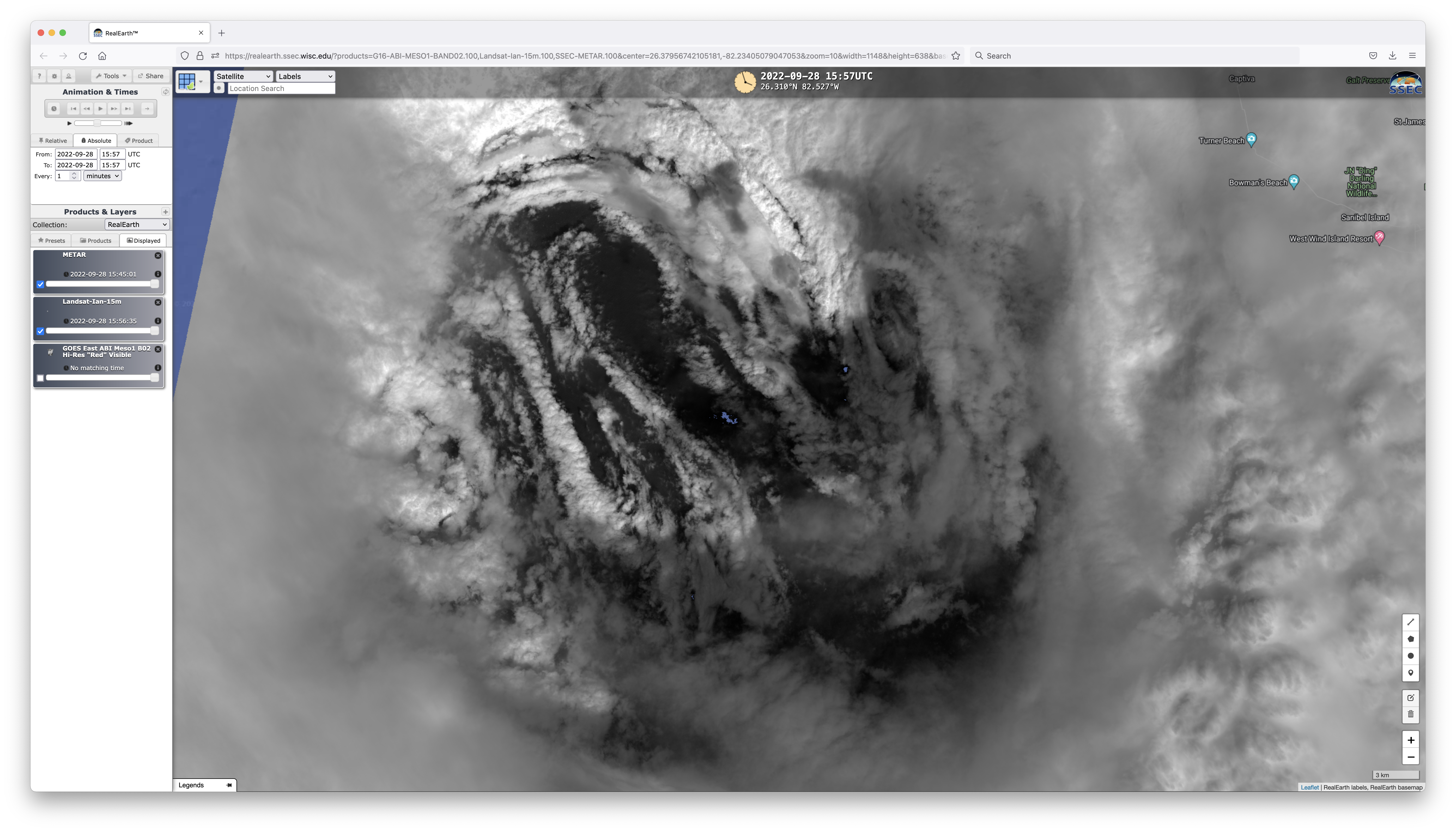
220928_1556utc_goes16_visible_landsat8_falseColorRGB_Hurricane_Ian_eye_anim.gif
2022-09-29 18:50
1.9M
220929_wpc_storm_summary.text
2022-09-29 19:50
4.5K
2022_09_27-29_ian_color_visible.mp4
2022-09-29 21:00
192M
2022_09_28_ian_ircm_30s.mp4
2022-09-29 21:00
72M
G16_VIS_GLM_IAN_EYE_LANDFALL_28SEP2022_B2_2022271_150028_GOES-16_0001PANEL_FRAME00001.GIF
2022-09-30 00:36
257K
G16_VIS_GLM_IAN_EYE_LANDFALL_28SEP2022_B2_2022271_190555_GOES-16_0001PANEL_FRAME00492.GIF
2022-09-30 02:00
254K
G16_VIS_GLM_IAN_EYE_LANDFALL_28SEP2022_B2_2022271_151055_GOES-16_0001PANEL_FRAME00022.GIF
2022-09-30 02:16
267K
220928_1556utc_goes16_visible_labels.png
2022-09-30 02:42
562K
220928_1556utc_goes16_visible_map.png
2022-09-30 02:42
462K
220928_1556utc_landsat8_falseColorRGB_labels.png
2022-09-30 02:42
1.3M
220928_1556utc_landsat8_falseColorRGB_map.png
2022-09-30 02:42
1.2M
220928_1556utc_landsat8_falseColorRGB.png
2022-09-30 02:42
1.2M
220928_1557utc_goes16_visible_labels.png
2022-09-30 02:47
575K
220928_1557utc_goes16_visible_map.png
2022-09-30 02:47
459K
220928_1557utc_landsat8_falseColorRGB_Hurricane_Ian_eye_anim.gif
2022-09-30 02:47
1.1M
220928_1557utc_landsat8_falseColorRGB_labels_Ian.png
2022-09-30 02:48
1.3M
220928_1557utc_landsat8_falseColorRGB_outlines_Ian.png
2022-09-30 02:48
1.2M
220928_1557utc_landsat8_visible_labels.png
2022-09-30 02:48
1.0M
220928_1557utc_landsat8_visible_map.png
2022-09-30 02:48
907K
220928_1557utc_landsat8_goes16_visible_Hurricane_Ian_eye_anim.gif
2022-09-30 02:52
1.6M
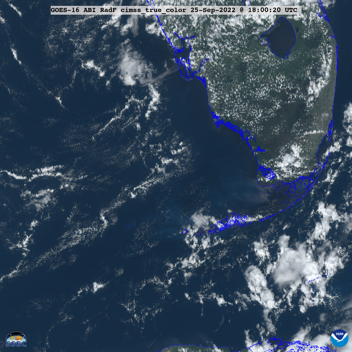
Sedi_GOES-16_ABI_RadF_cimss_true_color_2022273_180020Z.png
2022-09-30 19:47
2.5M
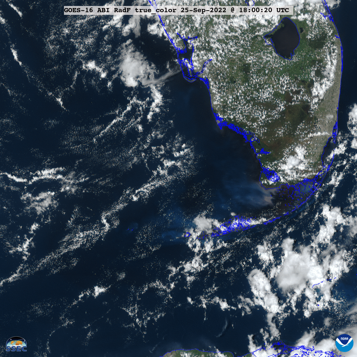
Sedi_GOES-16_ABI_RadF_true_color_2022273_180020Z.png
2022-09-30 19:48
2.7M
Sedi_GOES-16_ABI_RadF_cimss_true_color_2022268_180020Z.png
2022-09-30 19:48
2.4M
Sedi_GOES-16_ABI_RadF_true_color_2022268_180020Z.png
2022-09-30 19:49
2.7M
Sedi_GOES-16_ABI_RadF_cimss_true_color_2022268_2022273_180020Z.gif
2022-09-30 19:55
2.3M
Sedi_GOES-16_ABI_RadF_true_color_2022268_2022273_180020Z.gif
2022-09-30 19:56
2.5M
G16_VIS_GLM_IAN_EYE_LANDFALL_28SEP2022_B2_2022271_150555_GOES-16_0001PANEL_FRAME00012.GIF
2022-10-01 15:21
401K
220928_1557utc_landsat8_zoom_labels.png
2022-10-01 19:18
6.2M
220928_1557utc_landsat8_zoom_map.png
2022-10-01 19:18
6.2M
220928_1557utc_landsat8_visible_zoom_anim.gif
2022-10-01 19:23
5.1M
220928_goes16_visible_glmFlashes_Ian_landfall_anim.gif
2022-10-02 16:52
210M
220928_goes16_visible_glmFlashes_Ian_landfall_anim.mp4
2022-10-02 16:52
38M
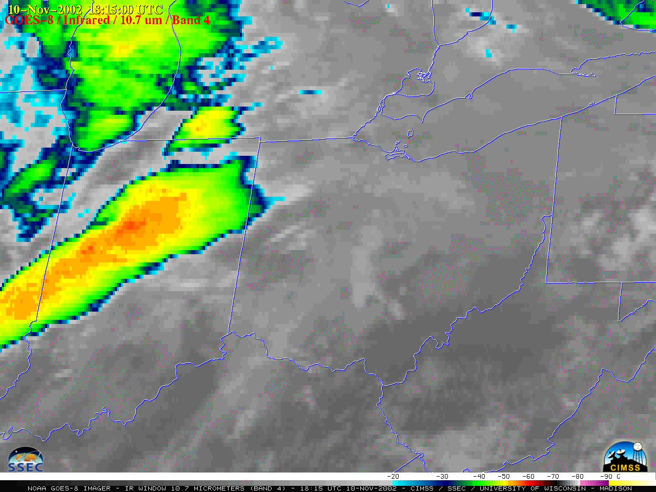
G08_IR_IN_OH_PA_SVR_10NOV2002_B4_2002314_204500_GOES-8_0001PANEL_FRAME00001.GIF
2022-10-02 17:18
229K
G08_WV_IN_OH_PA_SVR_10NOV2002_B3_2002314_204500_GOES-8_0001PANEL_FRAME00001.GIF
2022-10-02 17:31
178K
021110_goes8_waterVapor_IN_OH_PA_anim.gif
2022-10-03 02:01
13M
021110_goes8_waterVapor_IN_OH_PA_anim.mp4
2022-10-03 02:01
2.8M
021110_goes8_infrared_IN_OH_PA_anim.gif
2022-10-03 02:24
16M
021110_goes8_infrared_IN_OH_PA_anim.mp4
2022-10-03 02:24
5.6M
220930_goes16_dayCloudPhaseDistinctionRGB_Ian_SC_landfall_anim.gif
2022-10-03 23:45
338M
220930_goes16_dayCloudPhaseDistinctionRGB_Ian_SC_landfall_anim.mp4
2022-10-03 23:45
37M
220930_goes16_infrared_Ian_SC_landfall_anim.gif
2022-10-03 23:45
219M
220930_goes16_infrared_Ian_SC_landfall_anim.mp4
2022-10-03 23:45
19M
220930_goes16_visible_Ian_SC_landfall_anim.gif
2022-10-03 23:45
197M
220930_goes16_visible_Ian_SC_landfall_anim.mp4
2022-10-03 23:45
20M
ian_ir-20220930_180555.png
2022-10-04 00:09
256K
ian_rgb-20220930_180555.png
2022-10-04 00:09
852K
ian_vis-20220930_180555.png
2022-10-04 00:09
660K
220930_buoy41004_winds_pressure.png
2022-10-04 00:58
21K
220930_buoy41024_winds_pressure.png
2022-10-04 00:58
20K
220930_buoy41029_winds_pressure.png
2022-10-04 00:58
16K
220930_ian_track.png
2022-10-04 00:58
598K
ian_ir-20220930_150055.png
2022-10-04 01:42
201K
ian_rgb-20220930_150055.png
2022-10-04 01:42
353K
ian_vis-20220930_150055.png
2022-10-04 01:42
310K
ian_ir-20220930_145955.png
2022-10-04 01:47
292K
ian_rgb-20220930_145955.png
2022-10-04 01:47
831K
ian_vis-20220930_145955.png
2022-10-04 01:47
655K
220930_kchs_kilm_Ian_wind_gusts_pns.text
2022-10-05 01:32
8.4K
220930_kchs_kilm_Ian_rainfall_pns.text
2022-10-05 01:44
8.6K
221003_buoy41004_water_temperature_post_Ian.png
2022-10-05 02:12
7.6K
221003_buoy41004_wave_height_post_Ian.png
2022-10-05 03:05
7.2K
5x4_ian_landfall.png
2022-10-05 16:56
30M
5x4_ian_landfall_update.png
2022-10-20 15:02
29M
50pct_5x4_ian_landfall_update.png
2022-10-20 15:35
8.2M
25pct_5x4_ian_landfall_update.png
2022-10-20 15:36
2.2M
50pct_5x4_ian_landfall_update_logos.png
2022-10-20 15:43
8.2M
50pct_5x4_ian_landfall_update_logos.jpg
2022-10-20 15:43
2.6M
1000x1000_01_GOES-16_ABI_RadF_C02_2022271_180020Z.tif
2022-12-23 17:17
302K
1000x1000_03_GOES-16_ABI_RadF_C03_2022271_180020Z.tif
2022-12-23 17:17
447K
1000x1000_04_GOES-16_ABI_RadF_C04_2022271_180020Z.tif
2022-12-23 17:17
347K
1000x1000_05_GOES-16_ABI_RadF_C05_2022271_180020Z.tif
2022-12-23 17:17
691K
1000x1000_06_GOES-16_ABI_RadF_C07_2022271_180020Z.tif
2022-12-23 17:17
791K
1000x1000_07_GOES-16_ABI_RadF_C13_2022271_180020Z.tif
2022-12-23 17:17
833K
1000x1000_08_GOES-16_ABI_RadF_C16_2022271_180020Z.tif
2022-12-23 17:17
708K
1000x1000_09_GOES-16_ABI_RadF_C10_2022271_180020Z.tif
2022-12-23 17:17
736K
1000x1000_11_GOES-16_ABI_RadF_convection_2022271_180020Z.tif
2022-12-23 17:17
2.3M
1000x1000_12_GOES-16_ABI_RadF_day_microphysics_2022271_180020Z.tif
2022-12-23 17:17
2.4M
1000x1000_13_GOES-16_ABI_RadF_day_snow_fog_2022271_180020Z.tif
2022-12-23 17:17
2.7M
1000x1000_15_GOES-16_ABI_RadF_fire_temperature_abi_2022271_180020Z.tif
2022-12-23 17:17
2.0M
1000x1000_16_GOES-16_ABI_RadF_natural_color_2022271_180020Z.tif
2022-12-23 17:17
3.3M
1000x1000_17_GOES-16_ABI_RadF_plume_night_2022271_180020Z.tif
2022-12-23 17:17
2.3M
1000x1000_18_GOES-16_ABI_RadF_so2_2022271_180020Z.tif
2022-12-23 17:17
2.0M
1000x1000_19_GOES-16_ABI_RadF_cloud_phase_distinction_2022271_180020Z.tif
2022-12-23 17:17
2.6M
1000x1000_21_GOES-16_ABI_RadF_true_color_2022271_180020Z.tif
2022-12-23 17:17
2.0M
1000x1000_22_GOES-16_ABI_RadF_airmass_2022271_180020Z.tif
2022-12-23 17:17
1.7M
1000x1000_23_GOES-16_ABI_RadF_dust_2022271_180020Z.tif
2022-12-23 17:17
2.0M
1000x1000_24_GOES-16_ABI_RadF_cimss_true_color_2022271_180020Z.tif
2022-12-23 17:17
1.7M
3x4_ian_landfall_no_labels.png
2022-12-23 17:59
18M
50pct_3x4_ian_landfall_no_labels.png
2022-12-23 17:59
4.7M
Ian_12_no_labels_2022172_18Z.txt
2022-12-23 18:50
119
GOES-16_ABI_RadF_true_color_2022253_170020Z.tif.jpg
2023-07-27 20:30
50M
1024x1024_GOES-16_ABI_RadF_true_color_2022253_170020Z.tif.jpg
2023-07-27 20:30
446K
Ian_GOES-16_ABI_RadF_C07_2022271_180020Z.tif
2024-01-22 19:11
15M
Ian_GOES-16_ABI_RadF_C13_2022271_180020Z.tif
2024-01-22 19:11
15M
Ian_GOES-16_ABI_RadF_C16_2022271_180020Z.tif
2024-01-22 19:11
12M
Ian_GOES-16_ABI_RadF_C10_2022271_180020Z.tif
2024-01-22 19:12
11M
Ian_GOES-16_ABI_RadF_convection_2022271_180020Z.tif
2024-01-22 19:16
61M
Ian_GOES-16_ABI_RadF_day_microphysics_2022271_180020Z.tif
2024-01-22 19:18
68M
Ian_GOES-16_ABI_RadF_day_snow_fog_2022271_180020Z.tif
2024-01-22 19:19
71M
Ian_GOES-16_ABI_RadF_natural_color_2022271_180020Z.tif
2024-01-22 19:25
280M
Ian_GOES-16_ABI_RadF_so2_2022271_180020Z.tif
2024-01-22 19:26
47M
Ian_GOES-16_ABI_RadF_cloud_phase_distinction_2022271_180020Z.tif
2024-01-22 19:27
57M
Ian_GOES-16_ABI_RadF_true_color_2022271_180020Z.tif
2024-01-22 19:50
272M
Ian_GOES-16_ABI_RadF_airmass_2022271_180020Z.tif
2024-01-22 19:51
57M
Ian_GOES-16_ABI_RadF_dust_2022271_180020Z.tif
2024-01-22 19:51
57M
Ian_GOES-16_ABI_RadF_cimss_true_color_2022271_180020Z.tif
2024-01-22 19:53
245M