This website works best with a newer web browser such as Chrome, Firefox, Safari or Microsoft Edge. Internet Explorer is not supported by this website.

Stories by Scott Lindstrom

Moist air over the tropical western Pacific Ocean

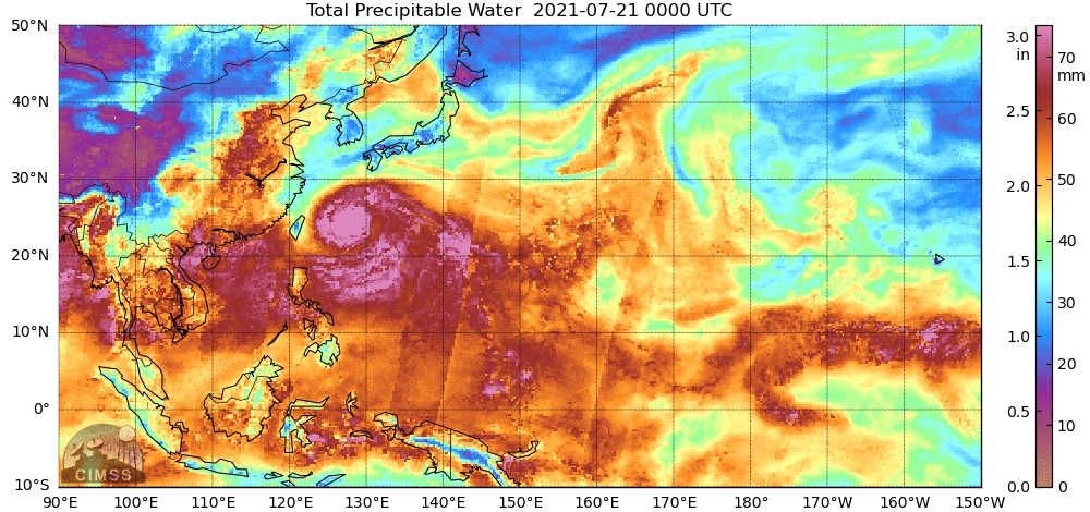
Microwave estimates of total precipitable water over the western Pacific Ocean (available here) show a moist airmass — out of which Typhoon In-Fa (seen near Taiwan in the animation) emerged — over the western Pacific Ocean. (The circulation of Tropical cyclone Cempaka is also apparent near the Gulf of Tonkin)... Read More

Aerosol Optical Depth and surface visibility

The image above shows the Level 2 GOES-R product, Aerosol Optical Depth (AOD), a product created in clear skies, overlain with the GOES-16 Visible imagery from the same time. AOD measures the extinction of light via scattering and absorption by small particles in the atmosphere, and it can be used... Read More

Creating RGB imagery using SIFT and Geo2Grid

The use of routine multispectral geostationary satellite imagery over the United States has increased the routine use of Red/Green/Blue composite imagery to describe and evaluate surface and atmospheric conditions. This blog post will detail how to create new (or old) RGB composites using two UW-Madison/CIMSS/SSEC-developed tools: The Satellite Information and... Read More