5.15 micrometer data on GeoXO as revealed by model output
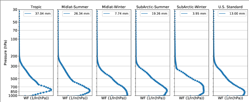
The GXI (GeoXO Imager) instrument to be flown on the GeoXO (Geostationary eXtended Observations) satellite, scheduled for launch in the mid-2030s, is intended to replace ABI data from the current set of GOES-R Satellites. One of the novel channels to be added to GXI senses infrared information at 5.15 µm, a wavelength at which absorption by water vapor occurs. As the weighting functions below show (source: this paper by Milller et al.), the wavelength is sensing information from far down in the atmosphere (in clear skies), much closer to the surface than the current water vapor infrared channels (bands 8-10, 6.19 µm, 6.95 µm and 7.34 µm) on the ABI (as shown here for a mid-latitude Summer atmosphere).

The animation below show simulated 5.15 µm and 7.3 µm imagery for a case in 2019. These 5.15 µm and 7.34 µm imagery are simulated using the Pressure layer Fast Algorithm for Atmospheric Transmittances (PFAAST) model applied to a 1-km ECMWF nature run (XNR1K). The spatial resolution is 2 km and imagery is courtesy of Zhenglong Li. Pay especial attention to the gradients in the low-level field (5.15 µm) at around 1215 UTC over the Gulf of Mexico and around 1545 UTC over the lower Mississippi River — regions highlighted by boxes. Note how such features are absent in the 7.3 µm, the water vapor channel on the ABI that senses infrared information from lowest down in the atmosphere. Convection subsequently develops within those boxes along these gradients that are apparent at 5.15 µm before they are at 7.34 µm. A conclusion might be: data from GXI will likely allow a forecaster to determine earlier where convection might subsequently develop.


