Using GOES-16 to view clouds over snow
GOES-16 data posted on this page are preliminary, non-operational data and are undergoing testing.
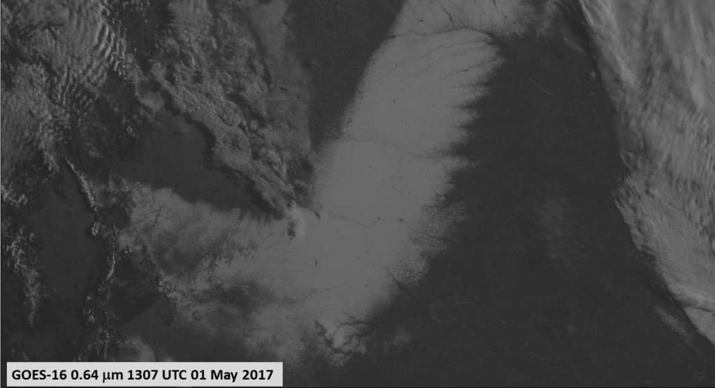
A late-season snow storm dropped a band of heavy snow over Colorado, western Kansas and western Nebraska on 29-30 April 2017. In the visible image above from sunrise on 1 May 2017, it is difficult to guess where the cloud features sit on top of the snow (Click here for a visible image with a map), even with the knowledge that they are casting shadows in this early morning imagery. GOES-16 includes a 1.61 µm channel, however; radiation at that wavelength is absorbed strongly by ice — either in the form of cirrus clouds, or snow, so that reflectance is small over ice features. The toggle below between the 1.61 µm “Snow/Ice” Channel and the 0.64 µm “Red Visible” channel shows ice and snow as dark. Clouds that are made up of water droplets are highly reflective in the 1.61 µm and in the 0.64 µm channels; such water clouds (there are only a few of them!) show up as very bright against the dark background of snow in the 1.61 µm channel.
Note in the toggle above that shadows are much darker in the 1.61 µm channel. Why?
Atmospheric scattering is stronger at shorter wavelengths in the atmosphere; there is more scattering of 0.64 µm radiation than of 1.61 µm radiation. In the shadow regions, more 0.64 µm radiation than 1.61 µm is being scattered back towards the satellite for detection. Shadows in the 0.47 µm “Blue Visible” band should be even less distinct. Non-annotated versions of imagery are available here for 0.64 µm and here for 1.61 µm.
During the subsequent late morning and early afternoon hours, the edges of the long swath of snow cover were seen to melt quickly — due to heating from the high May sun angle — on GOES-16 Visible (0.64 µm) and Snow/Ice (1.61 µm) images, below. The Snow/Ice images helped to highlight bright cumulus clouds (composed of supercooled water droplets) drifting southeastward across the snow cover.
Animations of GOES-16 Visible vs Snow/Ice images from the previous day (when the southwestern portion of the swath of fresh snow cover first became evidentt as clouds from the parent storm departed) are available here: Animated GIF | MP4.


