Short-term predictions of convective development
The 10 February 2009 tornado outbreak was noteworthy for the production of strong supercells in and around metropolitan Oklahoma City at a time of year when climatology argues against their presence. This tornado outbreak has been discussed previously on this blog, which includes visible and infrared satellite animations as well as TPW, LI and ozone products from the GOES sounder. The present blog entry discusses a sequence of multi-layer stability observations and short-range forecasts obtained from GOES sounder precipitable water products.
Convective outlooks issued by the Storm Prediction Center had the highest probability of severe weather in southeast Oklahoma. Storm reports, however, show a region of less concentrated severe weather within the region of moderate risk (centered near Texarkana, AR) as well as a a concentrated region of severe weather outside the initial moderate risk area (but still within the slight risk region). A 1630z update did expand the area of moderate risk to the northwest, to include the region where supercells and tornadoes occurred.
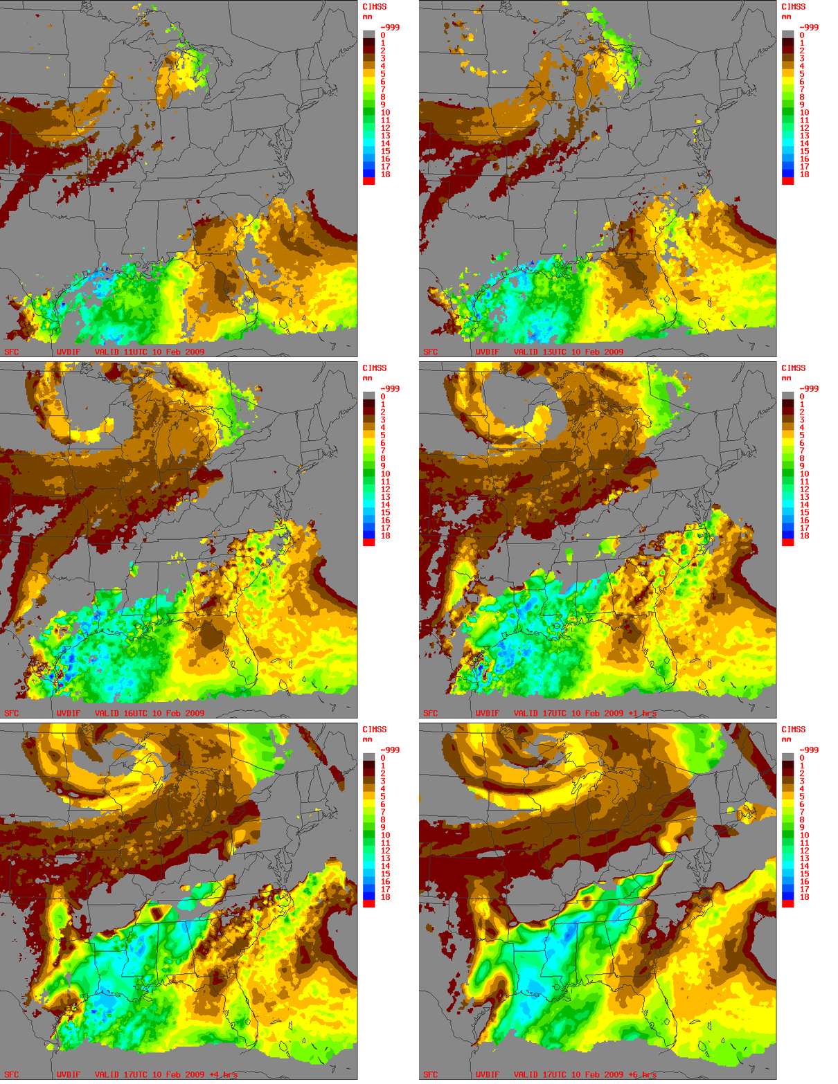
Information from the GOES-12 sounder Water Vapor channels helps to define the regions most susceptible to convection on that day, as shown in the loop above. This technique initializes a trajectory model with RUC winds and with precipitable water at different levels as retrieved from the GOES-12 sounder. The retrieval uses the 3 water vapor channels, channels 10 (7.4 microns), 11 (7.0 microns) and 12 (6.5 microns). (The shorter wavelength energy typically is emitted from higher in the atmosphere. GOES-12 weighting functions from Channel 10 typically peak around 600 or 700 mb; weighting functions from Channel 12 peak closer to 400 mb. (The exact level is, of course, a function of the airmass and the satellite viewing angle)). These three channels can help to define the distribution of water vapor in the atmosphere at different levels: the output of the retrieval that combines the brightness temperatures and initial guess soundings is precipitable water (mm) at different levels. Such a multi-layer description of the atmospheric water vapor is not possible with the single water vapor channel on the GOES imager; the multiple channels of the GOES sounder are required.
This model can predict areas of destabilization (convective potential) if “low” level moisture moves underneath “upper” level drying. The fields are presented as moisture change with height. If a region shows the moisture change with height increasing with time, then that region is becoming more convectively unstable. In the case shown above, observations are shown for the 6 hours before the ‘initial’ model time (17 UTC), and then output from the model — that is, short-range predictions (nearcasts) from a model using RUC winds and GOES Sounder PWs — is shown. Maximum destabilization is clearly indicated over central Oklahoma where supercells and tornadoes occurred. Note that for the 10 February case, the region of most interest aligns favorably with the line of convective development that initiated over central TX and central OK and produced supercell thunderstorms in the metro Oklahoma City area. In addition, the peak instability — as defined by the greatest decrease in precipitable water with height — occurs around 2100 UTC. Here is a radar image from that time. The predictions started from data at 1400 UTC, 1500 UTC, 1600 UTC, 1700 UTC (as above), 1800 UTC, 1900 UTC, 2000 UTC, 2100 UTC and 2200 UTC all show similar patterns. Note also that southeastern OK, also within the moderate risk, is diagnosed with somewhat less destabilization using this technique.
A second technique for discerning convective potential from satellite is discussed here.


