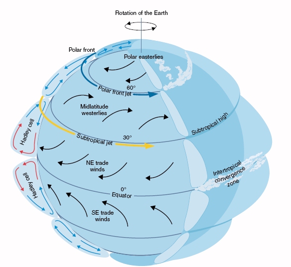
Currents: water masses in motion
Both the atmosphere and the oceans transport heat from low latitudes near the equator to high
latitudes near the poles. Cool air and water currents make the return trip from high latitudes back towards the equator. For the atmosphere, this circulation that globally
redistributes heat is accomplished by winds; for the ocean, it is accomplished by currents. In the most general sense, a current is a region of water that moves more
rapidly than its surroundings. There are surface ocean currents and deep ocean currents. We will learn about both here.
The transport of heat from equator to poles is not
distributed uniformly over the globe – it is concentrated in the major ocean currents. The strongest and most renown surface ocean currents are the Gulf Stream, that travels from the Caribbean Sea,
along the East coast of North America and across the Atlantic Ocean to Europe, and the Kuroshio Current in the North Pacific Ocean off the East coast of Asia.
In this lesson we will study these currents and will learn about the forces responsible for their movement.
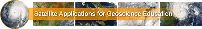
 Global Atmospheric Circulation (click image to enlarge) |
|
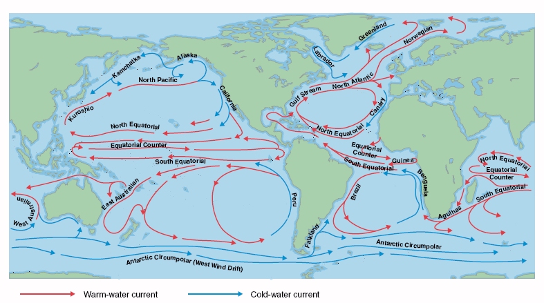
Ben Franklin's map of the Gulf Stream, circa 1786
AVHRR imagery of the Gulf Stream, 01 January 1985
(click on the image to learn more)
Currents are produced by physical forces
Ocean surface currents are caused by:
- Sun's energy
The oceans and atmosphere receive more energy from the Sun at low latitudes (closer to the equator) and receive less energy near the poles.
The Sun heats the oceans and atmosphere producing winds. When the winds blow over the oceans, they experience friction due to the ocean surface roughness. This frictional interaction results in transfer of energy to the sea surface and produces waves and currents. - Earth's rotation
The Earth’s rotation gives rise to a ‘virtual force’ known as the Coriolis effect. The Coriolis effect is an apparent deflection of objects moving on earth from a straight path due to the rotating frame of reference on earth. In the northern hemisphere this forces moving air and water to move in a clockwise spiral. In the southern hemisphere, the motion will spiral counterclockwise.
- Flow over and around topographical obstacles
Flow of ocean waters over undersea mountains and valleys also produces currents.
Deep ocean currents (also known as Thermohaline Circulation) are caused by:
-
The density of sea water varies globally due to differences in temperature and salinity. Surface water is heated by the sun, and warm water is less dense than cold water. Similarly, fresh water is less dense than salty water. At northern latitudes, surface water is cooled by extremely cold air. This cool water can becomes denser than the underlying water causing it to sink. The sinking and transport of large masses of cool water gives rise to the thermohaline circulation, which is driven by density gradients due to variations in temperature and salinity.
- The earth’s rotation also influences deep ocean currents
In general, wind-driven currents dominate the upper ocean, and thermohaline circulation drives the movement of the deep ocean.
How ocean currents are identified in satellite imagery
Ocean surface currents that are warmer than the surrounding water they may have a thermal signature, that can be seen in (Advanced Very High Resolution Radiometer (AVHRR) imagery. Depending on their thermal contrast (the temperature difference between the two water masses) ocean surface currents can have a strong or weak thermal signature. Ocean surface currents with a sufficiently strong thermal contrast, can be readily detected in sea surface temperature (SST) measurements, e.g. from AVHRR or Special Sensor Microwave/Imagery (SSM/I). Depending on wind conditions, warm currents can also be distinguished in Synthetic Aperture Radar( SAR) imagery, but this is a more subtle effect.
Altimeters obtain extremely precise measurements of the distance from the satellite’s position in orbit to the earth’s surface. These precise distance measurements enable us to estimate sea surface height, which can be used to identify regions of warm and cold water (since warm water expands, it ‘sits’ slightly higher than cold water), as well as to locate topographic features. The image below shows data acquired by the TOPEX/Poseidon satellite. This image uses color to show inferred ocean topography with arrows indicating the speed and direction of ocean currents. Notice how the currents move clockwise around higher regions in the ocean in the northern hemisphere. This is due to the Coriolis effect.
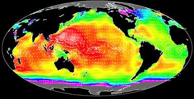
Satellite image showing global ocean currents
(click on the image to learn more)
|
Current affect local coastal climates and ecosystems | |
|
Upwelling refers to a process that is common along continental coastlines and at the equator. In coastal environments, winds coming off the land push the surface layers of water away from shore, producing a void at the surface. Cold, nutrient-rich water from underneath the surface layers rushes to the surface along the coast, filling this void. Cool water upwelling can be readily seen in SST data, and can be useful for locating good fishing locations, since the fish feed on the nutrients found within the cold water. At the equator, a different process results in upwelling of cold water. In this instance, water currents on either side of the equator are moving in opposite directions because of planetary rotation and the Coriolis effect. As these opposing currents rush past one another they 'peel back' the surface of the ocean, creating a void for deeper water to rush into and take its place. |
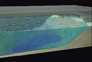 Upwelling (click on the image to learn more) |