29 March 1999 -- Stratospheric Intrusion Over Southern Wisconsin ?

|
|

|
|
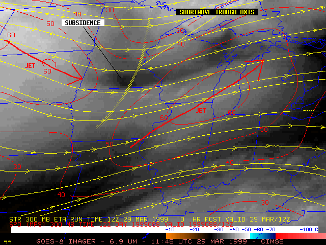
An upper-level shortwave trough and associated 60 m s-1 jet streak moved rapidly eastward across the southern Great Lakes region on 29 March 1999. NOAA GOES-8 6.7 micrometer InfraRed ("water vapor") imagery (above left) revealed a region of mesoscale warming in the wake of this shortwave, indicating subsidence and drying within the middle troposphere. GOES-8 visible imagery (above right) showed a lack of clouds over much of southern and central Wisconsin during the day, due to very dry air over that region. At the surface, dewpoints as low as 5 to 9 F (corresponding to relative humidities of 11-14%) were observed at some stations during the afternoon hours.
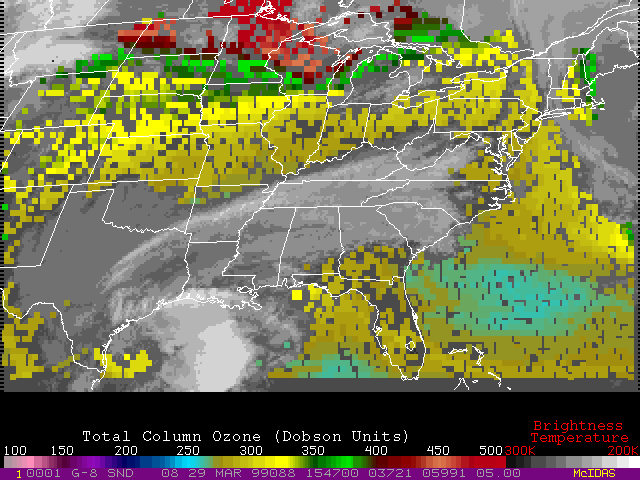
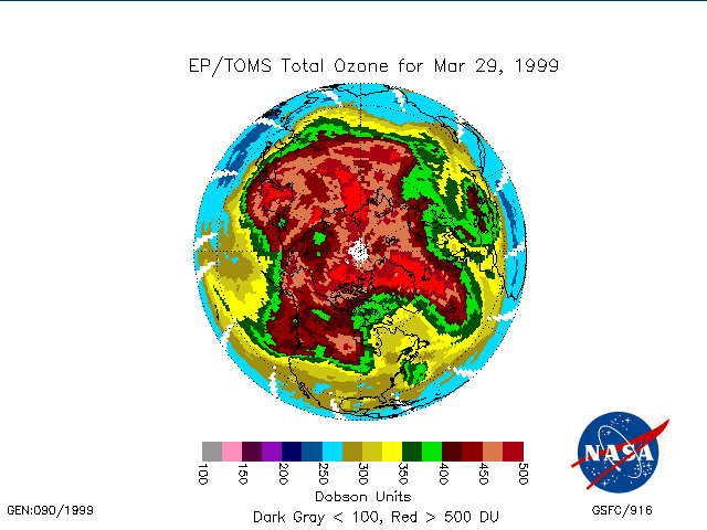
It is interesting to note that the decrease in surface dew points across southern Wisconsin corresponded to an increase in surface ozone concentrations (from 41 to 56 ppbv) at Devils Lake (a Department of Natural Resources monitoring station in southern Wisconsin) during the afternoon hours. GOES-8 Sounder experimental total ozone products (below left) showed that a lobe of high total column ozone concentration (greater than 400 Dobson Units) moved eastward across Wisconsin during the day, which could be a signature of a tropopause fold or stratospheric intrusion capable of introducing stratospheric ozone into the upper and middle troposphere. NASA TOMS total ozone images (below right) also show this lobe of high ozone (values above 400 Dobson Units) over the northcentral U.S. on 29 March. While the daily TOMS ozone product offers global coverage, the hourly ozone product from the GOES Sounder makes it easier to track the movement and evolution of transient ozone features.

|

|
Backward trajectories indicated that the lower tropospheric air mass arriving over southern Wisconsin had followed a southeastward transport path as it subsided across the Dakotas and southern Minnesota; isentropic cross sections of potential vorticity and relative humidity along this path show stratospheric values of PV within the middle troposphere (as low as 400-500 hPa) and very dry air (10-20% RH) over Minnesota and Wisconsin at 12:00 UTC on 29 March. The morning rawinsonde from Minneapolis MN shows a very low tropopause (around 400 hPa, or 7 km above the surface), with a well-mixed (nearly adiabatic) lapse rate between the tropopause and the surface. Moderate westerly winds (35 to 55 knots) and deep tropospheric subsidence in the wake of the departing upper-level shortwave may have aided the downward transport of stratospheric air (characteristically very dry, and high in ozone concentrations) into the lower troposphere and even to the surface. Surface time series plots from Baraboo/Wisconsin Dells (KDLL) and Madison (KMSN) show the drop in dew point during the afternoon, along with westerly to northwesterly winds which gusted up to 21-28 knots.
The pronounced subsidence and drying within the lower to middle troposphere is further illustrated by the three "water vapor" channels (channel 10 = 7.5um, channel 11 = 7.0um, and channel 12 = 6.5um) on the GOES-8 Sounder (below). Due to very low concentrations of water vapor within the tropospheric column on 29 March, the weighting function profiles for these 3 water vapor channels (calculated using 12:00 UTC Minneapolis rawinsonde data) were shifted to levels that are significantly lower than in a more "moist" standard atmosphere. This allowed prominent surface features (Lake Michigan, and Lake Winnebago in Wisconsin) to be sensed by the 7.5 micrometer water vapor channel during the afternoon hours.
|
|
|
|
