MODIS/GOES water vapor image comparison
|
|
MODIS/GOES water vapor image comparison
|
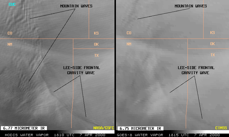
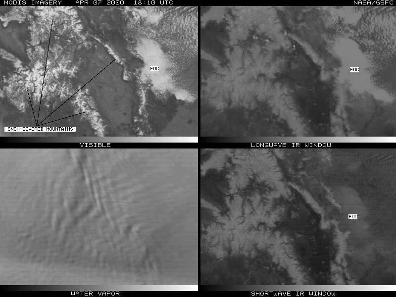
The image above shows a comparison between the early assessment phase NASA MODIS 6.77 micrometer InfraRed (IR) and the operational NOAA GOES-8 6.75 micrometer IR "water vapor" channels over the southwestern U.S. on 07 April 2000. Both images are remapped into a common (Mercator) projection. Two features of interest are much more apparent in the higher-resolution (1 km nadir field-of-view) MODIS data than in the GOES (3x8 km nadir field-of-view) data: (1) complex mountain waves over portions of Colorado and New Mexico, and (2) a thin convex-shaped lee-side frontal gravity wave associated with a surface cold front moving south-southwestward across the region.
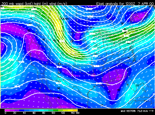
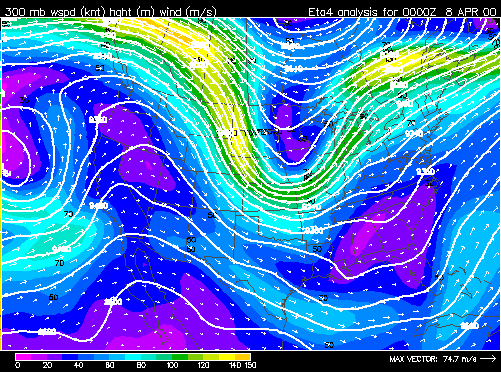
MOUNTAIN WAVES. The mountain waves over Colorado and New Mexico were induced by strong northwesterly flow (50-70 knots) associated with a pair of upper-tropospheric jet streaks moving across the elevated terrain of the southern and central Rocky Mountains that day (12 UTC | 00 UTC). The mountain waves appear more well-defined over Colorado -- in fact, several aircraft reported moderate to severe turbulence over that region. Two notable pilot reports included a "moderate mountain wave" which caused a fluctuation in aircraft speed between Mach 0.76 (513 knots) and Mach 0.85 (575 knots) at 39,000 feet over Denver, CO:
and an aircraft unable to maintain altitude due to strong downdrafts at 20,000 feet over Gunnison, CO (station identifier GUC on the image above):
It is important to note that these mountain waves occurred in clear air -- a multi-channel MODIS image over south-central Colorado shows that there were no wave clouds visible to indicate the turbulent flow regime across that region. Click here to interactively fade between the visible and water vapor image.
This MODIS/GOES image comparison offers a glimpse at the kind of detail that will be possible with the next generation of GOES Advanced Baseline Imager (ABI) imager data (2-km resolution IR channel data).
|
|
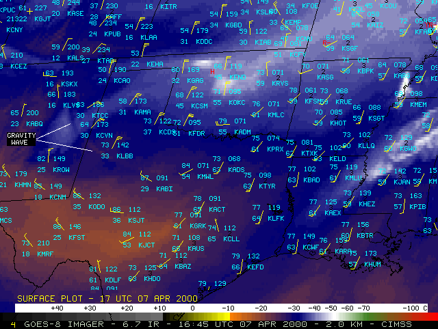
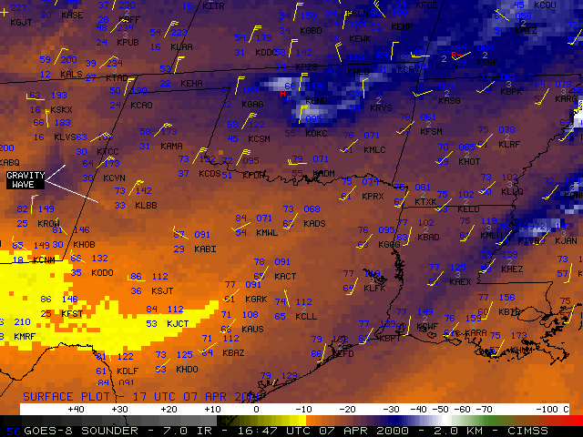
LEE-SIDE FRONTAL GRAVITY WAVE. The thin convex-shaped "band" seen on water vapor imagery across eastern New Mexico and western Texas was associated with a surface cold front lee of the Rockies that was moving south-southwestward across the region. Animations of color-enhanced GOES-8 imager 6.7 micrometer IR (above, left) and GOES-8 sounder 7.0 micrometer IR (above, right) "water vapor" channels show that the propagation of the thin warm/dry band coincides with that of the surface cold front -- the surface winds shift to northeasterly (and wind speeds increase to 25-30 knots) as the cold front passes. This band seen on water vapor imagery is an example of the vertically-propagating gravity waves above surface cold frontal zones modeled by Gall et al. (1988) and described by Ralph et al. (1999). These gravity waves are stationary with respect to the flow (they follow the front) and are forced by nongeostrophic and nonhydrostatic accelerations in the frontal zone (these waves above frontal surfaces are dynamically equivalent to stationary "trapped lee waves" that appear over mountains). Wave breaking induces narrow zones of subsidence that can be sensed as warm/dry bands on the water vapor imagery.
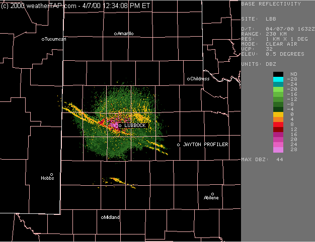
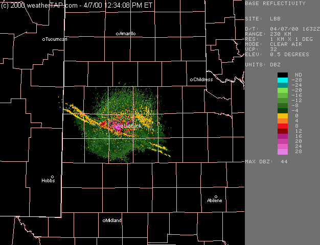
On the MODIS water vapor image shown earlier, there were subtle indications of a multiple-wave structure along the lee-side frontal gravity wave feature (especially near the New Mexico/Texas border, and across the Texas panhandle region). This multiple-wave structure is confirmed on the base reflectivity product from the Lubbock, TX WSR-88D radar (below, left) as the front moves southwestward past the radar site. A "tipped forward" structure of the surface cold frontal zone is evident on the 6-minute interval Jayton, TX NOAA wind profiler time series (below, right). The northerly winds arrive 1-2 km aloft over Jayton about a half hour before they arrive at the surface (Jayton is located about 75 miles / 115 km southeast of Lubbock). This tipped-forward structure can result from such processes as surface friction, adiabatic cooling in the leading-edge updraft, and turbulent mixing along the leading edge of the advancing front (Schultz et al., 1997). This case resembles another lee-side cold frontal gravity wave event over the same region on 28 January 1998.
|
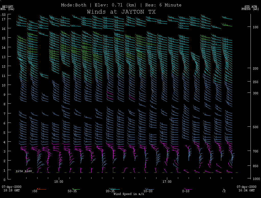
Jayton TX profiler time series (16:24 - 18:18 UTC)
|
(NIDS radar products provided by WeatherTap)
References:
Gravity waves generated during frontogenesis, Gall, R.L., R.T. Williams, and T.L. Clark, J. Atmos. Sci., 45, 2204-2219, 1988.Deep tropospheric gravity waves generated by leeside cold fronts, Ralph, F.M., P.J. Neiman, and T.L. Keller, J. Atmos. Sci., 56, 2986-3009, 1999.
The 1993 Superstorm cold surge: Frontal structure, gap flow, and tropical impact, Schultz, D.M., W.E. Bracken, L.F. Bosart, G.J. Hakim, M.A. Bedrick, M.J. Dickinson, and K.R.Tyle, Mon. Wea. Rev., 125, 5-39, 1997.


 (- Animated GIF 16:32 - 18:20 UTC -)