 Polar orbiting satellites travel in a circular orbit moving from pole
to pole. These satellites collect data in a swath beneath them as
the earth rotates on its axis. In this way, a polar orbiting satellite
can “see” the entire planet twice in a 24 hour period. The basic operational
mode deploys two polar orbiting satellites continuously, one passing
north to south (descending) and the other passing south to north (ascending),
circling the earth every 12 hours. Polar Orbiting Satellites are inserted
into sun-synchronous orbits which place the spacecraft in a relatively
constant relationship to the sun so that the ascending node will remain
at a constant solar time, permitting images and data to be received
by direct broadcast at the same time each day.
Polar orbiting satellites travel in a circular orbit moving from pole
to pole. These satellites collect data in a swath beneath them as
the earth rotates on its axis. In this way, a polar orbiting satellite
can “see” the entire planet twice in a 24 hour period. The basic operational
mode deploys two polar orbiting satellites continuously, one passing
north to south (descending) and the other passing south to north (ascending),
circling the earth every 12 hours. Polar Orbiting Satellites are inserted
into sun-synchronous orbits which place the spacecraft in a relatively
constant relationship to the sun so that the ascending node will remain
at a constant solar time, permitting images and data to be received
by direct broadcast at the same time each day.
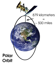
Polar Operational Environmetal Satellites
(POES) are
significantly closer to Earth than GOES, orbiting at an altitude
of only 879
kilometers, (approximately 500 miles) so it only takes one hour
and
42 minutes to complete a full orbit. This proximity results in high resolution
images and atmospheric profiles.
In a little bit we'll look at some sample images from the two different satellite orbits. But first let's move on to learning about the satellite instruments that provide us with the data for these images.
|