|
The Sea Breeze
The ability for the ocean to absorb and store energy from the sun is huge. This is due to...
- the transparency of the water that allows the sun's rays to penetrate deep into the ocean. In clear, tropical water, light can reach a depth of 500-650 feet (150-200 meters) meaning that is takes a great amount of heat to raise the temperature over such a large volume of water, and
- the constant turbulence from wind and weather continually mix the water distributing heat over large volumes requiring even more heat to raise the temperature.
In contrast to the ocean, the sun's rays do not to penetrate deep into dry ground but are confined typically to just a few inches at the top. Consequently, the land on a daily basis, while it heats up many times more rapidly than the ocean also can loose that heat just as rapidly at night.
For coastal areas, this difference on heating can have a large impact on the weather by the formation of the sea and land breezes and is in fact the basic reason we observe wind in the first place. While the sea breeze are generally associated with the ocean, they can occur along the shore of any large body of water such as the Great Lakes.
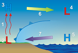
The sea breeze circulation is comprised of two opposing flows; one at the surface (called the sea breeze) and one aloft (which is a return flow). These two flows are a result of the difference in air pressure between the land and sea generated by the sun's heating.
 At the surface, the sun warms both the ground and ocean at the same rate. However, since the heat in the ground is not absorbed well it returns it heat to warm the air. The warmed air, with its decreased density, begins to rise (1). The rising air creates a weak low pressure area (called a thermal low) due to a decrease in air mass at the surface (2). Typically, from 3,000 to 5,000 feet (1,000 to 1,500 meters) above this low pressure, as the air cools, it begins to collect resulting in an increase in pressure, creating a "high" (3). At the surface, the sun warms both the ground and ocean at the same rate. However, since the heat in the ground is not absorbed well it returns it heat to warm the air. The warmed air, with its decreased density, begins to rise (1). The rising air creates a weak low pressure area (called a thermal low) due to a decrease in air mass at the surface (2). Typically, from 3,000 to 5,000 feet (1,000 to 1,500 meters) above this low pressure, as the air cools, it begins to collect resulting in an increase in pressure, creating a "high" (3).
These differences in pressures over land, both at the surface and aloft are greater than the differences in pressures over water at the same elevations (4 and 5). Therefore, as the atmosphere seeks to reestablish equal pressure both onshore and offshore, two high pressure to low pressure airflows develop; the offshore flow aloft (6) and surface onshore flow, called the sea breeze (7).
Because of the temperature difference between the surface temperature over land and over water are typically large, a sharp boundary can develop. This boundary, called a sea breeze front, acts the same as the cold front we are use to experiencing. Just like cold fronts, the air temperature drops significantly after the sea breeze front passes a location, sometimes as much as 15-20°F (°C). The skies also clear after the sea breeze front pass by. Another change that takes place with the passage of the sea breeze front is an increase in humidity. Finally, there is a significant change in wind direction and/or speed.

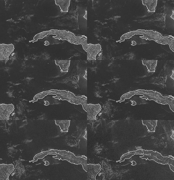
Opposing sea breezes meeting over Cuba forming a line of cumulus clouds |
These changes occur in a relatively small scale weatherwise. However, if there are larger scale atmospheric conditions also affecting the weather, then the sea breeze and sea breeze front can have a much larger impact on the type and intensity of weather one observes. Just like along cold fronts, if weather conditions are right, thunderstorms often develop along sea breeze fronts.
The location and amount of thunderstorms will vary depending on the overall weather pattern over the region. For example, in Florida, the amount of sunshine and prevailing surface wind over the state has a large impact on sea breeze thunderstorms. If the wind is relative calm then the sea breeze can move will inland but with only scattered thunderstorms occurring about 1/3rd of the way across the peninsula.
Light west wind (5-10 mph) keeps the sea breeze front confined to the eastern coast but also makes for more widespread thunderstorms along the boundary. Stronger west winds prevent can the sea breeze front from moving onshore, or forming at all, so no thunderstorms will occur.
With prevailing east winds, they actually help push the sea breeze front and thunderstorms as much as half way across the peninsula.
On smaller peninsulas, such as at the northern tip of New Zealand, sea breezes from opposite coasts may collide. In these situations, two lines of thunderstorms may collide and combine into a single but intense, short-lived line.
 The opposite of a sea breeze is a land breeze. While sea breezes occur during the day, land breezes occur at night. Despite the difference in times at which the land breezes and sea breezes occur, the reason for the land breeze's formation is the same as the sea breeze, just the role of the ocean and land is reversed. The opposite of a sea breeze is a land breeze. While sea breezes occur during the day, land breezes occur at night. Despite the difference in times at which the land breezes and sea breezes occur, the reason for the land breeze's formation is the same as the sea breeze, just the role of the ocean and land is reversed.
Land breezes can occur when the the land's nighttime temperature is less than the sea surface temperature. They are most common during the fall and winter seasons when water temperatures are still fairly warm and nights are cool. However, unlike the sea breeze, the land breeze is usually weaker.
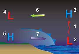
At night, the land temperature falls to below that of the ocean and becomes less dense. Therefore it begins to rise (1, above right). The rising air creates a weak low pressure area due to a decrease in air mass at the surface (2). As the air cools, it begins to collect resulting in an increase in pressure, creating a "high" (3).
These differences in pressures over the water, both at the surface and aloft are greater than the differences in pressures over land at the same elevations over the water (4 and 5). Therefore, as the atmosphere seeks to reestablish equal pressure both onshore and offshore, two high pressure to low pressure airflows develop; the onshore flow aloft (6) and surface offshore flow, called the land breeze (7).
Land breezes are weaker than sea breezes but not because of the difference in heating. Daytime heating and nighttime cooling occur at about the same rate so the potential for the both land and sea breezes to be the same strength exists. But at night,
- The cooling ground inhibits vertical motion which, in turn, weakens the land breeze circulation,
- Nighttime cooling also produces a shallower change in temperature so land breeze circulation is shallower, and
- Terrain, vegetation, and buildings inhibit the flow of air from land to water.
|
|


