Ocean color
When light hits the surface of an object, different colors are reflected or absorbed, depending on the properties of the material. The colors we see depend on which colors are reflected and which are absorbed. This principle holds true for the ocean; its color depends on absorbance and reflectance of light due to roughness of its surface and suspended microorganisms and particles.
When sunlight hits the ocean, some of its energy:
-
Is reflected or scattered from the sea surface
The amount depends on surface roughnes. Reflected light is observed as sun glint.
-
Penetrates the ocean surface, i.e. is transmitted
In clear water, light can penetrate to depths of about 200 m. In sea water the red portion of the sunlight is quickly absorbed very near the surface, which is why the colors in most underwater photographs appears very blue. And light that is scattered back out of clear, open ocean water is blue.
In water with many suspended particles, such as coastal areas, light only penetrates a few meters due to the presence of pollution, runoff from rivers, suspended particles of sand and silt moved by tides, waves and storms. Depending on composition and amount of materials or organisms in the water, approximately 60% of the light incident on the sea surface is absorbed in the first meter of depth; approximately 80% of the light is absorbed in the first 10 meters. This absorbed light warms the upper layer of the oceans.
Phytoplankton are microscopic, single-celled plants that grow in the ocean. They contain a pigment called chlorophyll, which absorbs red and blue light and reflects green light during the process of photosynthesis. Under certain environmental conditions, phytoplankton can reproduce to the extent that they change the color of the ocean measured from space and the green light reflected by cholorophyll can be seen directly in true color images of the ocean.
Sensing ocean color from space
SeaWifs (Sea-viewing Wide Field-of-view Sensor) is a satellite designed for monitoring ocean color from space to estimate the abundance of chlorophyll and phytoplankton in ocean water, and to monitor the change in these quantities with location and time. It can also be used to estimate bathymetry and identify and predict harmful algal blooms
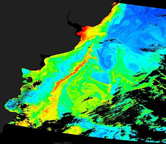
In this image pair we compare a true color SeaWifs image and an enhanced (false color) image of the Bering Sea, where the color indicates the estimated cholorophyll concentration which is linked to the presence and prevalence of phytoplankton in a region.
Image used with permission from xxxxx.
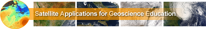
Here consider a SeaWifs false color image showing phytoplankton off coast of Argentina. Dark regions are the continent of South America and colors indicate ocean chlorophyll concentration due to phytoplankton and sediments. High concentration of chlorophyll due to phytoplankton (indicated by red, orange, and yellow) are seen in the Brazil Current Confluence region east of Argentina. Image color indicating sediment particles can be seen in coastal areas in the Rio de la Plata estuary, where the Parana and Uruguay Rivers meet the ocean.
Image used with permission from xxxxx.
Sea Surface Height (SSH)
The height of the sea surface is governed by gravity, temperature and ocean currents. Measurements of SSH can be used to understand ocean circulation, ocean tides, climate cycles like El Niño and La Nina, and also sea-level rise. Typically, scientists study ‘Sea Surface Height Anomalies’, or the deviation of SSH data from its average value. This quantity can be obtained by taking the difference between the measured SSH, obtained by an altimeter such as the one on board the TOPEX/Poseidon satellite, at a particular location and the average SSH for the same location.
El Nino is the name given to a temperature fluctuation corresponding to warmer than normal sea surface temperatures, that occurs in the ocean-atmosphere system in the eastern Pacific Ocean that exert significant consequence world-wide. La Nina events correspond to colder than normal temperatures. El Nino events are associated with increased rainfall in the Southern US and in Peru, and droughts in Indonesia and Australia. During El Niño events, the trade winds relax in the central and western Pacific, which results in a rise in sea surface temperature and a drastic decline upwelling water bearing nutrients for fish.
In addition to enabling us to identify and track El Nino events, long-term altimeter measurements of sea-surface height make it possible for us to track sea level rise due to global warming, and to identify locations of areas of warm water which can be linked to hurricane formation.

Movie illustrating the evolution of an SSH Anomaly in the equatorial Pacific Ocean over the course of the intense 1997 -98 El Nino/La Nina events.
Used with permission from xxx.