30 May 1998 -- Tornado Outbreak in South Dakota
GOES-8 Imager Products:
|
|
|
|
|
Severe thunderstorms erupted along a cold front that began to move rapidly eastward across the northern Plains late in the day on 30 May 1998. This convection first produced large hail and tornadoes in South Dakota, including the multiple vortex F4 tornado that killed 6 people and injured over 150 others in Spencer. These storms continued to propagate eastward, developing into a derecho-type of mesoscale convective system that affected parts of the Upper Midwest, the Great Lakes, and eventually New England (Wikipedia).
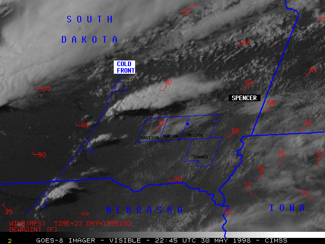
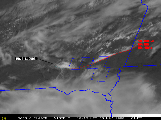
GOES-8 satellite features: The NOAA GOES-8 visible imagery (above left) covers the time period following the early morning convection over that region, leading up to the initial development of the new convection that eventually spawned the Spencer SD tornado. A curved boundary can be seen migrating southward through the highlighted counties (from 15:45 to about 19:32 UTC); this boundary appears to have been an outflow boundary or gravity wave feature generated by convection over North Dakota early that morning. The western portion of this cloud boundary then appears to surge back to the north from 20:32 to 22:15 UTC, as the cold front begins to propagate eastward toward the Missouri River. Convection develops near the cold front / cloud boundary intersection, and moves toward the affected counties.
Convective initiation often occurs near the periphery of pre-existing boundary layer wave cloud (or "cloud band") features 1. Note the formation of low to middle level wave clouds over north central and northeastern South Dakota (well north of the outlined counties) from about 19:45 to 22:02 UTC; strong convection (producing 1.75 inch diameter hail) develops near the southwestern edge of this wave cloud region at 23:02 UTC. Very subtle wave clouds can also be seen along the extreme western edge of the southward-moving boundary (between 17:02 and 18:15 UTC, just west of the outlined counties).
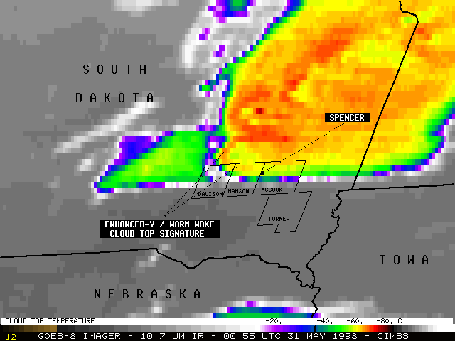
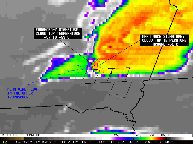
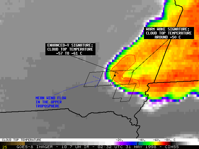
GOES-8 10.7 micron longwave IR imagery (above right) shows that an enhanced-V / warm wake cloud top signature 2 was first evident just north of Davison county on the 00:55 UTC image (about 20 minutes prior to the first tornado in Hanson county, and about 50 minutes prior to the Spencer tornado). Another enhanced-V / warm wake signature was apparent on the 23:32 UTC image in northeastern South Dakota, associated with the storm which produced 1.75 inch diameter hail around 23:30 UTC. Note how the coldest cloud tops (orange and red enhancement, -60 to -70 C) over northern portions of Davison and Hanson counties appear to build back to the southwest after about 01:30 UTC -- this was a result of a cell merger between the original Spencer tornadic supercell and the new convection which was building just to the southwest. Following this cell merger, the enhanced-V / warm wake cloud top signature became larger and more well defined after 02:00 UTC.
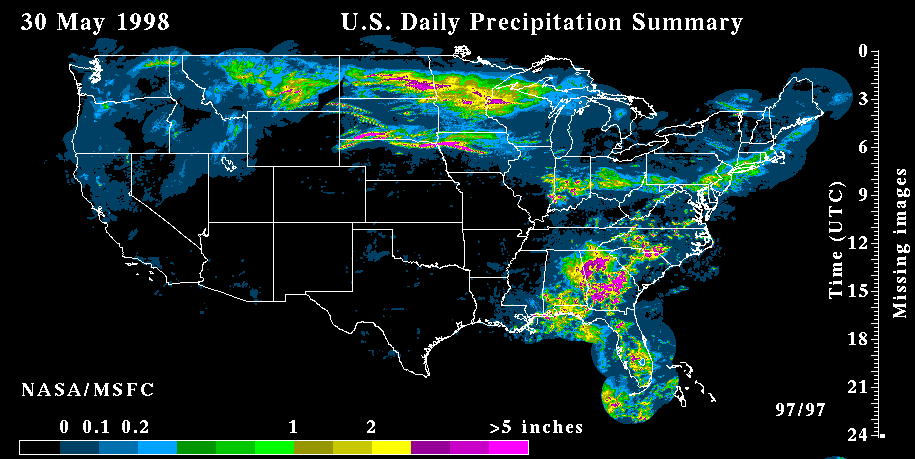
A loop of GOES-8 3.9 micron shortwave IR imagery shows that the early morning convection which moved across the region left in its wake a swath of wet ground from precipitation. This wet ground is delineated by cooler 3.9 micron brightness temperatures (lighter gray enhancement) from southwestern Minnesota / northwestern Iowa into northeastern Nebraska. Compare the location of the 3.9 micron wet ground swath with the radar-estimated precipitation from 30 May. Differential heating along the wet ground - dry ground boundary may have played a role in the movement and intensification of the supercell convection that formed later that evening and affected the outlined counties.
|
|
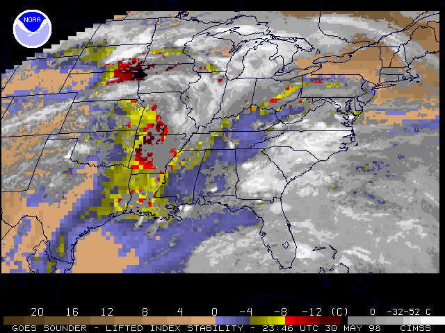
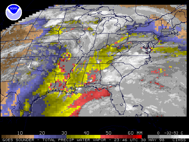
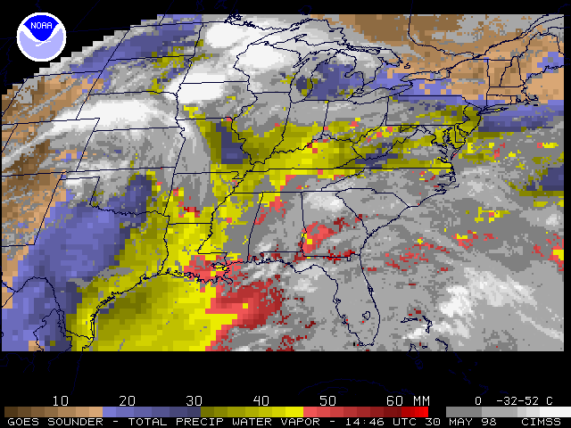
GOES-8 sounder derived Lifted Index (LI) and Total Precipitable Water (TPW) are shown above. These sounder derived product imagery indicate that the atmosphere over southeastern South Dakota recovered rapidly in the wake of the early morning convection that moved across that region -- the atmosphere remained unstable (LI values of around -8 C, increasing to -12 to -15 C by 23:46 UTC) and had ample moisture (TPW values of 30-40 mm, increasing to 46-48 mm by 23:46 UTC).
References:
1 Relationship Between Cloud Bands in Satellite Imagery and Severe Weather, Beckman, S.K., in "Satellite Imagery Interpretation for Forecasters", Vol. 2, 4-C-1, National Weather Association, 1993.2 The Enhanced-V: A Satellite Observable Severe Storm Signature, McCann, D.W., in "Satellite Imagery Interpretation for Forecasters", Vol. 2, 4-I-1, National Weather Association, 1993.
Address any questions or comments to the GOES Webmasters
