Weather Satellites and Weather Forecasting

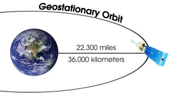
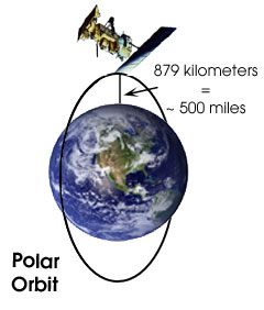
Weather Satellites

The first forecasting tool we'll cover are images provided by weather satellites. A satellite is an object that orbits a larger object, like a planet. The earth’s moon is an example of a natural satellite; weather satellites are the result of human invention. The same forces that hold satellites in their orbits around the Earth keep planets in their orbits around the sun.

There are two main types of weather satellites, defined by their orbits around the Earth.
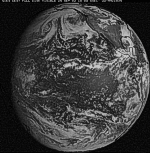
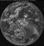
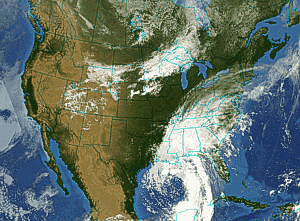

Geostationary Orbiting Environmental Satellites (GOES) provide continuous images of the same area on Earth 24 hours a day. They hover over a single point above the Earth's equator at an altitude of about 36,000 kilometers (22,300 miles). This is about one-tenth of the way to the moon. GOES satellite images are the type you'll see on the evening news or the Weather Channel and are great for monitoring the weather.

Polar Orbiting Environmental Satellites (POES) Polar orbiting satellites travel in a circular orbit from pole to pole, much closer to the Earth than GOES. These satellites collect data in a path beneath them as the earth rotates on its axis. In this way, a polar orbiting satellite can “see” the entire planet twice in a 24 hour period. Currently we have morning and afternoon polar satellites in orbit. They provide images of the entire Earth four times daily. While they aren't as useful to watching the weather as GOES, they are extremely valuable because they provide such fantastic detail of storms, volcanoes, mudslides, wildfires and other natural events on Earth.

The United States operates two GOES weather satellites, one over the East Coast and one over the West Coast. They have overlapping coverage in the central United States. Here are the views from each satellite. Be sure to click on these images to make them bigger.  
GOES West   GOES East
Full disk GOES West visible image - Click to enlarge Full disk GOES East visible image - Click to enlarge
Colorized and combination GOES Weast and East satellite image of the 
contential U.S.
We use computers to add color or otherwise enhance satellite images. Probably the most common enhancement is combining both GOES West and East into one image of the whole United States. This changes the perspective and makes it look like the satellite is directly over the center of the U.S. like the image to the left. (from the same time as the two full disk views above)


Continue...