
Weather Forecasting

Station Weather Plots and Symbols
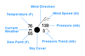
Station Weather Plot
Satellite images, fronts, isobars, highs and lows show large scale weather features and help us see the big weather picture. However, meteorologists need to look closer at the weather data with more detail. One common way is with station weather plots. The station weather plot shows the current weather conditions, cloud cover, wind speed, wind direction, visibility, temperature, dew point temperature, atmospheric pressure, and the change in pressure over the last three hours. Here is an example of a surface station weather plot (in black) with labels explaining the data (in blue).
Sky Cover:
The amount that the circle at the center of the station plot is filled in represents the approximate amount of total cloud cover. In above case, the sky cover is overcst. Below are the common sky cover depictions.
 |
 |
 |
 |
 |
 |
 |
| Clear | Scatterd (25%) |
Partly Cloudy (50%) |
Mostly Cloudy (75%) |
Overcast | Sky Obscured | Data Missing |
Wind:
The longer line, extending from the sky cover plot, points in the direction that the wind is blowing FROM. The shorter lines, called barbs, on the outer end of the direction line indicate the wind speed in knots (kt). Each long barb represents 10 kt with short barbs (half-lines) representing 5 kt, and each flag represents 50kt. In above case, the wind is blowing FROM the northeast and the wind speed is 25 knots. Below are some more examples of wind plots.
 |
|||||
| Calm winds | 5 knots | 15 knots | 20 knots | 35 knots | 65 knots |
Pressure & Pressure Trend:
See-level pressure is plotted to the nearest tenths of millibars(mb), with leading 9
or 10 omitted. For example:
- if the pressure was plotted as 028, the complete sea-level
pressure value is 1002.8 mb;
- if the pressure was plotted as 462, it would be 1046.2 mb;
- if the pressure was plotted as 867, it would be 986.7 mb.
When trying to determind
whether to add a 9 or 10 use the number that will give you a value CLOSEST to 1000 mb
The pressure trend has two components, a number and symbol, to indicate how much (in tenths of millibars) in the past 3 hours and the trend in the change of the pressure during the same period. In above case, the pressure was falling after steady or slightly rising and becoming 3 mb LOWER than it was three hours ago. Below are the meanings of the pressure trend symbols.
| Steady | Rising, then steady | Falling, then steady | |||
| Continuously Rising | Rising after slightly falling | Rising, then slowly falling | |||
| Continuously Falling | Falling after slightly rising | Falling, then slowly rising |
Weather Symbols
| General | |||||
|---|---|---|---|---|---|
 |
Smoke |  |
Lightning |  |
Rain Shower |
 |
Haze |  |
Funnel Cloud |  |
Snow Shower |
 |
Dust |  |
Mist |  |
Hail |
 |
Blowing Snow |  |
Heavy Fog |  |
Thunderstorm |
| Precipitation at Time of Observations | ||||
|---|---|---|---|---|
| Type | Light | Moderate | Heavy | Freezing |
| Drizzle |  |
 |
 |
 |
| Rain |  |
 |
 |
 |
| Snow |  |
 |
 |
 Sleets |
 Here
are a few practice exercises decoding station weather plots. Click on an exercise to
start.
Here
are a few practice exercises decoding station weather plots. Click on an exercise to
start.
Have fun and good luck!
Excercise 1 |
Excercise 2 |
Excercise 3 |
Excercise 4 |
Excercise 5 |
Excercise 6 |
Excercise 7 |
Excercise 8 |
Excercise 9 |
| 5 / 12 |