
Weather Forecasting

Highs and Lows
Air is lifted in and around areas of low pressure. Remember, air pressure is the weight
of the atmosphere above you. When there is a large area of low pressure, there is less
air above so the air at the surface tends to rise. Alternatively, an area of high pressure
is like a hill of air in the atmosphere. The air in and around high pressure sinks
and spreads outward at the surface.
Another way to think about low and high pressure is to consider how and why the wind
blows. Wind is air in motion. The wind blows from areas of high pressure to areas
of low pressure. It's diretion is influenced by the Earth's rotation. Some of this
is rising and sinking air (vertical motion) but most of the time when we talk about
winds we are talking about horizontal motion along the surface. A forecast of south
winds of 12 to 20 mph means the surface winds will be 12 to 20 miles per hour FROM
the south.
 |
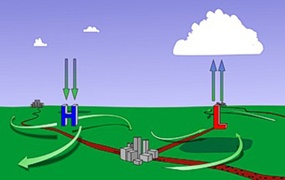 |
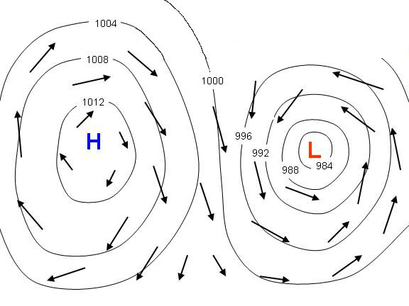
| A large blue H is used to indicate the center of high pressure areas on a map while large red L's mark the center of low pressure. | General pattern of air flow around low and high pressure |
The lines around high and low pressure on a weather map are called isobars,
or lines of equal pressure, as shown in the above image on the left. When isobars
are close together it is very windy; when they are further apart, conditions are
more calm. The wind around highs always blows in a clockwise direction. ("clockwise" refers
to the direction that the hands on a clock tick) and winds around lows flows in the
opposite direction, or counter-clockwise.
This image on the right shows the general pattern of air flow around low and high pressure.
Air is feeding into the center of a low at the surface in a counter-clockwise direction.
When the air meets in the middle of a low, it has to rise (it can't dive down into
the Earth) and as it cools clouds are formed. The opposite circulation occurs around
highs with sinking air spreading out in a clockwise direction.
An L on a weather map shows where the weather action is. Low pressure regions always
create clouds and usually precipitation because the rising air cools and the water
vapor condenses. High pressure regions are usually associated with dry weather because
as the air sinks it gradually warms up and the moisture evaporates.
| 4 / 12 |