Alabama MCS
A mesoscale convective system (MCS) traversed the state of Alabama producing at least 200 damaging wind reports.
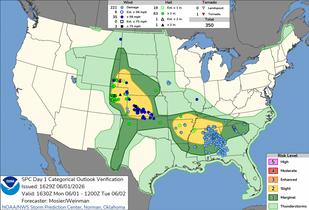
Here is the SPC outlook discussion for this region. Interestingly, the western threat (in MO/AR) didn’t materialize nearly to the extent of the MCS in Alabama. The MCS was characterized by lots of CAPE (2500-3500 J/kg), adequate effective shear (25-35 kt), and steep low-level lapse rates (~ 8 C/km).
...Mid-South into the Southeast...
   An MCS is currently progressing generally southeastward, with
   preceding outflow arcing from southeast MO through far northwest TN.
   Some brief intensification was noted along this outflow, although
   updraft strength continues to be somewhat transient. General
   expectation is for this pattern of brief intensification to continue
   for the next hour or two, before building instability along the
   western edge of the outflow results in updraft/downdraft cycles
   strong enough to produce strong to severe gusts. However, given
   limited deep-layer shear, overall updraft organization will likely
   remain transient.

   Additional new development is anticipated farther west during the
   afternoon from south-central MO into northern AR (and perhaps
   western TN and northern MS). Dewpoints in the 70s amid afternoon
   high temperatures in the upper 80s/low 90s will support very strong
   buoyancy, with MLCAPE values around 4000 J/kg. This buoyancy will
   support robust updrafts, but weak shear will limit storm
   organization, contributing to an outflow-dominant, multicellular
   mode. Even with limited organization, the updraft/downdraft cycles
   should be strong enough for widespread strong/severe storms capable
   of damaging wind gusts and some isolated hail.

   The storms, whether with the ongoing cluster or newer development
   farther west, may spread as far south as central MS/AL during the
   evening before weakening.
The ProbSevere v4 model tracked this system quite well, with moderate to strong probabilities throughout, except for the very end in southeast Alabama. At this point, lightning activity was zero or very low, and it’s possible a strong gust front out ahead of the updrafts was causing the wind damage. NWS warnings also followed the convection well, as both NWS and PSv4 forecasts corresponded with next-45-minute reports. NWS did indeed capture the wind damage in southeast Alabama better than PSv4. We have noticed the PSv4 tends to excel at predicting organized convection but struggles often in low-lightning convection (though not always).
Here is a still image, where we can see the PSv4 predictions for the MCS as well as a southeast-moving storm on the South Carolina border.
