Imager and Sounder Fusion Research
The ‘imager plus sounder’ (or imager/sounder) fusion method was originally developed to create the missing CO2 absorption band at 13.3 microns for VIIRS (Cross et al., 2013) to complement the existing IR window bands. Subsequently Weisz et al. (2017) constructed any desired IR absorption band radiance by merging high spatial resolution imager data with high spectral (but coarse spatial) resolution sounder data. MODIS spectral bands are replicated in VIIRS/CrIS fusion with brightness temperatures within 0.5°C (1.0°C) for CO2 (H2O) sensitive bands. The addition of CO2 absorption bands (essential for cloud top height and phase, as well as temperature soundings) and water vapor absorption bands (important for tropospheric moisture determinations) enables the continuity of the data records established by HIRS and MODIS.
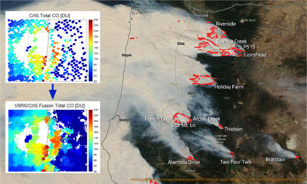
Beyond just radiances, fusion has been used to create retrieval products (such as temperature and humidity at specific levels or total trace gas amounts) at the imager’s high spatial resolution (Weisz and Menzel, 2019 and 2020). Imager/sounder fusion has been applied not only to polar-orbiting instrument pairs (e.g., VIIRS/CrIS, AVHRR/IASI, AVHRR/HIRS) but also to pairs in different orbits (e.g. ABI in geostationary orbit (GEO) and CrIS in low-earth orbit (LEO)). GEO/LEO fusion also provides the opportunity to create sounder data and products more frequently (at times different from the LEO overpass) through temporal fusion.
Five research areas (VIIRS/CrIS fusion of radiances and associated cloud, moisture, and trace gas retrievals, ABI/CrIS atmospheric stability trends, and ABI/TROPOMI trace gas monitoring) are briefly described under the link above.
Publications
Borbas, E. E., E. Weisz, C. Moeller, W. P. Menzel, and B. A. Baum, 2021: Improvement in tropospheric moisture retrievals from VIIRS through the use of infrared absorption bands constructed from VIIRS and CrIS data fusion, Atmospheric Measurement Techniques. 14, 1191–1203, doi.org/10.5194/amt-14-1191-2021, 2021.
Cross, J., I. Gladkova, W. P. Menzel, A.Heidinger, and M. D. Grossberg, 2013: Statistical estimation of a 13.3 µm Visible Infrared Imaging Radiometer Suite channel using multisensor data fusion. J. Appl. Remote Sens. 7 (1), 073473. doi: 10.1117/1.JRS.7.073473
Li, Yue, B. A. Baum, A. K. Heidinger, W. P. Menzel, E. Weisz, 2020: Improvement in cloud retrievals from VIIRS through the use of infrared absorption channels constructed from VIIRS-CrIS data fusion, Atmospheric Measurement Techniques. 13, 4035–4049, doi.org/10.5194/amt-13-4035-2020, 2020.
Weisz, E., B. A. Baum, and W. P. Menzel, 2017: Fusion of satellite-based imager and sounder data to construct supplementary high spatial resolution narrowband IR radiances. J. Appl. Remote Sens. 11(3), 036022, doi: 10.1117/1.JRS.11.036022.
Weisz, E., and W. P. Menzel, 2019: Imager and sounder data fusion to generate sounder retrieval products at an improved spatial and temporal resolution, J. Appl. Remote Sens. 13(3), 034506, doi: 10.1117/1.JRS.13.034506.
Weisz, E., and W. P. Menzel, 2020: An Approach to Enhance Trace Gas Determinations through Multi-Satellite Data Fusion, J. Appl. Remote Sens. 14(4), 044519 (2020), doi: 10.1117/1.JRS.14.044519.