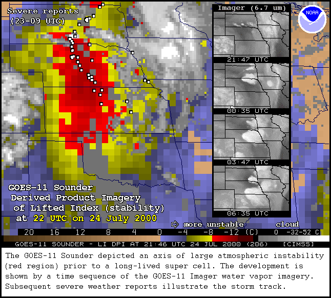
July 24-25, 2000 Derived Products
Three tornado reports were made, two in South Dakota and one in Nebraska, several hours after atmospheric instability was found
using the GOES-11 Sounder. The storm continued to move south across this area with hail as large as 2 inches and
damaging winds being reported for the next 12 hours according to the NOAA Storm Prediction Center (SPC). The
SPC Storm Report for 000724 contains more information.
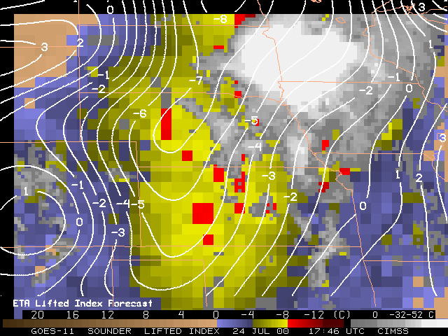
Eta Model Forecasts of Lifted Index (above, right)
Forecasts of Lifted Index from the Eta model (from the 12 UTC run) are
plotted over the sounder Lifted Index (LI) Derived Product Images (DPI).
The model forecasts also captured the general region of large instability
over Nebraska and Kansas. Although, the sounder LI values were more
unstable and showed a tighter gradient. The overall similarity of the Eta
forecast and the sounder DPI is not surprising. This is because retrieved
moisture data from both the GOES-8 and -10 sounders (which use the Eta
forecasts as a first guess) were being assimilated in the Eta system during
this time.
Products
GOES-11 Derived Products: Precipitable Water
| Lifted Index | Cloud Top Pressure
Individual GOES-11 Sounder Bands: Multi-Panel Display
GOES-11 Precipitable Water coverage within entire conterminous US
This display of the total precipitable water vapor (PW) as
derived from the GOES-11 Sounder is provided each hour, matching the similar
display from the "operational" GOES-8 and GOES-10 Sounders. For more
description of the GOES Sounder PW DPI as well as longer animations from
GOES-8 and GOES-10, see the
PW section
of the CIMSS Realtime GOES Page.
24-hour java animation of GOES-11 Sounder PW DPI
 GIF Images for 25 July 2000
15:00 UTC;
14:00 UTC,
13:00 UTC,
12:00 UTC,
11:00 UTC,
10:00 UTC,
09:00 UTC,
08:00 UTC,
07:00 UTC,
06:00 UTC,
05:00 UTC,
04:00 UTC,
03:00 UTC,
02:00 UTC,
01:00 UTC,
00:00 UTC
GIF Images for 25 July 2000
15:00 UTC;
14:00 UTC,
13:00 UTC,
12:00 UTC,
11:00 UTC,
10:00 UTC,
09:00 UTC,
08:00 UTC,
07:00 UTC,
06:00 UTC,
05:00 UTC,
04:00 UTC,
03:00 UTC,
02:00 UTC,
01:00 UTC,
00:00 UTC
GIF Images for 24 July 2000
23:00 UTC,
22:00 UTC,
21:00 UTC,
20:00 UTC,
19:00 UTC,
18:00 UTC,
17:00 UTC
GOES-11 Lifted Index (stability) coverage within entire conterminous US
This display of the lifted index (LI) stability as
derived from the GOES-11 Sounder is provided each hour, matching the similar
display from the "operational" GOES-8 and GOES-10 Sounders. For more
description of the GOES Sounder LI DPI as well as longer animations from
GOES-8 and GOES-10, see the
LI section
of the CIMSS Realtime GOES Page.
24-hour java animation of GOES-11 Sounder LI DPI
GIF Images for 25 July 2000
15:00 UTC,
14:00 UTC,
13:00 UTC,
12:00 UTC,
11:00 UTC,
10:00 UTC,
09:00 UTC,
08:00 UTC,
07:00 UTC,
06:00 UTC,
05:00 UTC,
04:00 UTC,
03:00 UTC,
02:00 UTC,
01:00 UTC,
00:00 UTC
GIF Images for 24 July 2000
22:00 UTC,
21:00 UTC,
20:00 UTC,
19:00 UTC,
18:00 UTC,
17:00 UTC
GOES-11 Cloud Top Pressure coverage within entire conterminous US
This display of the cloud top pressure (CTP) as
derived from the GOES-11 Sounder is provided each hour, being similar to
displays from the "operational" GOES-8 and GOES-10 Sounders. For more
description of the GOES Sounder CTP DPI, see the
CTP section
of the CIMSS Realtime GOES Page.
24-hour java animation of GOES-11 Sounder CTP DPI
GIF Images for 25 July 2000
15:00 UTC,
14:00 UTC,
13:00 UTC,
12:00 UTC,
11:00 UTC,
10:00 UTC,
09:00 UTC,
08:00 UTC,
07:00 UTC,
06:00 UTC,
05:00 UTC,
04:00 UTC,
03:00 UTC,
02:00 UTC,
01:00 UTC,
00:00 UTC
GIF Images for 24 July 2000
22:00 UTC,
21:00 UTC,
20:00 UTC,
19:00 UTC,
18:00 UTC,
17:00 UTC
Multi-panel Display Of All 19 Channels From The GOES-11 Sounder
Each of the 19 different spectral channels from the GOES-11 Sounder is presented in a multi-panel format. Channel 1 is shown in panel 1, starting in the upper left, with subsequently numbered channels following across rows and then down columns. The domain covers only the central and eastern US as seen from GOES-11 (a map has been added to panel 1). A single color enhancement is applied to all the 18 infrared channels, while the visible (channel 19) is shown in shades of gray. Diurnal (24 hour) animation loops further provide the viewer with the temporal nature of the everchanging atmosphere, enhancing the spatial and spectral characteristics presented in the imagery from any individual time period.
Note that the imagery has been re-mapped to a Mercator projection which permits the exact comparison with a similarly re-mapped set of all channels from the GOES-8 Sounder (for the last available hour).
For more detailed information on the GOES Sounder spectral characteristics as well as the current displays of all channels from GOES-8, see the
all Sounder bands section of the CIMSS Realtime GOES Page.
24-hour java animation of all GOES-11 Sounder channels (20-panel display)
GIF Images for 25 July 2000
15:00 UTC,
14:00 UTC,
13:00 UTC,
12:00 UTC,
11:00 UTC,
10:00 UTC,
09:00 UTC,
08:00 UTC,
07:00 UTC,
06:00 UTC,
05:00 UTC,
04:00 UTC,
03:00 UTC,
02:00 UTC,
01:00 UTC,
00:00 UTC
GIF Images for 24 July 2000
23:00 UTC,
22:00 UTC,
21:00 UTC,
20:00 UTC,
19:00 UTC,
18:00 UTC,
17:00 UTC
Please refer questions to the GOES Webmasters