NOAA/CIMSS ProbSevere model Details
How the model works
The NOAA/CIMSS ProbSevere model is a
Naive Bayesian classifier. The Naive Bayesian classifier predicts, using any number of datasets, the
probability of a 'yes' class event will occur based on the datasets used. In applying the classifier to whether a thunderstorm will first produce severe weather
in the next 60 minutes it is necesary to define the 'yes' class and 'no' class--in this application 'yes' class are storms that produce severe weather and 'no' class
are storms that do not produce severe weather.
The datasets used within the model (RAP composite MUCAPE and EBS (effective bulk shear), satellite observational
predictors (normalized vertical cloud growth rate and cloud-top glaciation rate), and radar observational predictor (MRMS MESH)) are collected for a set of training
data--a population of severe thunderstorms ('yes' class) and a population of non-severe thunderstorms ('no' class). Class-conditional probabilities are computed for
the range of values within each dataset for the yes and no classes. It is this training dataset that is used to compute real-time probabilties for all
storms.
In real-time, the data values for each predictor for a given storm are input into the ProbSevere model. The differences between class-conditional probabilties for the datasets
used by the model are mathematically combined to generate a final probability--the probability viewed in AWIPS-II and on this web site. The two examples below illustrate
how the class-conditional probabilities are used in the ProbSevere model to compute the final probability.
Equation
The full mathemtical equation for the naive Bayesian model is given by:

Where the final probability of a 'yes' event is given by the ratio of the product of yes-class conditional probabilities and yes-class prior probability to the product of the
yes-class conditional probabilities and yes-class prior probability plus the product of the no-class conditional probabilities and no-class prior probability.
Severe Thunderstorm Example
The following figures are the RAP composite MUCAPE/EBS yes-class prior probability and the class-conditional probabilitiy distributions from the
training datasets for the three observational parameters (satellite: normalized vertical growth rate and cloud-top glaciation rate) and radar: instantenous MRMS MESH).
Plotted on these figures (black) are example values for a hypothetical severe thunderstorm.
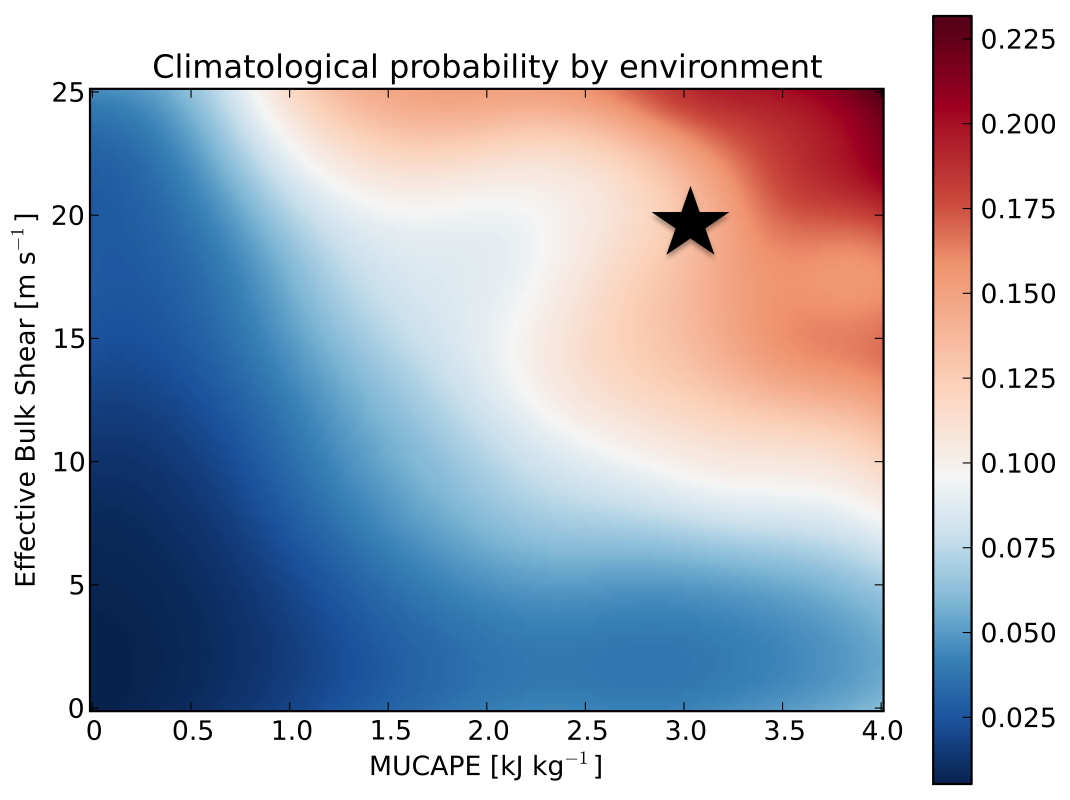
Hypothetical severe thunderstorm with 3,000 J/kg of MUCAPE and 20 m/s EBS from the RAP compsite.
Yes-class prior probability = 0.17. (No-class prior probability = 1 - 0.17 = 0.83)
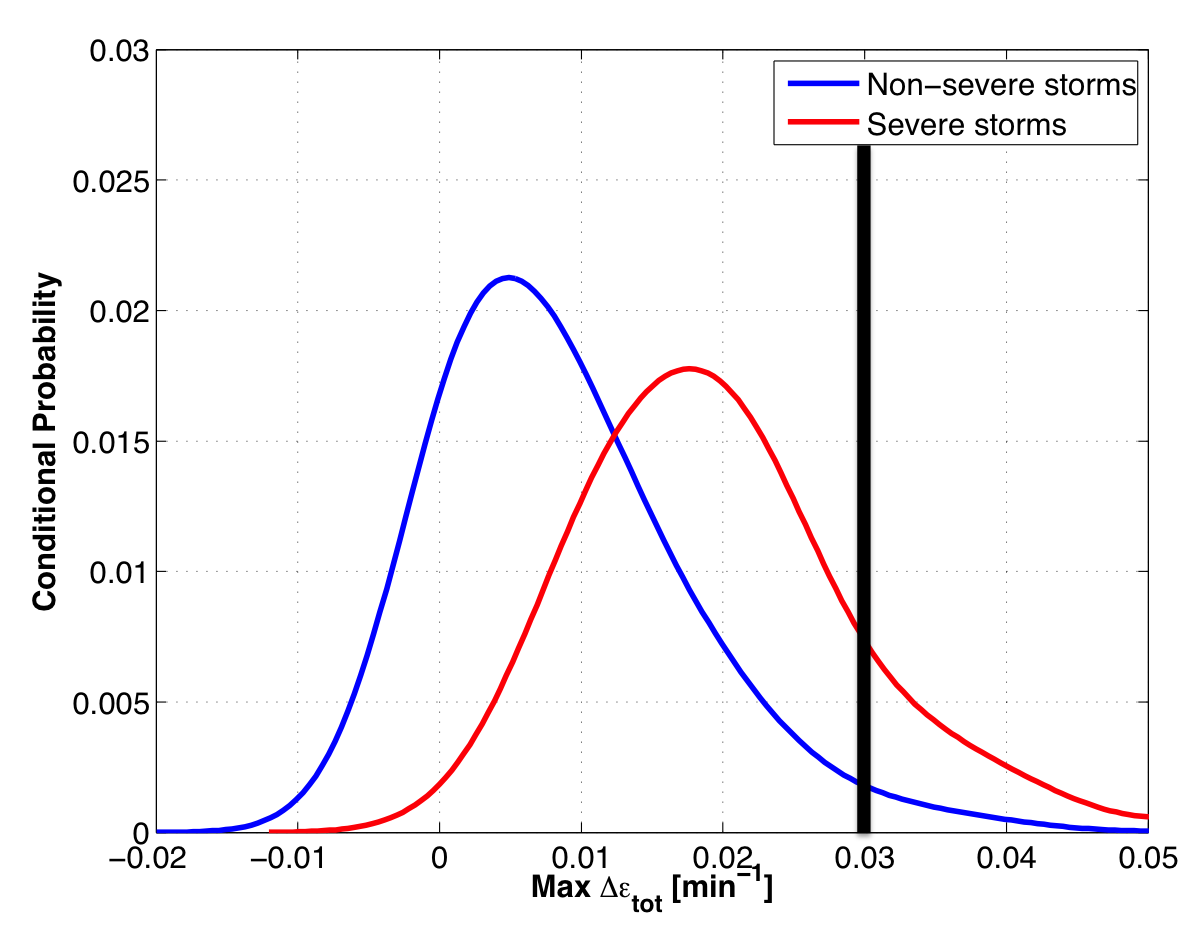
Hypothetical severe thunderstorm normalized vertical growth rate of 3.0%/min.
Yes-class conditional prob = 0.008
No-class conditional prob = 0.0015
|
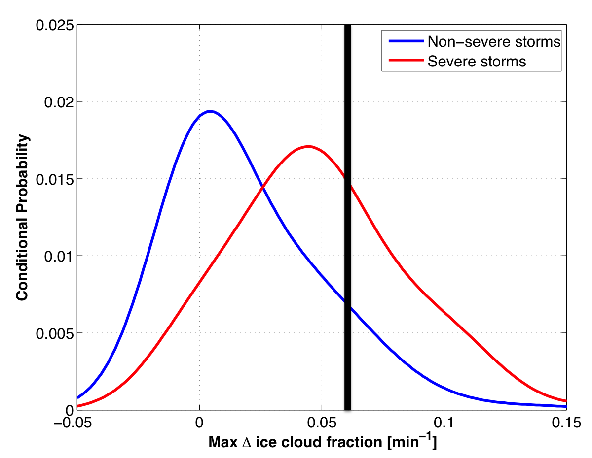
Hypothetical severe thunderstorm glaciation rate of 0.06/min.
Yes-class conditional prob = 0.015
No-class conditional prob = 0.007
|
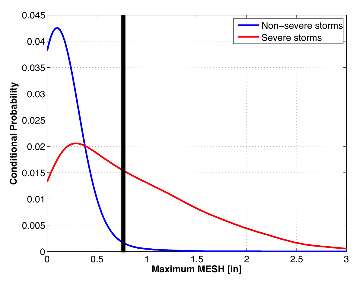
Hypothetical severe thunderstorm MRMS MESH of 0.75".
Yes-class conditional prob = 0.016
No-class conditional prob = 0.001
|
Combining all the class-conditional probabilities and prior probabilities yields an end probability of 97%. Or this hypothetical severe thunderstorm has a
97% chance of first producing severe weather in the next 60 minutes. The very high probability is attributed to a favorable environment, strong satellite growth rates,
and a large, yet still sub-severe MRMS MESH value.
