Earth image  HomeAbout the CourseModulesGlossaryReal-time DataGallery
Monitoring the Global Environment

Monitoring the Global Environment

Beginning of Module


Created by UW-Madison, 2002
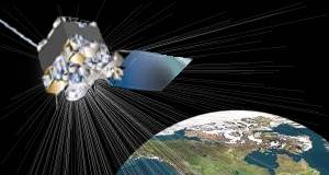
Technological breakthroughs in the 1990's paved the way for incredible remote sensing capabilities for the 21st century.

These enhanced capabilities are utilized by dozens of satellites continuously collecting data from multiple vantage points, allowing scientists from different countries to transcend political and geographical boundaries by sharing data and ideas towards the common mission of caring for planet Earth.

In this module, you will learn:

  • How geostationary satellites are used to detect forest fires & monitor biomass burning
  • The connection between biomass burning and global warming
  • NASA's research satellite program designed to monitor "the pulse of the planet"
  • Using satellite images to identify Urban Heat Islands, and
  • The next polar orbiting satellite program - (NPOESS)