
|
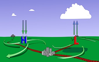
Air is lifted in and around areas of low pressure. Remember, air pressure is the weight of the atmosphere above you. When there is a large area of low pressure, there is less air above so the air at the surface tends to rise. Alternatively, an area of high pressure is like a hill of air in the atmosphere. The air in and around high pressure sinks and spreads outward at the surface. Another way to think about low and high pressure is to consider how and why the wind blows. Wind is air in motion. The wind blows from areas of high pressure to areas of low pressure. Some of this is rising and sinking air (vertical motion) but most of the time when we talk about winds we are talking about horizontal motion along the surface. A forecast of south winds of 12 to 20 mph means the surface winds will be 12 to 20 miles per hour FROM the south.
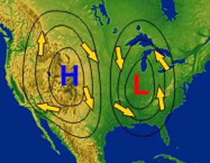
This image shows the general pattern of air flow around low and high pressure. Air is feeding into the center of a low at the surface in a counter-clockwise direction. When the air meets in the middle of a low, it has to rise (it can't dive down into the Earth) and as it cools clouds are formed. The opposite circulation occurs around highs with sinking air spreading out in a clockwise direction. An L on a weather map shows where the weather action is. Low pressure regions always create clouds and usually precipitation because the rising air cools and the water vapor condenses. High pressure regions are usually associated with dry weather because as the air sinks it gradually warms up and the moisture evaporates. Continue with the module |